
Usòrò:African continent-en.svg

Size of this PNG preview of this SVG file: 635 × 600 piksels. Ndị ọzọ mkpebi:254 × 240 piksels | 508 × 480 piksels | 813 × 768 piksels | 1,084 × 1,024 piksels | 2,169 × 2,048 piksels | 1,525 × 1,440 piksels.
Failụ si na nke mbu (usòrò SVG, nà áhà pixel 1,525 × 1,440, ívụ usòrò: 752 KB)
| Nkówá |
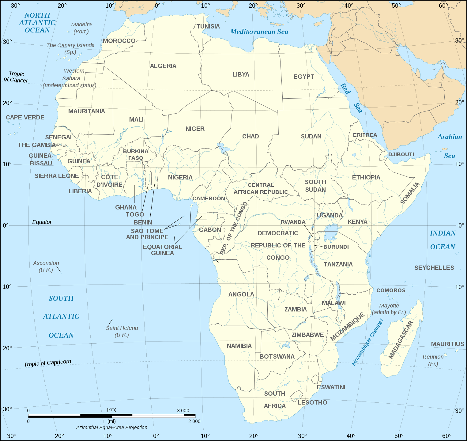
English: Map of the African continent as in 2011-07.
Français : Carte en anglais du continent africain tel qu'en 07/2011.
Lambert azimutal equal-area projection, WGS84 datum, standard meridian: 15°E, standard parallel: 0°Scale: 1:15,000,000 (accuracy: 3,75 km) |
||
| Ǹgụ́ụ̀bọ̀chị̀ | (UTC), updated 2011-07 | ||
| Mkpọlọ́gwụ̀ | |||
| Odé ákwụ́kwọ́ |
|
||
| Nke ya ozor |
Derivative works of this file:
[]
Map close to Africa map political-fr.svg, but with some changes on the islands administrated by European countries and the Sinai peninsula |
||
| SVG genesis |
|


I, the copyright holder of this work, hereby publish it under the following license:
This file is licensed under the Creative Commons Attribution-Share Alike 2.5 Generic, 2.0 Generic and 1.0 Generic license.
- I wepulara nóru:
- i nye – ikọpị,ikekasi na izịpụ ọru a
- i dowaria – igbanwee ọrụ a
- Ọ ga bụ na ọnọdụ ndi a:
- í-kpó-áhà – Ị ga-enyerịrị ugo kwesịrị ekwesị, nye njikọ na ikikere ahụ, ma gosikwa ma emere mgbanwe. Ị nwere ike ime ya n'ụzọ ezi uche ọ bụla, mana ọ bụghị n'ụzọ ọ bụla na-egosi na onye nyere ikikere kwadoro gị maọbụ ojiji gị.
- gbásàa kà – Ọ bụrụ na ị tụgharịgharịa, gbanwee, ma ọ bụ wulite n'elu ihe ahụ, ị ga-ekesa ndenye gị n'okpuru otu ma ọ bụ ikike dakọtara dị ka nke mbụ.
Original upload log
This image is a derivative work of the following images:
- Image:Africa_map_blank.svg licensed with Cc-by-sa-2.5,2.0,1.0, Cc-by-sa-2.5,2.0,1.0/en
- 2008-06-27T03:34:58Z Sting 1525x1440 (711453 Bytes) Completely new drawing with known projection
- 2006-05-31T15:28:42Z Sting 1390x1295 (571519 Bytes) Enhanced version : African and Asian continents separated
- 2006-05-31T03:53:32Z Sting 1390x1295 (566642 Bytes) {{Information |Description=Blank vector graphic map of [[:Category:Maps of Africa|Africa]] |Source=Several bitmap-type maps |Date= May 2006 |Author= Eric Gaba ({{U|Sting}}) |Permission=GFDL or CC-BY-SA |other_version
Uploaded with derivativeFX
Ịta nke usòrò
Bìri èhì/ogè k'ị hụ òtù ụ̀fa dị̀ m̀gbè ahụ̀.
| Èhì/Ogè | Mbọ-aka | Ógólógó na asaá | Òjìème | Nkwute | |
|---|---|---|---|---|---|
| dị ùgbu â | 18:21, 6 Disemba 2020 | | 1,525 × 1,440 (752 KB) | Sting | Swatziland => eSwatini |
| 19:59, 14 Julaị 2011 |  | 1,525 × 1,440 (752 KB) | Sting | Sudan/South Sudan 2011-07 border update | |
| 16:42, 16 Disemba 2010 |  | 1,525 × 1,440 (747 KB) | Sting | Spelling correction: Madeira | |
| 20:16, 10 Jenụwarị 2009 |  | 1,525 × 1,440 (747 KB) | Sting | Correction Sao Tome | |
| 08:37, 6 Disemba 2008 |  | 1,525 × 1,440 (750 KB) | Bobarino | {{Information |Description={{en|Map of the African continent.}} {{fr|Carte vierge du continent africain.}} Lambert azimutal equal-area projection, WGS84 datum, standard meridian: 15°E, standard pa |
Ojiji faịlụ
Ihe ndị na-eso ihe eji Ihu akwụkwọ eme na faịlụ a:
Ejiji failụ zụrụ ọha
Wikis ndi a edeputara na eji kwa failụ a:
- Ihe eji na af.wikipedia.org
- Ihe eji na ar.wikipedia.org
- Ihe eji na azb.wikipedia.org
- Ihe eji na az.wiktionary.org
- Ihe eji na de.wikipedia.org
- Ihe eji na en.wikipedia.org
- Ihe eji na fa.wikipedia.org
- Ihe eji na hi.wikipedia.org
- Ihe eji na hu.wikibooks.org
- Ihe eji na id.wikipedia.org
- Ihe eji na ilo.wikipedia.org
- Ihe eji na ja.wikipedia.org
- Ihe eji na ko.wikipedia.org
- Ihe eji na www.mediawiki.org
- Ihe eji na ml.wikipedia.org
- Ihe eji na mn.wikipedia.org
- Ihe eji na nl.wikipedia.org
- Ihe eji na sd.wikipedia.org
- Ihe eji na simple.wikipedia.org
- Ihe eji na sw.wikipedia.org
- Ihe eji na te.wikipedia.org
- Ihe eji na th.wikipedia.org
- Ihe eji na tr.wikipedia.org
- Ihe eji na uz.wikipedia.org
- Ihe eji na yo.wikipedia.org