
Usòrò:EU-Hungary.svg

Size of this PNG preview of this SVG file: 713 × 600 piksels. Ndị ọzọ mkpebi:285 × 240 piksels | 571 × 480 piksels | 913 × 768 piksels | 1,218 × 1,024 piksels | 2,435 × 2,048 piksels | 2,045 × 1,720 piksels.
Failụ si na nke mbu (usòrò SVG, nà áhà pixel 2,045 × 1,720, ívụ usòrò: 7.33 MB)
Mmẹkụwátá
| Nkówá |
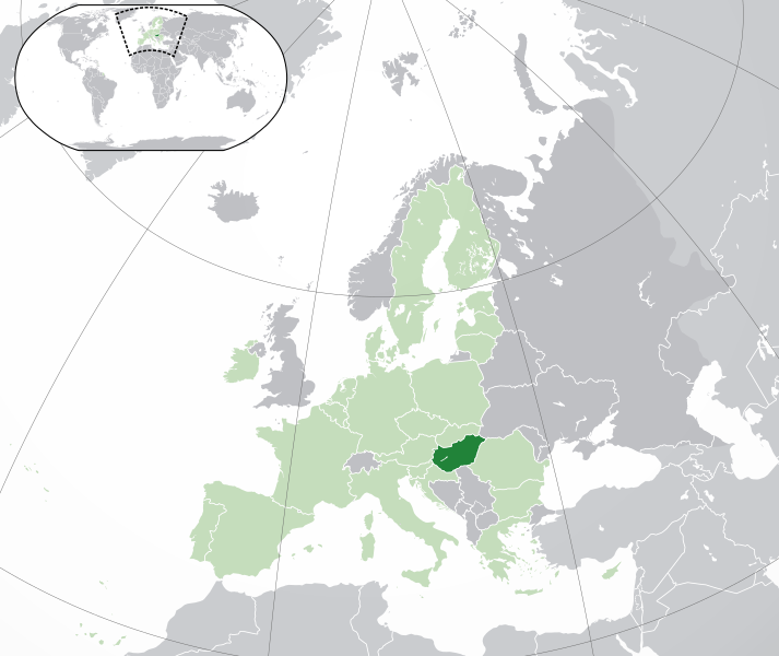
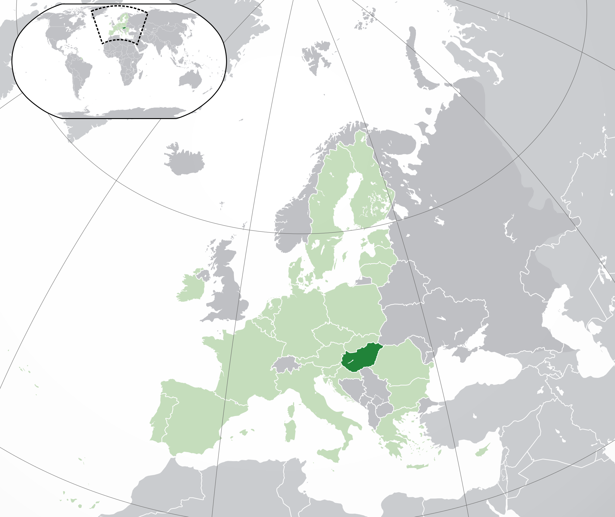
English: (Dark-Green) Hungary. (Light-Green) The rest of the European Union (EU). (Dark-gray) The rest of Europe. (Light-gray) The surrounding region.
See also: |
| SVG genesis | |
| Ǹgụ́ụ̀bọ̀chị̀ | |
| Mkpọlọ́gwụ̀ | |
| Odé ákwụ́kwọ́ | NuclearVacuum |
| Nke ya ozor |
|


Nkwényé
I, the copyright holder of this work, hereby publish it under the following licenses:
Edebere faịlụ a n'okpuru ikikeree Creative Commons Attribution-Share Alike 3.0 Unported license.
- I wepulara nóru:
- i nye – ikọpị,ikekasi na izịpụ ọru a
- i dowaria – igbanwee ọrụ a
- Ọ ga bụ na ọnọdụ ndi a:
- í-kpó-áhà – Ị ga-enyerịrị ugo kwesịrị ekwesị, nye njikọ na ikikere ahụ, ma gosikwa ma emere mgbanwe. Ị nwere ike ime ya n'ụzọ ezi uche ọ bụla, mana ọ bụghị n'ụzọ ọ bụla na-egosi na onye nyere ikikere kwadoro gị maọbụ ojiji gị.
- gbásàa kà – Ọ bụrụ na ị tụgharịgharịa, gbanwee, ma ọ bụ wulite n'elu ihe ahụ, ị ga-ekesa ndenye gị n'okpuru otu ma ọ bụ ikike dakọtara dị ka nke mbụ.

|
Í nwèrèíkí jé, gbạsáa na/ma í mezí akwukwo nka na okpúrù íwú GNU Ákwúkwó Íwú nke Owéré, Nké 1.2 ma nke íchè ndi Free Software Foundation; wéfùtàrà; na adighi nkejị di íchẹ, adighi édé nke Ihú-Ihü Ákwúkwó, na adighi Ázú-Ihü Ákwúkwó. Ákwúkwó iwu hé jéré jé di na nkeji kpóró GNU Ákwúkwó Íwú nke Owéré". |
Ị nwere ike họrọ ikikere nke masịrị gị.
Ịta nke usòrò
Bìri èhì/ogè k'ị hụ òtù ụ̀fa dị̀ m̀gbè ahụ̀.
| Èhì/Ogè | Mbọ-aka | Ógólógó na asaá | Òjìème | Nkwute | |
|---|---|---|---|---|---|
| dị ùgbu â | 05:02, 1 Febụwarị 2020 | | 2,045 × 1,720 (7.33 MB) | Rob984 | UK and Gibraltar have left the EU. New base which includes all of Portugal's islands within frame, as well as Arctic Russian islands part of Europe. Also fixed Flevoland in the Netherlands. |
| 20:29, 25 Ọktoba 2016 |  | 2,045 × 1,720 (7.32 MB) | Giorgi Balakhadze | + some lakes | |
| 11:55, 4 Febụwarị 2015 |  | 2,045 × 1,720 (2.62 MB) | BRUTE | Reverted to version as of 16:33, 16 November 2014 Please respect COM:OVERWRITE | |
| 19:39, 16 Novemba 2014 |  | 2,045 × 1,720 (7.38 MB) | Leftcry | Reverted to version as of 23:04, 18 October 2014 Please go to your talk page | |
| 16:33, 16 Novemba 2014 |  | 2,045 × 1,720 (2.62 MB) | A2D2 | The map must show the original de-jure status with no breakaway regions, as it was originally created. An alternative map showing the de-facto status with breakaway regions needs to be created instead. | |
| 23:04, 18 Ọktoba 2014 |  | 2,045 × 1,720 (7.38 MB) | Leftcry | Improved version | |
| 09:04, 1 Julaị 2013 |  | 2,045 × 1,720 (2.62 MB) | U5K0 | croatia | |
| 12:36, 10 Julaị 2012 |  | 2,045 × 1,720 (2.62 MB) | Domaina | minor | |
| 00:46, 23 Ọktoba 2009 |  | 2,045 × 1,720 (2.61 MB) | NuclearVacuum | consensus version | |
| 18:13, 18 Ọktoba 2009 |  | 2,045 × 1,720 (2.62 MB) | NuclearVacuum | final version |
Ojiji faịlụ
Ihe ndị na-eso ihe eji Ihu akwụkwọ eme na faịlụ a:
Ejiji failụ zụrụ ọha
Wikis ndi a edeputara na eji kwa failụ a:
- Ihe eji na ady.wikipedia.org
- Ihe eji na af.wikipedia.org
- Ihe eji na als.wikipedia.org
- Ihe eji na ami.wikipedia.org
- Ihe eji na ang.wikipedia.org
- Ihe eji na arc.wikipedia.org
- Ihe eji na ar.wikipedia.org
- المجر
- مستخدم:ElWaliElAlaoui/ملعب 8
- معاملة المثليين في المجر
- مستخدم:جار الله/قائمة صور مقالات العلاقات الثنائية
- العلاقات المجرية الأمريكية
- العلاقات الأنغولية المجرية
- العلاقات المجرية الكورية الجنوبية
- العلاقات المجرية الإريترية
- العلاقات المجرية السويسرية
- العلاقات الألمانية المجرية
- العلاقات المجرية الليختنشتانية
- العلاقات المجرية البوليفية
- العلاقات المجرية الموزمبيقية
- العلاقات الألبانية المجرية
- العلاقات المجرية البلجيكية
- العلاقات المجرية الإثيوبية
- العلاقات المجرية البيلاروسية
- العلاقات المجرية الطاجيكستانية
- العلاقات المجرية الرومانية
- العلاقات الأرجنتينية المجرية
- العلاقات المجرية الغامبية
- العلاقات المجرية القبرصية
- العلاقات المجرية السيراليونية
- العلاقات المجرية النيبالية
- العلاقات المجرية الليبيرية
- العلاقات التشيكية المجرية
- العلاقات المجرية الميانمارية
- العلاقات المجرية الكندية
- العلاقات السعودية المجرية
- العلاقات المجرية الزيمبابوية
- العلاقات المجرية الإسرائيلية
- العلاقات المجرية البالاوية
- العلاقات المجرية المالية
- العلاقات المجرية النيجيرية
- العلاقات المجرية اليمنية
- العلاقات المجرية الفانواتية
- العلاقات الغابونية المجرية
- العلاقات المجرية البنمية
- العلاقات المجرية الكوبية
- العلاقات المجرية الجورجية
- العلاقات المجرية التونسية
- العلاقات المجرية الكورية الشمالية
- العلاقات المجرية الهندية
Lee more global usage of this file.