
Usòrò:Benuerivermap.png
Otu nyochaa a ha:600 × 600 piksels Ndị ọzọ mkpebi:240 × 240 piksels | 480 × 480 piksels | 1,000 × 1,000 piksels.
Failụ si na nke mbu (1,000 × 1,000 pixel, ívù akwukwo orunótu: 1.51 MB, MIME nke: image/png)
Mmẹkụwátá
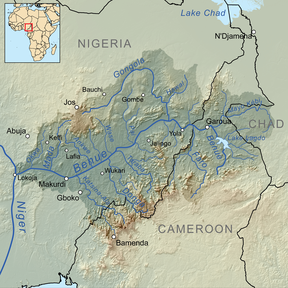
| Nkówá | Map showing the Benue River drainage basin. |
| Ǹgụ́ụ̀bọ̀chị̀ | |
| Mkpọlọ́gwụ̀ | Orü ọnwé, Elevation data from SRTM, drainage basin from GTOPO [1], all other features from Vector Map. |
| Odé ákwụ́kwọ́ | Kmusser |
Nkwényé
I, the copyright holder of this work, hereby publish it under the following license:
Edebere faịlụ a n'okpuru ikikeree Creative Commons Attribution-Share Alike 3.0 Unported license.
- I wepulara nóru:
- i nye – ikọpị,ikekasi na izịpụ ọru a
- i dowaria – igbanwee ọrụ a
- Ọ ga bụ na ọnọdụ ndi a:
- í-kpó-áhà – Ị ga-enyerịrị ugo kwesịrị ekwesị, nye njikọ na ikikere ahụ, ma gosikwa ma emere mgbanwe. Ị nwere ike ime ya n'ụzọ ezi uche ọ bụla, mana ọ bụghị n'ụzọ ọ bụla na-egosi na onye nyere ikikere kwadoro gị maọbụ ojiji gị.
- gbásàa kà – Ọ bụrụ na ị tụgharịgharịa, gbanwee, ma ọ bụ wulite n'elu ihe ahụ, ị ga-ekesa ndenye gị n'okpuru otu ma ọ bụ ikike dakọtara dị ka nke mbụ.
Ịta nke usòrò
Bìri èhì/ogè k'ị hụ òtù ụ̀fa dị̀ m̀gbè ahụ̀.
| Èhì/Ogè | Mbọ-aka | Ógólógó na asaá | Òjìème | Nkwute | |
|---|---|---|---|---|---|
| dị ùgbu â | 16:00, 8 Ọktoba 2010 | | 1,000 × 1,000 (1.51 MB) | Kmusser | +Wukari |
| 16:06, 7 Eprel 2010 |  | 1,000 × 1,000 (1.63 MB) | Kmusser | +N'Djamena | |
| 16:02, 7 Eprel 2010 |  | 1,000 × 1,000 (1.63 MB) | Kmusser | Flip basin highlighting | |
| 15:35, 1 Eprel 2010 |  | 1,000 × 1,000 (1.51 MB) | Kmusser | == Summary == {{Information |Description=Map showing the Benue River drainage basin. |Source={{own}}, Elevation data from SRTM, drainage basin from GTOPO [http://eros.usgs.gov/#/Find_Data/Products |
Ojiji faịlụ
Ihe ndị na-eso ihe eji Ihu akwụkwọ eme na faịlụ a:
Ejiji failụ zụrụ ọha
Wikis ndi a edeputara na eji kwa failụ a:
- Ihe eji na af.wikipedia.org
- Ihe eji na ar.wikipedia.org
- Ihe eji na arz.wikipedia.org
- Ihe eji na ast.wikipedia.org
- Ihe eji na ba.wikipedia.org
- Ihe eji na be.wikipedia.org
- Ihe eji na bg.wikipedia.org
- Ihe eji na bs.wikipedia.org
- Ihe eji na ca.wikipedia.org
- Ihe eji na cs.wikipedia.org
- Ihe eji na da.wikipedia.org
- Ihe eji na de.wikipedia.org
- Ihe eji na el.wikipedia.org
- Ihe eji na en.wikipedia.org
- Ihe eji na eo.wikipedia.org
- Ihe eji na es.wikipedia.org
- Ihe eji na eu.wikipedia.org
- Ihe eji na fi.wikipedia.org
- Ihe eji na fr.wikipedia.org
- Ihe eji na fy.wikipedia.org
- Ihe eji na gl.wikipedia.org
- Ihe eji na ha.wikipedia.org
Lee more global usage of this file.