
Usòrò:Embalse Guri.JPG

Otu nyochaa a ha:600 × 600 piksels Ndị ọzọ mkpebi:240 × 240 piksels | 480 × 480 piksels | 640 × 640 piksels.
Failụ si na nke mbu (640 × 640 pixel, ívù akwukwo orunótu: 158 KB, MIME nke: image/jpeg)
Mmẹkụwátá
| Nkówá |
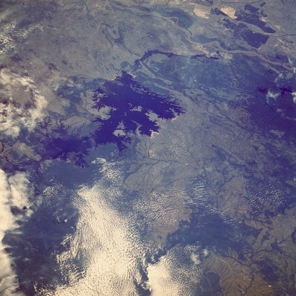
English: The Caroní River and the Guri Reservoir (Venezuela).
Français : La rivière Caroní et le lac de barrage de Guri, au Venezuela. |
| Ǹgụ́ụ̀bọ̀chị̀ | |
| Mkpọlọ́gwụ̀ |
Image Science and Analysis Laboratory, NASA-Johnson Space Center. |
| Odé ákwụ́kwọ́ | NASA, Mission: STS61A |
Location of the Guri Dam (Central Hidroeléctrica Simón Bolívar), on the Caroní River
| Object location | | View this and other nearby images on: OpenStreetMap |
|---|
Nkwényé
| This file is in the public domain in the United States because it was solely created by NASA. NASA copyright policy states that "NASA material is not protected by copyright unless noted". (See Template:PD-USGov, NASA copyright policy page or JPL Image Use Policy.) | ||
 |
Warnings:
|
| Annotations | This image is annotated: View the annotations at Commons |

|
This image has been assessed under the valued image criteria and is considered the most valued image on Commons within the scope: Caroní River. You can see its nomination here. |
Ịta nke usòrò
Bìri èhì/ogè k'ị hụ òtù ụ̀fa dị̀ m̀gbè ahụ̀.
| Èhì/Ogè | Mbọ-aka | Ógólógó na asaá | Òjìème | Nkwute | |
|---|---|---|---|---|---|
| dị ùgbu â | 13:06, 17 Ọktoba 2005 | | 640 × 640 (158 KB) | Venex | Imagen del Embalse de Guri en Venezuela desde el espacio. |
Ojiji faịlụ
Ihe ndị na-eso ihe eji Ihu akwụkwọ eme na faịlụ a:
Ejiji failụ zụrụ ọha
Wikis ndi a edeputara na eji kwa failụ a:
- Ihe eji na be.wikipedia.org
- Ihe eji na ca.wikipedia.org
- Ihe eji na de.wikipedia.org
- Ihe eji na en.wikipedia.org
- Ihe eji na es.wikipedia.org
- Ihe eji na eu.wikipedia.org
- Ihe eji na fr.wikipedia.org
- Ihe eji na hr.wikipedia.org
- Ihe eji na lt.wikipedia.org
- Ihe eji na nl.wikipedia.org
- Ihe eji na pt.wikipedia.org
- Ihe eji na qu.wikipedia.org
- Ihe eji na ru.wikipedia.org
- Ihe eji na sh.wikipedia.org
- Ihe eji na sl.wikipedia.org
- Ihe eji na uk.wikipedia.org
- Ihe eji na vi.wikipedia.org
- Ihe eji na www.wikidata.org
- Ihe eji na zh.wikipedia.org