
Usòrò:Lake Chad’s shrinking waters ESA418540.gif
Failụ si na nke mbu (2,802 × 2,802 pixel, ívù akwukwo orunótu: 11.7 MB, MIME nke: image/gif, etemte, 2 frames, 6.0 s)
Mmẹkụwátá
| Nkówá |
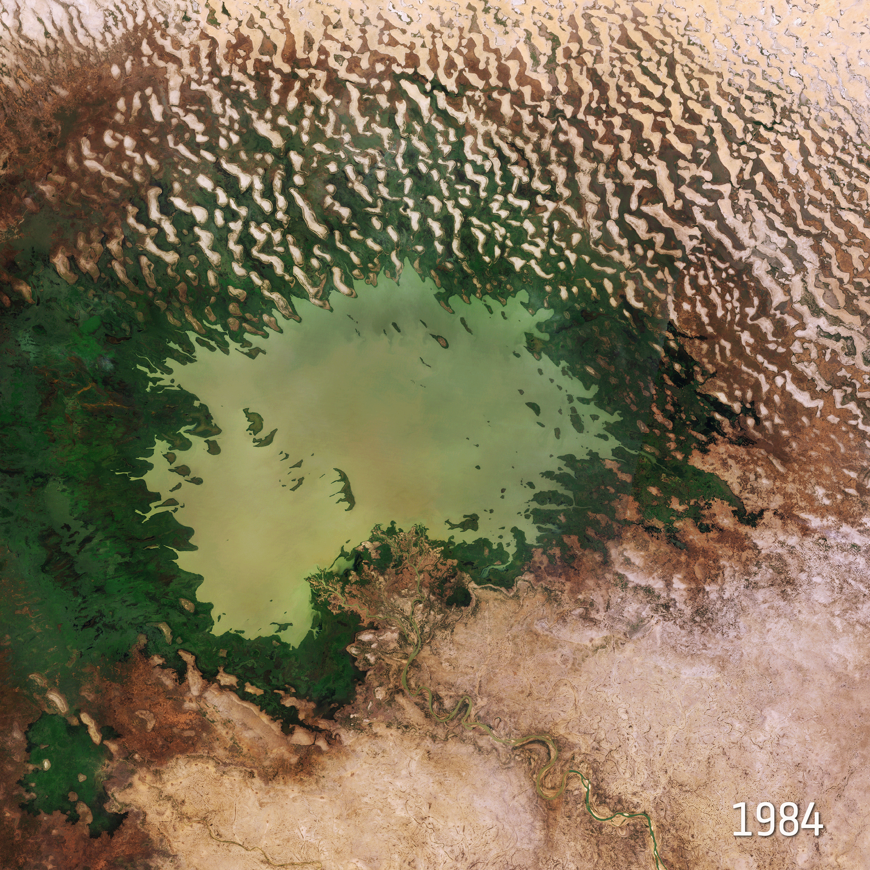
English: The 22 March isWorld Water Day, which focuses on the importance of freshwater. The Sustainable Development Goals of the United Nations aim to achieve a better and more sustainable future. Goal number 6 focuses on ensuring the availability and sustainable management of water for all by 2030. This image takes us over Lake Chad at the southern edge of the Sahara, where water supplies are dwindling.
This comparison shows Lake Chad imaged on 6 November 1984 by the US Landsat 5 satellite and on 31 October 2018 by the Copernicus Sentinel-2A satellite. The rapid decline of the lake’s waters in just 34 years is clear to see. Once one of Africa’s largest lakes, Lake Chad has shrunk by around 90% since the 1960s. This receding water is down to a reduction of precipitation, induced by climate change, as well as development of modern irrigation systems for agriculture and the increasing human demand for freshwater. Straddling the border of Chad, Niger, Cameroon and Nigeria, the lake is a major source of freshwater for millions of people in the area. It is also a source for irrigation, fishing and it was once rich in biodiversity. As the lake continues to dry up, many farmers and herders move towards greener areas or move to larger cities to seek alternative work. Several attempts have been made to replenish these shrinking waters, however little progress has been achieved. The borders of the lake’s body are only partly visible in the most-recent image – as the majority of the shoreline is swamp and marsh. The Chari River, visible snaking its way towards Lake Chad at the bottom of the image, provides over 90% of the lake’s waters. It flows from the Central African Republic following the Cameroon border from N'Djamena, where it joins with its main tributary the Logone River. The demand for water is growing inexorably. Access to water is vital – not only for drinking, but also for agriculture, energy and sanitation. By providing measurements of water quality and detecting changes, the Copernicus Sentinel-2 mission can support the sustainable management of water resources. These images are also featured on theEarth from Space video programme. UN Sustainable Goal 6 is crystal clear: Water for all by 2030. SDG6 includes a target to ensure availability and sustainable management of water for all by 2030. For World Water Day we take a look at ways that space can help this global challenge. While Earth-observing satellites monitor our precious water resources, technologies developed for human space missions also serve global needs in harsh environments here on Earth. |
| Ǹgụ́ụ̀bọ̀chị̀ | |
| Mkpọlọ́gwụ̀ | http://www.esa.int/spaceinimages/Images/2019/03/Lake_Chad_s_shrinking_waters |
| Odé ákwụ́kwọ́ | European Space Agency |
| Ọdà (Í jí kwá usòrò nke) |
contains modified Copernicus Sentinel data (2018), processed by ESA (For Landsat image: USGS/ESA),CC BY-SA 3.0 IGO |
| Title | Lake Chad’s shrinking waters |
| System | Landsat-5 |
| Set | Earth observation image of the week |
| Mission | Sentinel-2 |
| Activity | Observing the Earth |
Nkwényé
- I wepulara nóru:
- i nye – ikọpị,ikekasi na izịpụ ọru a
- i dowaria – igbanwee ọrụ a
- Ọ ga bụ na ọnọdụ ndi a:
- í-kpó-áhà – Ị ga-enyerịrị ugo kwesịrị ekwesị, nye njikọ na ikikere ahụ, ma gosikwa ma emere mgbanwe. Ị nwere ike ime ya n'ụzọ ezi uche ọ bụla, mana ọ bụghị n'ụzọ ọ bụla na-egosi na onye nyere ikikere kwadoro gị maọbụ ojiji gị.
- gbásàa kà – Ọ bụrụ na ị tụgharịgharịa, gbanwee, ma ọ bụ wulite n'elu ihe ahụ, ị ga-ekesa ndenye gị n'okpuru otu ma ọ bụ ikike dakọtara dị ka nke mbụ.

|
This image contains data from a satellite in the Copernicus Programme, such as Sentinel-1, Sentinel-2 or Sentinel-3. Attribution is required when using this image.
Í-kpó-áhà: Contains modified Copernicus Sentinel data {{{year}}}
The use of Copernicus Sentinel Data is regulated under EU law (Commission Delegated Regulation (EU) No 1159/2013 and Regulation (EU) No 377/2014). Relevant excerpts:
Free access shall be given to GMES dedicated data [...] made available through GMES dissemination platforms [...].
Access to GMES dedicated data [...] shall be given for the purpose of the following use in so far as it is lawful:
GMES dedicated data [...] may be used worldwide without limitations in time.
GMES dedicated data and GMES service information are provided to users without any express or implied warranty, including as regards quality and suitability for any purpose. |
Ịta nke usòrò
Bìri èhì/ogè k'ị hụ òtù ụ̀fa dị̀ m̀gbè ahụ̀.
| Èhì/Ogè | Mbọ-aka | Ógólógó na asaá | Òjìème | Nkwute | |
|---|---|---|---|---|---|
| dị ùgbu â | 12:24, 3 Eprel 2019 | | 2,802 × 2,802 (11.7 MB) | Fæ | European Space Agency, Id 418540, http://www.esa.int/spaceinimages/Images/2019/03/Lake_Chad_s_shrinking_waters, User:Fæ/Project_list/ESA |
Ojiji faịlụ
Ihe ndị na-eso ihe eji Ihu akwụkwọ eme na faịlụ a:
Ejiji failụ zụrụ ọha
Wikis ndi a edeputara na eji kwa failụ a:
- Ihe eji na af.wikipedia.org
- Ihe eji na en.wikipedia.org
- Ihe eji na hy.wikipedia.org
- Ihe eji na zh.wikipedia.org