
Usòrò:ROC Administrative and Claims.svg

Size of this PNG preview of this SVG file: 754 × 600 piksels. Ndị ọzọ mkpebi:302 × 240 piksels | 603 × 480 piksels | 965 × 768 piksels | 1,280 × 1,019 piksels | 2,560 × 2,037 piksels.
Failụ si na nke mbu (usòrò SVG, nà áhà pixel 754 × 600, ívụ usòrò: 676 KB)
Mmẹkụwátá
| Nkówá |
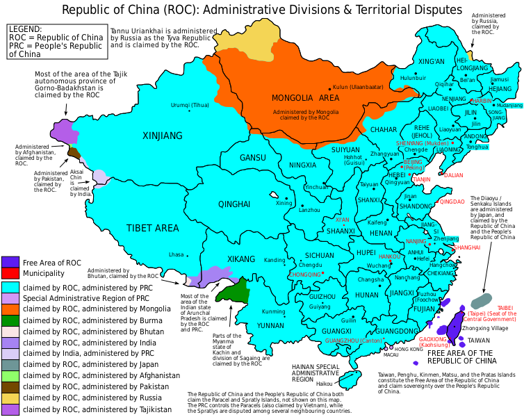
English: Map of the Republic of China (1953-2005), showing administrative divisions and territorial disputes. |
| Ǹgụ́ụ̀bọ̀chị̀ | (UTC) |
| Mkpọlọ́gwụ̀ | I (ZanderSchubert (talk)) created this work entirely by myself. |
| Odé ákwụ́kwọ́ | User:ZanderSchubert |
| Nke ya ozor |
Based on a previous version of File:ROC_Administrative_and_Claims.jpg See also the other versions of this file:
Derivative works of this file: |


|
This SVG file contains embedded text that can be translated into your language, using any capable SVG editor, text editor or the SVG Translate tool. For more information see: About translating SVG files. |
Nkwényé
I, the copyright holder of this work, hereby publish it under the following licenses:

|
Í nwèrèíkí jé, gbạsáa na/ma í mezí akwukwo nka na okpúrù íwú GNU Ákwúkwó Íwú nke Owéré, Nké 1.2 ma nke íchè ndi Free Software Foundation; wéfùtàrà; na adighi nkejị di íchẹ, adighi édé nke Ihú-Ihü Ákwúkwó, na adighi Ázú-Ihü Ákwúkwó. Ákwúkwó iwu hé jéré jé di na nkeji kpóró GNU Ákwúkwó Íwú nke Owéré". |
This file is licensed under the Creative Commons Attribution-Share Alike 4.0 International, 3.0 Unported, 2.5 Generic, 2.0 Generic and 1.0 Generic license.
- I wepulara nóru:
- i nye – ikọpị,ikekasi na izịpụ ọru a
- i dowaria – igbanwee ọrụ a
- Ọ ga bụ na ọnọdụ ndi a:
- í-kpó-áhà – Ị ga-enyerịrị ugo kwesịrị ekwesị, nye njikọ na ikikere ahụ, ma gosikwa ma emere mgbanwe. Ị nwere ike ime ya n'ụzọ ezi uche ọ bụla, mana ọ bụghị n'ụzọ ọ bụla na-egosi na onye nyere ikikere kwadoro gị maọbụ ojiji gị.
- gbásàa kà – Ọ bụrụ na ị tụgharịgharịa, gbanwee, ma ọ bụ wulite n'elu ihe ahụ, ị ga-ekesa ndenye gị n'okpuru otu ma ọ bụ ikike dakọtara dị ka nke mbụ.
Ị nwere ike họrọ ikikere nke masịrị gị.
Ịta nke usòrò
Bìri èhì/ogè k'ị hụ òtù ụ̀fa dị̀ m̀gbè ahụ̀.
| Èhì/Ogè | Mbọ-aka | Ógólógó na asaá | Òjìème | Nkwute | |
|---|---|---|---|---|---|
| dị ùgbu â | 10:38, 4 Jụn 2015 | | 754 × 600 (676 KB) | Storkk | fix typo ("Most if ... Arunchal Pradesh" -> "Most of ...") |
| 20:09, 25 Disemba 2014 |  | 754 × 600 (658 KB) | Koavf | Burma | |
| 13:24, 4 Mee 2012 |  | 754 × 600 (677 KB) | Michaeldsuarez | Removing typo: "[…] claimed by the Republic of China an the People's Republic of China" to "[…] claimed by the Republic of China and the People's Republic of China." | |
| 08:02, 5 Ọgọọst 2011 |  | 754 × 600 (677 KB) | ZanderSchubert | Changing place names to Pinyin and correcting some previous errors. | |
| 01:00, 5 Mee 2011 |  | 754 × 600 (675 KB) | ZanderSchubert | Changing "Republic of Mongolia" to "Mongolia" | |
| 04:22, 12 Febụwarị 2011 |  | 754 × 600 (675 KB) | ZanderSchubert | {{Information |Description ={{en|1=Map of the Republic of China, showing administrative divisions and territorial disputes.}} |Source =I (ZanderSchubert (talk)) created this work entirely by |
Ojiji faịlụ
Ihe ndị na-eso ihe eji Ihu akwụkwọ eme na faịlụ a:
Ejiji failụ zụrụ ọha
Wikis ndi a edeputara na eji kwa failụ a:
- Ihe eji na af.wikipedia.org
- Ihe eji na ar.wikipedia.org
- Ihe eji na ast.wikipedia.org
- Ihe eji na azb.wikipedia.org
- Ihe eji na ban.wikipedia.org
- Ihe eji na be-tarask.wikipedia.org
- Ihe eji na be.wikipedia.org
- Ihe eji na bn.wikipedia.org
- Ihe eji na ca.wikipedia.org
- Ihe eji na cs.wikipedia.org
- Ihe eji na de.wikipedia.org
- Ihe eji na el.wikipedia.org
- Ihe eji na en.wikipedia.org
- Taiwan
- User:Jaques O. Carvalho
- Exclusive mandate
- User:Andyso/Userboxes
- User:Andyso/template:userboxes
- Template:User ROC Support
- Talk:2011 Cricket World Cup/Archive 2
- Talk:List of sovereign states/Archive 10
- Talk:Chinese civilization/Archive 26
- Talk:Sino-Burmese War/Move
- Wikipedia talk:WikiProject China/Archive 21
- Administrative divisions of the Republic of China (1912–1949)
- User:Skirtland/sandbox
- Wikipedia:Userboxes/Politics by country/05
- Talk:Taiwan/Archive 27
- User:Falcaorib
- Talk:COVID-19 pandemic/Archive 2
- User:DefinitelyNotNapoleon
- User:Pasingr
- User:TomcatEnthusiast1986
- User:Ezoiar/Userboxes
- Draft:Republic of China (Taiwan)
- Ihe eji na eu.wikipedia.org
- Ihe eji na fa.wikipedia.org
- Ihe eji na fi.wikipedia.org
- Ihe eji na fr.wikipedia.org
Lee more global usage of this file.