
Usòrò:Ravenel Bridge at night from Mt Pleasant.jpg

Otu nyochaa a ha:800 × 533 piksels Ndị ọzọ mkpebi:320 × 213 piksels | 640 × 427 piksels | 1,024 × 683 piksels | 1,280 × 853 piksels | 2,560 × 1,707 piksels | 6,038 × 4,025 piksels.
Failụ si na nke mbu (6,038 × 4,025 pixel, ívù akwukwo orunótu: 9.63 MB, MIME nke: image/jpeg)
Mmẹkụwátá
| Nkówá |
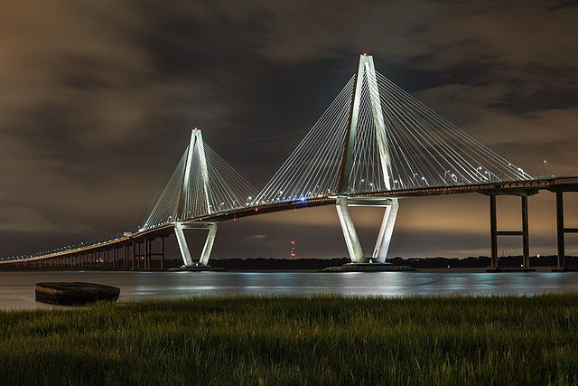
English: Arthur Ravenel Jr. Bridge (also known as the Cooper River Bridge) at night, looking northwest from Mount Pleasant, South Carolina. |
| Ǹgụ́ụ̀bọ̀chị̀ | |
| Mkpọlọ́gwụ̀ | Orü ọnwé |
| Odé ákwụ́kwọ́ | Juliancolton |
| Nke ya ozor |
.jpg)
|

| Camera location | | View this and other nearby images on: OpenStreetMap |
|---|
Nkwényé
I, the copyright holder of this work, hereby publish it under the following license:
This file is licensed under the Creative Commons Attribution-Share Alike 4.0 International license.
- I wepulara nóru:
- i nye – ikọpị,ikekasi na izịpụ ọru a
- i dowaria – igbanwee ọrụ a
- Ọ ga bụ na ọnọdụ ndi a:
- í-kpó-áhà – Ị ga-enyerịrị ugo kwesịrị ekwesị, nye njikọ na ikikere ahụ, ma gosikwa ma emere mgbanwe. Ị nwere ike ime ya n'ụzọ ezi uche ọ bụla, mana ọ bụghị n'ụzọ ọ bụla na-egosi na onye nyere ikikere kwadoro gị maọbụ ojiji gị.
- gbásàa kà – Ọ bụrụ na ị tụgharịgharịa, gbanwee, ma ọ bụ wulite n'elu ihe ahụ, ị ga-ekesa ndenye gị n'okpuru otu ma ọ bụ ikike dakọtara dị ka nke mbụ.
This image has been assessed using the Quality image guidelines and is considered a Quality image.
|
Ịta nke usòrò
Bìri èhì/ogè k'ị hụ òtù ụ̀fa dị̀ m̀gbè ahụ̀.
| Èhì/Ogè | Mbọ-aka | Ógólógó na asaá | Òjìème | Nkwute | |
|---|---|---|---|---|---|
| dị ùgbu â | 18:24, 5 Maachị 2017 | | 6,038 × 4,025 (9.63 MB) | Juliancolton | rv self, I like the previous version better |
| 18:23, 5 Maachị 2017 |  | 5,687 × 3,791 (9.46 MB) | Juliancolton | crop | |
| 03:10, 27 Febụwarị 2017 |  | 6,038 × 4,025 (9.63 MB) | Juliancolton | User created page with UploadWizard |
Ojiji faịlụ
Ihe ndị na-eso ihe eji Ihu akwụkwọ eme na faịlụ a:
Ejiji failụ zụrụ ọha
Wikis ndi a edeputara na eji kwa failụ a:
- Ihe eji na af.wikipedia.org
- Ihe eji na ar.wikipedia.org
- Ihe eji na ary.wikipedia.org
- Ihe eji na arz.wikipedia.org
- Ihe eji na ast.wikipedia.org
- Ihe eji na ca.wikipedia.org
- Ihe eji na cs.wikipedia.org
- Ihe eji na cy.wikipedia.org
- Ihe eji na dag.wikipedia.org
- Ihe eji na de.wikipedia.org
- Ihe eji na de.wikivoyage.org
- Ihe eji na diq.wikipedia.org
- Ihe eji na en.wikipedia.org
- Ihe eji na eo.wikipedia.org
- Ihe eji na es.wikipedia.org
- Ihe eji na eu.wikipedia.org
- Ihe eji na fa.wikipedia.org
- Ihe eji na fr.wikipedia.org
- Ihe eji na fr.wikinews.org
- Ihe eji na fr.wikivoyage.org
- Ihe eji na ga.wikipedia.org
- Ihe eji na glk.wikipedia.org
- Ihe eji na gl.wikipedia.org
- Ihe eji na ha.wikipedia.org
- Ihe eji na he.wikipedia.org
- Ihe eji na hi.wikipedia.org
- Ihe eji na ht.wikipedia.org
- Ihe eji na hy.wikipedia.org
- Ihe eji na ia.wikipedia.org
- Ihe eji na id.wikipedia.org
- Ihe eji na it.wikipedia.org
- Ihe eji na ku.wikipedia.org
- Ihe eji na mg.wikipedia.org
- Ihe eji na mhr.wikipedia.org
- Ihe eji na nn.wikipedia.org
- Ihe eji na oc.wikipedia.org
- Ihe eji na os.wikipedia.org
- Ihe eji na pap.wikipedia.org
- Ihe eji na pl.wikipedia.org
- Ihe eji na pt.wikipedia.org
Lee more global usage of this file.