
Usòrò:ZimbabweOMC.png
Otu nyochaa a ha:724 × 600 piksels Ndị ọzọ mkpebi:290 × 240 piksels | 579 × 480 piksels | 939 × 778 piksels.
Failụ si na nke mbu (939 × 778 pixel, ívù akwukwo orunótu: 36 KB, MIME nke: image/png)
Mmẹkụwátá
| Nkówá |
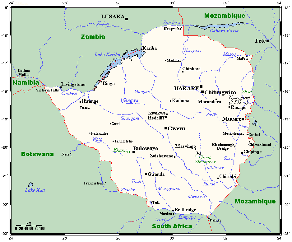
English: A map showing Zimbabwe's cities, main towns, selected villages, rivers, selected archaeological sites and its highest peak. This map's source is here, with the uploader's modifications, and the GMT homepage says that the tools are released under the GNU General Public License. |
| Ǹgụ́ụ̀bọ̀chị̀ | 17 Julaị 2008 (original upload date) |
| Mkpọlọ́gwụ̀ | Transferred from en.wikipedia to Commons. |
| Odé ákwụ́kwọ́ | Kelisi at Bekee Wikipedia |
Nkwényé
Kelisi from en.wikipedia.org, the copyright holder of this work, hereby publishes it under the following license:
| Edebere faịlụ a n'okpuru ikikeree Creative Commons Attribution-Share Alike 3.0 Unported license. Subject to disclaimers. | ||
| Í-kpó-áhà: Kelisi from en.wikipedia.org | ||
| ||
| This licensing tag was added to this file as part of the GFDL licensing update. |

|
Í nwèrèíkí jé, gbạsáa na/ma í mezí akwukwo nka na okpúrù íwú GNU Ákwúkwó Íwú nke Owéré, Nké 1.2 ma nke íchè ndi Free Software Foundation; wéfùtàrà; na adighi nkejị di íchẹ, adighi édé nke Ihú-Ihü Ákwúkwó, na adighi Ázú-Ihü Ákwúkwó. Ákwúkwó iwu hé jéré jé di na nkeji kpóró GNU Ákwúkwó Íwú nke Owéré". Subject to disclaimers. |
Original upload log
The original description page was here. All following user names refer to en.wikipedia.
- 2008-07-17 01:11 Kelisi 939×778× (36803 bytes) == Summary == A map showing Zimbabwe's cities, main towns, selected villages, rivers, selected archaeological sites and its highest peak. This map's source is [http://www.aquarius.ifm-geomar.de/ here], with the uploader's modifications, and the [http://gm
Ịta nke usòrò
Bìri èhì/ogè k'ị hụ òtù ụ̀fa dị̀ m̀gbè ahụ̀.
| Èhì/Ogè | Mbọ-aka | Ógólógó na asaá | Òjìème | Nkwute | |
|---|---|---|---|---|---|
| dị ùgbu â | 07:28, 23 Disemba 2011 | | 939 × 778 (36 KB) | Urdangaray | {{Information |Description={{en|A map showing Zimbabwe's cities, main towns, selected villages, rivers, selected archaeological sites and its highest peak. This map's source is [http://www.aquarius.ifm-geomar.de/ here], with the uploader's modifications, |
Ojiji faịlụ
Ihe ndị na-eso ihe eji Ihu akwụkwọ eme na faịlụ a:
Ejiji failụ zụrụ ọha
Wikis ndi a edeputara na eji kwa failụ a:
- Ihe eji na csb.wikipedia.org
- Ihe eji na cs.wikipedia.org
- Ihe eji na el.wikipedia.org
- Ihe eji na en.wikipedia.org
- Ihe eji na es.wikipedia.org
- Ihe eji na fi.wikipedia.org
- Ihe eji na ka.wikipedia.org
- Ihe eji na mg.wikipedia.org
- Ihe eji na ru.wikipedia.org
- Ihe eji na uk.wikipedia.org