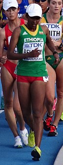
Faịlụ:Bydgoszcz 2016 IAAF World U20 Championships, 10000m walk women19 19-07-2016.jpg
Page contents not supported in other languages.
Ọdịdị
Shí Wikipedia, njikotá édémédé nke onyobulạ

Otu nyochaa a ha:800 × 600 piksels Ndị ọzọ mkpebi:320 × 240 piksels | 640 × 480 piksels | 1,024 × 768 piksels | 1,280 × 960 piksels | 1,440 × 1,080 piksels.
Failụ si na nke mbu (1,440 × 1,080 pixel, ívù akwukwo orunótu: 497 KB, MIME nke: image/jpeg)
Failụ a si na Wikimedia Commons,enwekwara ike iji ya eme ihe na arụmarụ ọzọ. Nkọwa na ihuakwukwọ nkọwa failụ eziri na okpuru.
Mmẹkụwátá
| NkówáBydgoszcz 2016 IAAF World U20 Championships, 10000m walk women19 19-07-2016.jpg |
Polski: Mistrzostwa Świata Juniorów w Lekkoatletyce U20 w Bydgoszczy 2016; chód na 10000 m kobiet
English: 2016 IAAF World U20 Championships in Bydgoszcz, 10000m walk women |
|||
| Ǹgụ́ụ̀bọ̀chị̀ | ||||
| Mkpọlọ́gwụ̀ | Orü ọnwé | |||
| Odé ákwụ́kwọ́ | Pit1233 | |||
| Nke ya ozor |
|
| Camera location | 53° 08′ 48.11″ N, 18° 01′ 13.98″ E | View this and other nearby images on: OpenStreetMap |
|---|
Nkwényé
I, the copyright holder of this work, hereby publish it under the following license:
| This file is made available under the Creative Commons CC0 1.0 Universal Public Domain Dedication. | |
| The person who associated a work with this deed has dedicated the work to the public domain by waiving all of their rights to the work worldwide under copyright law, including all related and neighboring rights, to the extent allowed by law. You can copy, modify, distribute and perform the work, even for commercial purposes, all without asking permission.
http://creativecommons.org/publicdomain/zero/1.0/deed.enCC0Creative Commons Zero, Public Domain Dedicationfalsefalse |
Nkowapụta
Tinye nkọwa otu ahịrị ihe faịlụ a na-anochi anya ya.
Ihe ndị egosiri na faịlụ a
depicts Bekee
Teresa Zurek Bekee
Ụfọdụ uru na-enweghị ihe Wikidata
copyright status Bekee
copyrighted Bekee
19 Julaị 2016
53°8'48.113"N, 18°1'13.984"E
source of file Bekee
captured with Bekee
Sony DSC-HX50V Bekee
exposure time Bekee
0.004 second
f-number Bekee
6.3
focal length Bekee
128.07 millimetre
ISO speed Bekee
250
image/jpeg
checksum Bekee
76e16a1d41ee9b77a234cf739682c9acd05d8ccf
data size Bekee
509,149 byte
1,080 pixel
width Bekee
1,440 pixel
Ịta nke usòrò
Bìri èhì/ogè k'ị hụ òtù ụ̀fa dị̀ m̀gbè ahụ̀.
| Èhì/Ogè | Mbọ-aka | Ógólógó na asaá | Òjìème | Nkwute | |
|---|---|---|---|---|---|
| dị ùgbu â | 20:47, 28 Septemba 2016 |  | 1,440 × 1,080 (497 KB) | Pit1233 | User created page with UploadWizard |
Ojiji faịlụ
Ọdighi ihuakwụkwọ nwere failụ a.
Ómárí nso
Usòrò á nwèrè ụmà nke ozor, ọ ga dí na ȯ byàrà shí nsé nhuunuche nsónùsòrò mà ihe njè nsónùsòrò nke kéré mà nké tonyèrè ya na nsónùsòrò.
Ȯ bụ nà usòrò à gabnwere shí òtù ȯ di nà mgbe mbu, ótù ụmà àgághị è zí ya.
| Mmewe igwefoto | SONY |
|---|---|
| Njirimara mmepụta igwefoto | DSC-HX50V |
| Exposure time | sec 1/250 (0.004) |
| Ónúọgụgụ F | f/6.3 |
| ISO speed rating | 250 |
| Ụbọchi na oge emepụtara ngwa mmụta | 18:19, 19 Julaị 2016 |
| Lens focal length | 128.07 mm |
| Latitude | 53° 8′ 48.11″ N |
| Longitude | 18° 1′ 13.98″ E |
| Altitude | 45.4 meters above sea level |
| Ívú nà àsáa | Nkịtị |
| Mkpebi gbara uhie | 350 dpi |
| Mkpebi kwụọ ọtọ | 350 dpi |
| Ndiriusòrò ejìème | PictureProject 1.7.0 W |
| Failụ mgbanwe ụbọchi na oge | 16:24, 27 Septemba 2016 |
| Y and C positioning | Centered |
| Exposure Program | Landscape mode (for landscape photos with the background in focus) |
| Ùdị Exif | 2.3 |
| Date and time of digitizing | 18:19, 19 Julaị 2016 |
| Meaning of each component |
|
| Ọ̀chạ́ APEX | 7.78671875 |
| APEX exposure bias | 0 |
| Maximum land aperture | 5.3125 APEX (f/6.3) |
| Metering mode | Nnòmi |
| Mkpọlógwù ìfè | Nke námaghị |
| Gbu fịàfịà | Flash did not fire, compulsory flash suppression |
| Supported Flashpix version | 1 |
| Ámá àgwà | sRGB |
| Mkpọ̀lọ́gwụ̀ usòrò | Digital still camera |
| Scene type | A directly photographed image |
| Custom image processing | Normal process |
| Exposure mode | Auto exposure |
| White balance | Auto white balance |
| Digital zoom ratio | 1 |
| Scene capture type | Mkpọlógwù'àlà |
| Contrast | Nkịtị |
| Saturation | Nkịtị |
| Sharpness | Nkịtị |
| GPS time (atomic clock) | 16:19 |
| Receiver status | Measurement in progress |
| Measurement mode | 3-dimensional measurement |
| Measurement precision | Poor (1.3099) |
| Speed unit | Kilometers per hour |
| Speed of GPS receiver | 3.168 |
| Reference for direction of movement | True direction |
| Direction of movement | 169.63 |
| Geodetic survey data used | WGS-84 |
| GPS tag version | 0.0.3.2 |

