Jump to content

Faịlụ:Hawaje.jpg

Page contents not supported in other languages.
Shí Wikipedia, njikotá édémédé nke onyobulạ

Failụ si na nke mbu (3,600 × 2,800 pixel, ívù akwukwo orunótu: 1.16 MB, MIME nke: image/jpeg)

Failụ a si na Wikimedia Commons,enwekwara ike iji ya eme ihe na arụmarụ ọzọ. Nkọwa na ihuakwukwọ nkọwa failụ eziri na okpuru.

Mmẹkụwátá

Nkówá
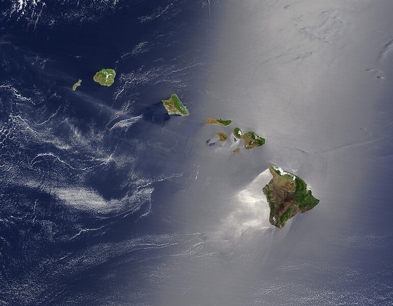
English: Satellite view of Hawaii archipellago (USA).

Original description from NASA:

"A silver swath of sunglint surrounds half of the Hawaiian islands in this true-color Terra MODIS image acquired on May 27, 2003. Sunglint reveals turbulence in the surface waters of the Pacific Ocean. If the surface of the water was as smooth as a perfect mirror, we would see the circle of the Sun as a perfect reflection. But because the surface of the water is ruffled with waves, each wave acts like a mirror and the Sun’s reflection gets softened into a broader silver swath, called the sunglint region.

"In this scene, the winds ruffling the water surface around the Hawaiian Islands create varying patterns, leaving some areas calmer than others. Southwest of Hawaii and Maui, on their leeward sides, calmer waters are indicated by brighter silver coloration. Conversely, notice how most of the vegetation on the Hawaiian Islands grows on their northeastern, or windward, sides.

"From lower right to upper left, the “Big Island” (Hawaii), Maui, Kahoolawe, Lanai, Molokai, Oahu, Kauai, and Niihau islands all make up the state of Hawaii, which lies more than 2,000 miles from any other part of the United States. The small red dot on the Big Island’s southeastern side marks a hot spot on Kilauea Volcano’s southern flank. Kilauea has been erupting almost continuously since January 1983, and is one of the world’s best studied volcanoes."
Français : Vue satellite de l'archipel d'Hawaï (États-Unis).
Ǹgụ́ụ̀bọ̀chị̀
Mkpọlọ́gwụ̀ NASA. Image courtesy Jacques Descloitres, MODIS Land Rapid Response Team at NASA GSFC. (IotD Date: 2003-06-03. IotD ID: 15304)
Odé ákwụ́kwọ́ Jacques Descloitres
Nke ya ozor
Modified version
This is a retouched picture, which means that it has been digitally altered from its original version. Modifications: cloned out and healed little red line on the big island. The original can be viewed here: Hawaje.jpg. Modifications made by IdLoveOne.

Derivative works

Derivative works of this file:  Hawaje-NoRedLine.jpg

Nkwényé

Public domain This file is in the public domain in the United States because it was solely created by NASA. NASA copyright policy states that "NASA material is not protected by copyright unless noted". (See Template:PD-USGov, NASA copyright policy page or JPL Image Use Policy.)
Warnings:

Nkowapụta

Tinye nkọwa otu ahịrị ihe faịlụ a na-anochi anya ya.

Ihe ndị egosiri na faịlụ a

depicts Bekee

Ịta nke usòrò

Bìri èhì/ogè k'ị hụ òtù ụ̀fa dị̀ m̀gbè ahụ̀.

Èhì/OgèMbọ-akaÓgólógó na asaáÒjìèmeNkwute
dị ùgbu â18:19, 26 Ọktoba 2005NvóÁká màkà otù ȯ dị nà 18:19, 26 Ọktoba 20053,600 × 2,800 (1.16 MB)PalladinusHawaii Islands

Ọdighi ihuakwụkwọ nwere failụ a.

Ejiji failụ zụrụ ọha

Wikis ndi a edeputara na eji kwa failụ a:

Ómárí nso