
Usòrò:AnneFrankHouseAmsterdamtheNetherlands.jpg

Otu nyochaa a ha:390 × 599 piksels Ndị ọzọ mkpebi:156 × 240 piksels | 312 × 480 piksels | 500 × 768 piksels | 666 × 1,024 piksels | 1,333 × 2,048 piksels | 2,562 × 3,936 piksels.
Failụ si na nke mbu (2,562 × 3,936 pixel, ívù akwukwo orunótu: 7.8 MB, MIME nke: image/jpeg)
This image has been assessed using the Quality image guidelines and is considered a Quality image.
|

|
This image has been assessed under the valued image criteria and is considered the most valued image on Commons within the scope: Anne Frank House. You can see its nomination here. |
Mmẹkụwátá
| Nkówá |
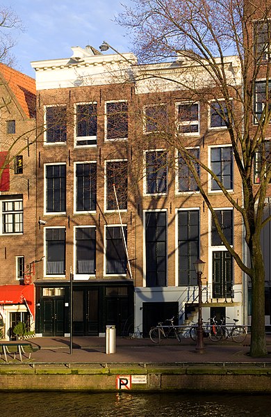
English: The Anne Frank House alongside the Prinsengracht in Amsterdam, the Netherlands.
Nederlands: Het Anne Frank Huis aan de Prinsengracht in Amsterdam, Nederland.
Français : La maison d'Anne Frank sur Prinsengracht à Amsterdam, Pays-Bas. |
| Ǹgụ́ụ̀bọ̀chị̀ | |
| Mkpọlọ́gwụ̀ | Orü ọnwé |
| Odé ákwụ́kwọ́ | Massimo Catarinella |
| Ọdà (Í jí kwá usòrò nke) |
See license, attribution required - contact me to discuss less restrictive commercial licensing terms by email Special:EmailUser/Massimo Catarinella or leave a message on my talk page |
| Nke ya ozor | Derivative works of this file: AnneFrankHouseAmsterdamtheNetherlands edit1.jpg |
| Camera location | | View this and other nearby images on: OpenStreetMap |
|---|
Nkwényé
I, the copyright holder of this work, hereby publish it under the following license:
Edebere faịlụ a n'okpuru ikikeree Creative Commons Attribution-Share Alike 3.0 Unported license.
- I wepulara nóru:
- i nye – ikọpị,ikekasi na izịpụ ọru a
- i dowaria – igbanwee ọrụ a
- Ọ ga bụ na ọnọdụ ndi a:
- í-kpó-áhà – Ị ga-enyerịrị ugo kwesịrị ekwesị, nye njikọ na ikikere ahụ, ma gosikwa ma emere mgbanwe. Ị nwere ike ime ya n'ụzọ ezi uche ọ bụla, mana ọ bụghị n'ụzọ ọ bụla na-egosi na onye nyere ikikere kwadoro gị maọbụ ojiji gị.
- gbásàa kà – Ọ bụrụ na ị tụgharịgharịa, gbanwee, ma ọ bụ wulite n'elu ihe ahụ, ị ga-ekesa ndenye gị n'okpuru otu ma ọ bụ ikike dakọtara dị ka nke mbụ.
Ịta nke usòrò
Bìri èhì/ogè k'ị hụ òtù ụ̀fa dị̀ m̀gbè ahụ̀.
| Èhì/Ogè | Mbọ-aka | Ógólógó na asaá | Òjìème | Nkwute | |
|---|---|---|---|---|---|
| dị ùgbu â | 16:24, 25 Ọgọọst 2009 | | 2,562 × 3,936 (7.8 MB) | Massimo Catarinella | sRGB |
| 23:45, 19 Eprel 2009 |  | 2,562 × 3,936 (7.31 MB) | Massimo Catarinella | Now I've also corrected the horizontal perspective. | |
| 18:40, 8 Maachị 2009 |  | 1,422 × 2,200 (3.12 MB) | Massimo Catarinella | {{Information |Description={{en|1=The Anne Frank House in Amsterdam, the Netherlands.}} {{nl|1=Het Anne Frank Huis in Amsterdam, Nederland.}} |Source=Own work by uploader |Author=Massimo Catarinella |Date=8 March 2009 |Permiss |
Ojiji faịlụ
Ọdighi ihuakwụkwọ nwere failụ a.
Ejiji failụ zụrụ ọha
Wikis ndi a edeputara na eji kwa failụ a:
- Ihe eji na ar.wikipedia.org
- Ihe eji na ast.wikipedia.org
- Ihe eji na as.wikipedia.org
- Ihe eji na ca.wikipedia.org
- Ihe eji na ckb.wikipedia.org
- Ihe eji na cs.wikipedia.org
- Ihe eji na da.wikipedia.org
- Ihe eji na el.wikipedia.org
- Ihe eji na en.wikipedia.org
- Ihe eji na en.wikivoyage.org
- Ihe eji na es.wikipedia.org
- Ihe eji na et.wikipedia.org
- Ihe eji na eu.wikipedia.org
- Ihe eji na fr.wikipedia.org
- Ihe eji na fr.wikivoyage.org
- Ihe eji na ga.wikipedia.org
- Ihe eji na gl.wikipedia.org
- Ihe eji na he.wikipedia.org
- Ihe eji na hr.wikipedia.org
- Ihe eji na id.wikipedia.org
- Ihe eji na it.wikivoyage.org
- Ihe eji na ko.wikipedia.org
- Ihe eji na mr.wikipedia.org
- Ihe eji na ms.wikipedia.org
- Ihe eji na nl.wikipedia.org
- Ihe eji na no.wikipedia.org
- Ihe eji na pl.wikipedia.org
- Ihe eji na ro.wikipedia.org
- Ihe eji na si.wikipedia.org
- Ihe eji na sr.wikipedia.org
Lee more global usage of this file.