
Usòrò:Fiji location map.svg

Size of this PNG preview of this SVG file: 467 × 599 piksels. Ndị ọzọ mkpebi:187 × 240 piksels | 374 × 480 piksels | 599 × 768 piksels | 798 × 1,024 piksels | 1,596 × 2,048 piksels | 728 × 934 piksels.
Failụ si na nke mbu (usòrò SVG, nà áhà pixel 728 × 934, ívụ usòrò: 144 KB)
Mmẹkụwátá
| Nkówá |
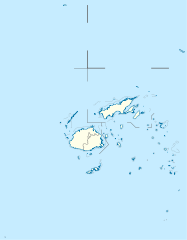
Deutsch: Positionskarte von Fidschi
Quadratische Plattkarte, N-S-Streckung 104 %. Geographische Begrenzung der Karte:
English: Location map of Fiji
Equirectangular projection, N/S stretching 104 %. Geographic limits of the map:
|
| Ǹgụ́ụ̀bọ̀chị̀ | |
| Mkpọlọ́gwụ̀ |
Orü ọnwé, using
|
| Odé ákwụ́kwọ́ | NordNordWest |
| Ọdà (Í jí kwá usòrò nke) |
I, the copyright holder of this work, hereby publish it under the following license: Edebere faịlụ a n'okpuru ikikeree Creative Commons Attribution-Share Alike 3.0 Unported license.
|
| Nke ya ozor |
Derivative works of this file: |


|
This map has been made or improved in the German Kartenwerkstatt (Map Lab). You can propose maps to improve as well.
|
Ịta nke usòrò
Bìri èhì/ogè k'ị hụ òtù ụ̀fa dị̀ m̀gbè ahụ̀.
| Èhì/Ogè | Mbọ-aka | Ógólógó na asaá | Òjìème | Nkwute | |
|---|---|---|---|---|---|
| dị ùgbu â | 10:19, 19 Septemba 2011 | | 728 × 934 (144 KB) | NordNordWest | corr |
| 16:04, 11 Ọktoba 2009 |  | 728 × 934 (218 KB) | NordNordWest | {{int:filedesc}} {{Information |Description= {{de|Positionskarte von Fidschi}} Quadratische Plattkarte, N-S-Streckung 104 %. Geographische Begrenzung der Karte: * N: 12.3° S * S: 21.8° S * W: 174.4° O * O: 177.9° W {{en|Location map of |
Ojiji faịlụ
Ọdighi ihuakwụkwọ nwere failụ a.
Ejiji failụ zụrụ ọha
Wikis ndi a edeputara na eji kwa failụ a:
- Ihe eji na af.wikipedia.org
- Ihe eji na an.wikipedia.org
- Ihe eji na ar.wikipedia.org
- Ihe eji na arz.wikipedia.org
- Ihe eji na ast.wikipedia.org
- Ihe eji na azb.wikipedia.org
- Ihe eji na az.wikipedia.org
- Ihe eji na ba.wikipedia.org
- Ihe eji na be-tarask.wikipedia.org
- Ihe eji na be.wikipedia.org
- Ihe eji na bg.wikipedia.org
Lee more global usage of this file.