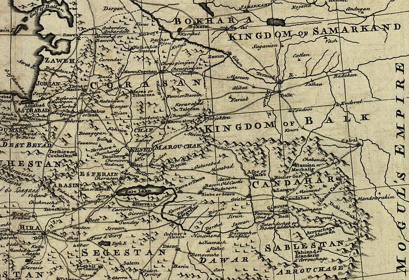
Usòrò:Map of Afghanistan during the Safavid and Moghul Empire.jpg

Otu nyochaa a ha:800 × 548 piksels Ndị ọzọ mkpebi:320 × 219 piksels | 640 × 439 piksels | 1,024 × 702 piksels | 1,280 × 878 piksels | 2,532 × 1,736 piksels.
Failụ si na nke mbu (2,532 × 1,736 pixel, ívù akwukwo orunótu: 1.16 MB, MIME nke: image/jpeg)
Ịta nke usòrò
Bìri èhì/ogè k'ị hụ òtù ụ̀fa dị̀ m̀gbè ahụ̀.
| Èhì/Ogè | Mbọ-aka | Ógólógó na asaá | Òjìème | Nkwute | |
|---|---|---|---|---|---|
| dị ùgbu â | 02:50, 2 Maachị 2011 |  | 2,532 × 1,736 (1.16 MB) | Officer | {{Information |Description= |Source= |Date= |Author= |Permission= |other_versions= }} |
| 02:42, 2 Maachị 2011 |  | 2,342 × 1,682 (1.04 MB) | Officer | {{Information |Description= |Source= |Date= |Author= |Permission= |other_versions= }} | |
| 02:32, 2 Maachị 2011 |  | 2,402 × 1,599 (1.02 MB) | Officer | {{Information |Description= |Source= |Date= |Author= |Permission= |other_versions= }} | |
| 01:37, 2 Maachị 2011 |  | 2,064 × 1,607 (856 KB) | Officer | {{Information |Description= |Source= |Date= |Author= |Permission= |other_versions= }} | |
| 14:39, 12 Maachị 2010 |  | 1,810 × 1,810 (915 KB) | Officer | {{Information |Description=Map of Afghanistan during the Safavid and Mughal Empire, from the 16th century to 1747 when the current nation-state was created. |Source=[http://memory.loc.gov/ The Library of Congress, American Memory] - [http://memory.loc.gov | |
| 03:48, 21 Jenụwarị 2010 |  | 2,056 × 1,574 (983 KB) | Officer | {{Information |Description=Map of Afghanistan during the Safavid and Mughal Empire, from the 16th century to 1747 when the current nation-state was created. |Source=[http://memory.loc.gov/ The Library of Congress, American Memory] - [http://memory.loc.gov | |
| 01:29, 19 Novemba 2009 |  | 1,679 × 1,678 (790 KB) | Officer | {{Information |Description=Map of Afghanistan during the Safavid and Mughal Empire, from the 16th century to 1747 when the current nation-state was created. |Source=[http://memory.loc.gov/ The Library of Congress, American Memory] - [http://memory.loc.gov |
Ojiji faịlụ
Ọdighi ihuakwụkwọ nwere failụ a.
Ejiji failụ zụrụ ọha
Wikis ndi a edeputara na eji kwa failụ a:
- Ihe eji na ar.wikipedia.org
- Ihe eji na azb.wikipedia.org
- Ihe eji na az.wikipedia.org
- Ihe eji na bn.wikipedia.org
- Ihe eji na el.wikipedia.org
- Ihe eji na en.wikipedia.org
- Ihe eji na fa.wikipedia.org
- Ihe eji na hi.wikipedia.org
- Ihe eji na id.wikipedia.org
- Ihe eji na it.wikipedia.org
- Ihe eji na ja.wikipedia.org
- Ihe eji na nl.wikipedia.org
- Ihe eji na no.wikipedia.org
- Ihe eji na pnb.wikipedia.org
- Ihe eji na pt.wikipedia.org
- Ihe eji na ru.wikipedia.org
- Ihe eji na ta.wikipedia.org
- Ihe eji na te.wikipedia.org
- Ihe eji na tg.wikipedia.org
- Ihe eji na uk.wikipedia.org
- Ihe eji na ur.wikipedia.org
- Ihe eji na www.wikidata.org
Lee more global usage of this file.


