
Usòrò:Roque Agando, Parque nacional de Garajonay, La Gomera, España, 2012-12-14, DD 01.jpg
Failụ si na nke mbu (4,649 × 3,153 pixel, ívù akwukwo orunótu: 6.6 MB, MIME nke: image/jpeg)
Mmẹkụwátá
| Nkówá |
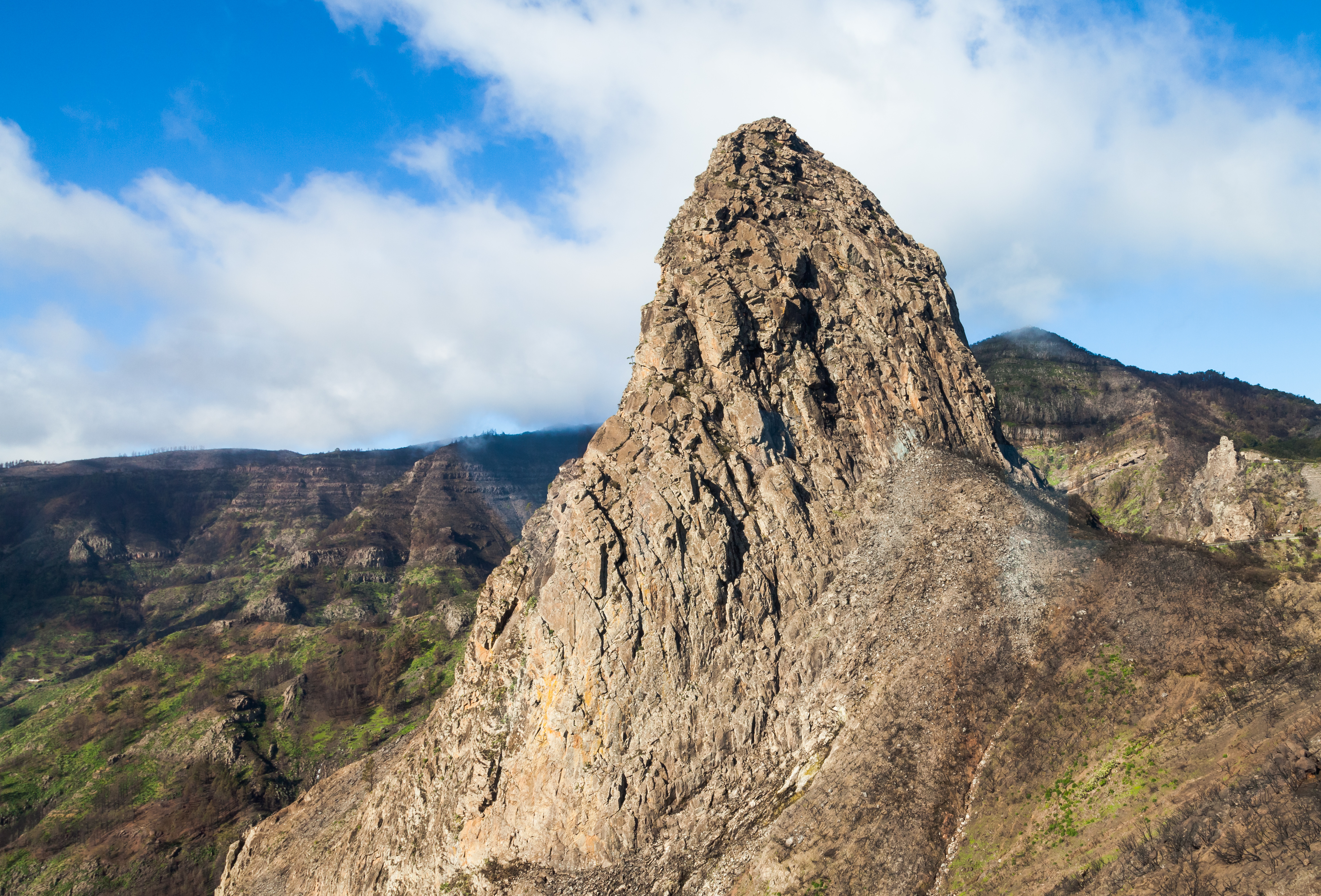
English: Roque Agando (Agando rock) belongs to the Garajonay National Park (UNESCO World Heritage Site) and is not far from San Sebastián de la Gomera, capital of the island of La Gomera, Canary Islands, Spain. This 1251 m high volcanic plug is one of the landmarks of the island and has a prominence of 180 m (220 m from the south side).
Español: Roque Agando pertenece al Parque Nacional de Garajonay (Patrimonio de la Humanidad de la UNESCO) y se encuentra en las proximidades de San Sebastián de la Gomera, capital de la isla de La Gomera, Islas Canarias, España. Este cuello volcánico cuyo pico se encuentra a una altura de 1251 m es uno de los símbolos de la isla y tiene una prominencia de 180 m (220 desde la parte sur).
Français : Le rocher d'Agando (Roque Agando), dans le parc national de Garajonay de l'île de La Gomera dans les Îles Canaries, en Espagne. Ce parc est classé Patrimoine mondial par l'Unesco. Le rocher se trouve près de la capitale de l'île, San Sebastián de la Gomera. Ce pic volcanique, qui culmine à 1251 m, est un des symboles de l'île. Il s'élève à 180 mètres au-dessus du sol environnant, et jusqu'à 220 mètres dans sa partie sud.
Bosanski: Stijena "Roque Agando" pripada Nacionalnom parku Garajonay i mjesto je UNESCO-ve svjetske baštine nedaleko od grada San Sebastián de la Gomera na ostrvu La Gomera, Kanarska ostrva, Španija
Čeština: Skalní formace Roque Agando, patřící do národního parku Garajonay National Park na ostrově La Gomera, Kanárské ostrovy, Španělsko.
Magyar: A Roque Agando (Agando szikla) az UNESCO Világörökség részét képező Garajonay Nemzeti Parkban, nem messze San Sebastián de la Gomeratól, La Gomera fővárosától. Ez az 1251 méter magas, a szigetből 180 méterre kiemelkedő vulkanikus képződmény a sziget egyik jelképe (Kanári-szigetek, Spanyolország)
Italiano: La Roque de Agando, un collo vulcanico nel Parco nazionale di Garajonay nelle Isole Canarie in Spagna.
한국어: 세계유산인 가라호나이 국립공원에 속하는 아간도 바위는 스페인령 카나리아 제도의 라고메라 섬의 중심 도시인 산세바스티안 데 라고메라에서 그리 멀지 않다. 이 1,251 m 높이의 화산전은 라고메라섬의 랜드마크 중 하나이며, 상대높이가 180 m (남쪽으로부터는 220 m) 에 달한다.
Македонски: Карпата Агандо во националниот парк „Гарахонај“ (светско наследство на УНЕСКО) недалеку од Сан Себастијан де ла Гомера — главен град на островот Гомера, Канарски Острови. Сместена е на 1.251 м надморска височина и е од вулканско потекло.
Nederlands: De Roque de Agando, een 1251 meter hoge vulkanische plug, in het Nationaal park Garajonay op het Canarische eiland La Gomera. |
||||||||||||||||||||
| Ǹgụ́ụ̀bọ̀chị̀ | |||||||||||||||||||||
| Mkpọlọ́gwụ̀ | Orü ọnwé | ||||||||||||||||||||
| Odé ákwụ́kwọ́ |
|
||||||||||||||||||||

| Object location | | View this and other nearby images on: OpenStreetMap |
|---|
| Camera location | | View this and other nearby images on: OpenStreetMap |
|---|
Assessment
|
This image was selected as picture of the day on Wikimedia Commons for 27 November 2014. It was captioned as follows: English: Roque Agando (Agando rock) belongs to the Garajonay National Park (UNESCO World Heritage Site) and is not far from San Sebastián de la Gomera, capital of the island of La Gomera, Canary Islands, Spain. This 1251 m high volcanic plug is one of the landmarks of the island and has a prominence of 180 m (220 m from the south side). Other languages:
Bosanski: Stijena "Roque Agando" pripada Nacionalnom parku Garajonay i mjesto je UNESCO-ve svjetske baštine nedaleko od grada San Sebastián de la Gomera na ostrvu La Gomera, Kanarska ostrva, Španija Čeština: Skalní formace Roque Agando, patřící do národního parku Garajonay National Park na ostrově La Gomera, Kanárské ostrovy, Španělsko. English: Roque Agando (Agando rock) belongs to the Garajonay National Park (UNESCO World Heritage Site) and is not far from San Sebastián de la Gomera, capital of the island of La Gomera, Canary Islands, Spain. This 1251 m high volcanic plug is one of the landmarks of the island and has a prominence of 180 m (220 m from the south side). Español: Roque Agando pertenece al Parque Nacional de Garajonay (Patrimonio de la Humanidad de la UNESCO) y se encuentra en las proximidades de San Sebastián de la Gomera, capital de la isla de La Gomera, Islas Canarias, España. Este cuello volcánico cuyo pico se encuentra a una altura de 1251 m es uno de los símbolos de la isla y tiene una prominencia de 180 m (220 desde la parte sur). Français : Le rocher d'Agando (Roque Agando), dans le parc national de Garajonay de l'île de La Gomera dans les Îles Canaries, en Espagne. Ce pic volcanique, qui culmine à 1251 m, est un des symboles de l'île. Italiano: La Roque de Agando, un collo vulcanico nel Parco nazionale di Garajonay nelle Isole Canarie in Spagna. Magyar: A Roque Agando (Agando szikla) az UNESCO Világörökség részét képező Garajonay Nemzeti Parkban, nem messze San Sebastián de la Gomeratól, La Gomera fővárosától. Ez az 1251 méter magas, a szigetből 180 méterre kiemelkedő vulkanikus képződmény a sziget egyik jelképe (Kanári-szigetek, Spanyolország) Nederlands: De Roque de Agando, een 1251 meter hoge vulkanische plug, in het Nationaal park Garajonay op het Canarische eiland La Gomera. Македонски: Карпата Агандо во националниот парк „Гарахонај“ (светско наследство на УНЕСКО) недалеку од Сан Себастијан де ла Гомера — главен град на островот Гомера, Канарски Острови. Сместена е на 1.251 м надморска височина и е од вулканско потекло. 한국어: 세계유산인 가라호나이 국립공원에 속하는 아간도 바위는 스페인령 카나리아 제도의 라고메라 섬의 중심 도시인 산세바스티안 데 라고메라에서 그리 멀지 않다. 이 1,251 m 높이의 화산전은 라고메라섬의 랜드마크 중 하나이며, 상대높이가 180 m (남쪽으로부터는 220 m) 에 달한다. |
This image has been assessed using the Quality image guidelines and is considered a Quality image.
|
Nkwényé
| Another one of my pictures: Want to see more works of mine? click here |
Under this condition:
Please, use this work legally fulfilling the terms of the license! Please, let me know if you use this work outside Wikimedia Commons sending me an email on Furthermore, if you:
please, do not hesitate to contact me. |

|
Please do not overwrite the author's version with a modified image without discussing with the author. The author would like to make corrections only from the uncompressed RAW file. This ensures that changes are preserved and are based on the best possible source to achieve a high quality. If you think that changes are required, please, get in touch with the author. Otherwise, you can upload a new image with a different name without overwriting this one. Use {{Derived from}} or {{Extracted from}} for this purpose. |
- I wepulara nóru:
- i nye – ikọpị,ikekasi na izịpụ ọru a
- i dowaria – igbanwee ọrụ a
- Ọ ga bụ na ọnọdụ ndi a:
- í-kpó-áhà – Ị ga-enyerịrị ugo kwesịrị ekwesị, nye njikọ na ikikere ahụ, ma gosikwa ma emere mgbanwe. Ị nwere ike ime ya n'ụzọ ezi uche ọ bụla, mana ọ bụghị n'ụzọ ọ bụla na-egosi na onye nyere ikikere kwadoro gị maọbụ ojiji gị.
- gbásàa kà – Ọ bụrụ na ị tụgharịgharịa, gbanwee, ma ọ bụ wulite n'elu ihe ahụ, ị ga-ekesa ndenye gị n'okpuru otu ma ọ bụ ikike dakọtara dị ka nke mbụ.
Ịta nke usòrò
Bìri èhì/ogè k'ị hụ òtù ụ̀fa dị̀ m̀gbè ahụ̀.
| Èhì/Ogè | Mbọ-aka | Ógólógó na asaá | Òjìème | Nkwute | |
|---|---|---|---|---|---|
| dị ùgbu â | 07:38, 5 Eprel 2014 | | 4,649 × 3,153 (6.6 MB) | Poco a poco | New development, crop, dust spots |
| 10:33, 6 Jenụwarị 2013 |  | 4,652 × 3,265 (5.92 MB) | Poco a poco | User created page with UploadWizard |
Ojiji faịlụ
Ọdighi ihuakwụkwọ nwere failụ a.
Ejiji failụ zụrụ ọha
Wikis ndi a edeputara na eji kwa failụ a:
- Ihe eji na ast.wikipedia.org
- Ihe eji na az.wikipedia.org
- Ihe eji na ban.wikipedia.org
- Ihe eji na be-tarask.wikipedia.org
- Ihe eji na bg.wikipedia.org
- Ihe eji na bn.wikipedia.org
- Ihe eji na ca.wikipedia.org
- Ihe eji na crh.wikipedia.org
- Ihe eji na cs.wikipedia.org
- Ihe eji na cv.wikipedia.org
- Ihe eji na da.wikipedia.org
- Ihe eji na de.wikipedia.org
- Ihe eji na de.wikivoyage.org
- Ihe eji na en.wikipedia.org
- Talk:Garajonay National Park
- Wikipedia:Featured pictures/Places/Landscapes
- User talk:Poco a poco
- User talk:National Names 2000
- Wikipedia:Featured pictures thumbs/47
- Wikipedia:Featured picture candidates/Roque Agando, Parque nacional de Garajonay, La Gomera, España, 2012-12-14, DD 01.jpg
- User talk:National Names 2000/Archive 1
- Wikipedia:Featured picture candidates/December-2014
- Wikipedia:Wikipedia Signpost/2014-12-24/Featured content
- Wikipedia:Picture of the day/March 2017
- Template:POTD/2017-03-27
- Wikipedia:Main Page history/2017 March 27
- Ihe eji na en.wikivoyage.org
- Ihe eji na eo.wikipedia.org
- Ihe eji na es.wikipedia.org
- Ihe eji na fr.wikipedia.org
- Ihe eji na he.wikivoyage.org
- Ihe eji na hu.wikipedia.org
- Ihe eji na hy.wikipedia.org
- Ihe eji na it.wikipedia.org
- Ihe eji na ja.wikipedia.org
Lee more global usage of this file.