
Usòrò:Ancient Egypt map-en.svg

Failụ si na nke mbu (usòrò SVG, nà áhà pixel 1,577 × 3,219, ívụ usòrò: 687 KB)
|
Mmẹkụwátá
| Nkówá |
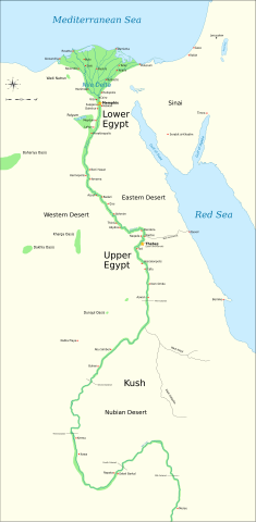
Català: Mapa de l'antic Egipte, que mostra el Nil fins a la cinquena cataracta, i les principals ciutats i llocs del període dinàstic (c. 3150 aC a 30 aC). El Caire i Jerusalem es mostren com a ciutats de referència.
English: Map of Ancient Egypt, showing the Nile up to the fifth cataract, and major cities and sites of the Dynastic period (c. 3150 BC to 30 BC). Cairo and Jerusalem are shown as reference cities. |
| Ǹgụ́ụ̀bọ̀chị̀ | |
| Mkpọlọ́gwụ̀ |
Own work using:
Coordinates:
|
| Odé ákwụ́kwọ́ | Jeff Dahl |
| Nke ya ozor |
File:Ancient Egypt map-en.svg has 5 translations.
Other related versions:[]
|


|
This SVG file contains embedded text that can be translated into your language, using any capable SVG editor, text editor or the SVG Translate tool. For more information see: About translating SVG files. |
This file is translated using SVG <switch> elements. All translations are stored in the same file! Learn more.
For most Wikipedia projects, you can embed the file normally (without a To translate the text into your language, you can use the SVG Translate tool. Alternatively, you can download the file to your computer, add your translations using whatever software you're familiar with, and re-upload it with the same name. You will find help in Graphics Lab if you're not sure how to do this. |
Nkwényé

|
Í nwèrèíkí jé, gbạsáa na/ma í mezí akwukwo nka na okpúrù íwú GNU Ákwúkwó Íwú nke Owéré, Nké 1.2 ma nke íchè ndi Free Software Foundation; wéfùtàrà; na adighi nkejị di íchẹ, adighi édé nke Ihú-Ihü Ákwúkwó, na adighi Ázú-Ihü Ákwúkwó. Ákwúkwó iwu hé jéré jé di na nkeji kpóró GNU Ákwúkwó Íwú nke Owéré". |
- I wepulara nóru:
- i nye – ikọpị,ikekasi na izịpụ ọru a
- i dowaria – igbanwee ọrụ a
- Ọ ga bụ na ọnọdụ ndi a:
- í-kpó-áhà – Ị ga-enyerịrị ugo kwesịrị ekwesị, nye njikọ na ikikere ahụ, ma gosikwa ma emere mgbanwe. Ị nwere ike ime ya n'ụzọ ezi uche ọ bụla, mana ọ bụghị n'ụzọ ọ bụla na-egosi na onye nyere ikikere kwadoro gị maọbụ ojiji gị.
- gbásàa kà – Ọ bụrụ na ị tụgharịgharịa, gbanwee, ma ọ bụ wulite n'elu ihe ahụ, ị ga-ekesa ndenye gị n'okpuru otu ma ọ bụ ikike dakọtara dị ka nke mbụ.
Original upload log
The original description page is/was here. All following user names refer to Commons.
- 2009-01-29 13:21 Bibi Saint-Pol 1577×3219×0 (412000 bytes) (remove wrong text, adjust frame)
- 2009-01-29 12:47 Bibi Saint-Pol 1577×3219×0 (413000 bytes) (added frame)
- 2009-01-29 12:35 Bibi Saint-Pol 1577×3219×0 (412000 bytes) (harmonize colors with the standards + replace unsupported Arial fonts by DejaVu )
- 2008-02-11 06:55 Jeff Dahl 1577×3219×0 (391000 bytes) (sp fx)
- 2007-11-29 02:09 Jeff Dahl 1577×3219×0 (391000 bytes) (Rotate Mediterranean Sea label)
- 2007-11-27 23:32 Jeff Dahl 1577×3219×0 (391000 bytes) (Minor adjustments to Naukratis and Buto)
- 2007-11-27 18:59 Jeff Dahl 1577×3219×0 (391000 bytes) (Cairo and Jerusalem now with black dots/italics)
- 2007-11-23 00:04 Jeff Dahl 1577×3219×0 (391000 bytes) (fx scalebar)
- 2007-11-22 23:56 Jeff Dahl 1577×3219×0 (391000 bytes) ({{Information |Description=A map of ancient Egypt, made with Inkscape |Source=self-made |Date=11-22-07 |Author= Jeff Dahl |Permission= |other_versions={{DerivativeVersions|Ancient Egypt map-ru.svg}} }} )
Ịta nke usòrò
Bìri èhì/ogè k'ị hụ òtù ụ̀fa dị̀ m̀gbè ahụ̀.
| Èhì/Ogè | Mbọ-aka | Ógólógó na asaá | Òjìème | Nkwute | |
|---|---|---|---|---|---|
| dị ùgbu â | 03:39, 20 Ọktoba 2023 | | 1,577 × 3,219 (687 KB) | Haziq Faruqi | File uploaded using svgtranslate tool (https://svgtranslate.toolforge.org/). Added translation for ms. |
| 23:56, 17 Maachị 2022 |  | 1,577 × 3,219 (626 KB) | Manlleus | File uploaded using svgtranslate tool (https://svgtranslate.toolforge.org/). Added translation for ca. | |
| 15:23, 6 Maachị 2022 |  | 1,577 × 3,219 (564 KB) | Scratchinghead | File uploaded using svgtranslate tool (https://svgtranslate.toolforge.org/). Added translation for ta. | |
| 06:03, 25 Febụwarị 2022 |  | 1,577 × 3,219 (564 KB) | Scratchinghead | File uploaded using svgtranslate tool (https://svgtranslate.toolforge.org/). Added translation for ta. | |
| 19:29, 6 Maachị 2020 |  | 1,577 × 3,219 (501 KB) | Nilesh shukla | File uploaded using svgtranslate tool (https://tools.wmflabs.org/svgtranslate/). Added translation for hi. | |
| 11:28, 20 Febụwarị 2009 |  | 1,577 × 3,219 (413 KB) | Bibi Saint-Pol | fix translation mistake on the windrose | |
| 12:13, 30 Jenụwarị 2009 |  | 1,577 × 3,219 (413 KB) | Bibi Saint-Pol | fix position of Nile Delta | |
| 12:21, 29 Jenụwarị 2009 |  | 1,577 × 3,219 (412 KB) | Bibi Saint-Pol | remove wrong text, adjust frame | |
| 12:05, 29 Jenụwarị 2009 |  | 1,577 × 3,219 (413 KB) | Bibi Saint-Pol | {{Assessments|1=Ancient Egypt map.svg|enwiki=1}} __NOTOC__ == {{int:filedesc}} == {{inkscape}} {{Information |Description= {{en|Map of Ancient Egypt, showing the Nile up to the fifth cataract, and major cities and sites of the Dynastic period (c. 3150 BC |
Ojiji faịlụ
Ọdighi ihuakwụkwọ nwere failụ a.
Ejiji failụ zụrụ ọha
Wikis ndi a edeputara na eji kwa failụ a:
- Ihe eji na anp.wikipedia.org
- Ihe eji na azb.wikipedia.org
- Ihe eji na blk.wikipedia.org
- Ihe eji na bn.wikipedia.org
- Ihe eji na bs.wikipedia.org
- Ihe eji na ca.wikipedia.org
- Ihe eji na ceb.wikipedia.org
- Ihe eji na ckb.wikipedia.org
- Ihe eji na cs.wikipedia.org
- Ihe eji na cv.wikipedia.org
- Ihe eji na da.wikipedia.org
- Ihe eji na en.wikipedia.org
- Ancient Egypt
- History of Africa
- Jean-François Champollion
- Old Kingdom of Egypt
- First Intermediate Period of Egypt
- 671 BC
- Wikipedia:WikiProject Former countries
- Cradle of civilization
- Portal:Africa
- Portal:Africa/Featured article
- Portal:Africa/Featured picture
- Portal:Ancient Egypt
- Portal:Ancient Egypt/Selected picture
- Portal talk:Africa/Featured picture
- Africa
- Portal:Maps/Selected picture
- Thinite Confederacy
- Portal:Africa/Featured article/2
- Wikipedia:Featured pictures thumbs/09
- Wikipedia:Picture peer review/Ancient Egypt main map
- Wikipedia:Featured picture candidates/November-2007
- Wikipedia:Featured picture candidates/Ancient Egypt map-en.svg
- Wikipedia:Wikipedia Signpost/2007-12-03/Features and admins
- Portal:Africa/Featured picture/22
- Portal:Maps/Selected picture/32
- User talk:Jeff Dahl/Archive 2
- Portal:Ancient Egypt/Selected picture/2
- User talk:Jeff Dahl/Archive 3
Lee more global usage of this file.