Usòrò:Austin Village OS map 1936 1 2500 25 inch.jpg

Page contents not supported in other languages.
Shí Wikipedia, njikotá édémédé nke onyobulạ

Failụ si na nke mbu(3,720 × 4,272 pixel, ívù akwukwo orunótu: 4.01 MB, MIME nke: image/jpeg)

Failụ a si na Wikimedia Commons,enwekwara ike iji ya eme ihe na arụmarụ ọzọ. Nkọwa na ihuakwukwọ nkọwa failụ eziri na okpuru.

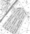
Nkówá Old OS map of Category:Austin Village between Northfield and Longbridge, Birmingham, England. Retouched to remove paper joins.
Ǹgụ́ụ̀bọ̀chị̀
Mkpọlọ́gwụ̀ Ordnance Survey map, 4th edition 25 inch series 1936, scanned by Oosoom
Odé ákwụ́kwọ́ Ordnance Survey (UK)
Ọdà
(Í jí kwá usòrò nke)

none needed

This work is an Ordnance Survey map over 50 years old, which is covered by Crown Copyright which in this case expires 50 years after publication. Ordnance Survey does however ask that they be credited and that the date of publication be given. Any ancillary rights gained through the creation of the electronic version are granted as freely usable under any circumstances.
Public domain
This work created by the United Kingdom Government is in the public domain.

This is because it is one of the following:

  1. It is a photograph taken prior to 1 June 1957; or
  2. It was published prior to 1974; or
  3. It is an artistic work other than a photograph or engraving (e.g. a painting) which was created prior to 1974.

HMSO has declared that the expiry of Crown Copyrights applies worldwide (ref: HMSO Email Reply)
More information.

See also Copyright and Crown copyright artistic works.

Deutsch  English  Español  français  italiano  Nederlands  polski  português  sicilianu  slovenščina  suomi  Türkçe  македонски  русский  українська  മലയാളം  한국어  日本語  简体中文  繁體中文  العربية  +/−

Nkowapụta

Tinye nkọwa otu ahịrị ihe faịlụ a na-anochi anya ya.

Ihe ndị egosiri na faịlụ a

depicts Bekee

image/jpeg

checksum Bekee

3d8c8cb52cf9643c1355903e5dc61205e0ad2e01

data size Bekee

4,200,305 byte

4,272 pixel

width Bekee

3,720 pixel

Ịta nke usòrò

Bìri èhì/ogè k'ị hụ òtù ụ̀fa dị̀ m̀gbè ahụ̀.

Èhì/OgèMbọ-akaÓgólógó na asaáÒjìèmeNkwute
dị ùgbu â14:01, 8 Mee 2009NvóÁká màkà otù ȯ dị nà 14:01, 8 Mee 20093,720 × 4,272 (4.01 MB)Oosoom{{Information |Description=Old OS map of Category:Austin Village between Northfield and Longbridge, Birmingham, England. Retouched to remove paper joins. |Source=Ordn

Ihe ndị na-eso ihe eji Ihu akwụkwọ eme na faịlụ a:

Ejiji failụ zụrụ ọha

Wikis ndi a edeputara na eji kwa failụ a:

Ómárí nso