
Usòrò:Azimuth-Altitude schematic.svg

Size of this PNG preview of this SVG file: 436 × 420 piksels. Ndị ọzọ mkpebi:249 × 240 piksels | 498 × 480 piksels | 797 × 768 piksels | 1,063 × 1,024 piksels | 2,126 × 2,048 piksels.
Failụ si na nke mbu (usòrò SVG, nà áhà pixel 436 × 420, ívụ usòrò: 182 KB)
Mmẹkụwátá
| Nkówá |
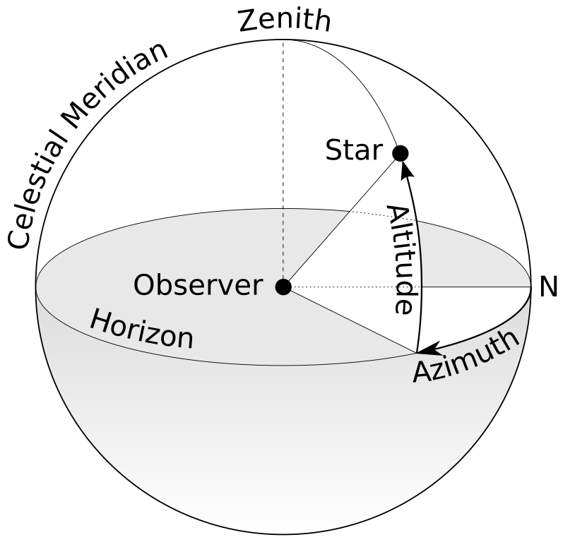
English: A schematic diagram of the terms "Azimuth" and "Altitude" as they relate to the viewing of celestial objects. |
| Mkpọlọ́gwụ̀ | Azimut altitude.svg |
| Odé ákwụ́kwọ́ | TWCarlson |
| Nke ya ozor |
[]
|
| SVG genesis | This diagram was created with Adobe Illustrator, and with Inkscape. This diagram uses embedded text that can be easily translated using a text editor. |


Nkwényé
I, the copyright holder of this work, hereby publish it under the following licenses:
Edebere faịlụ a n'okpuru ikikeree Creative Commons Attribution-Share Alike 3.0 Unported license.
- I wepulara nóru:
- i nye – ikọpị,ikekasi na izịpụ ọru a
- i dowaria – igbanwee ọrụ a
- Ọ ga bụ na ọnọdụ ndi a:
- í-kpó-áhà – Ị ga-enyerịrị ugo kwesịrị ekwesị, nye njikọ na ikikere ahụ, ma gosikwa ma emere mgbanwe. Ị nwere ike ime ya n'ụzọ ezi uche ọ bụla, mana ọ bụghị n'ụzọ ọ bụla na-egosi na onye nyere ikikere kwadoro gị maọbụ ojiji gị.
- gbásàa kà – Ọ bụrụ na ị tụgharịgharịa, gbanwee, ma ọ bụ wulite n'elu ihe ahụ, ị ga-ekesa ndenye gị n'okpuru otu ma ọ bụ ikike dakọtara dị ka nke mbụ.

|
Í nwèrèíkí jé, gbạsáa na/ma í mezí akwukwo nka na okpúrù íwú GNU Ákwúkwó Íwú nke Owéré, Nké 1.2 ma nke íchè ndi Free Software Foundation; wéfùtàrà; na adighi nkejị di íchẹ, adighi édé nke Ihú-Ihü Ákwúkwó, na adighi Ázú-Ihü Ákwúkwó. Ákwúkwó iwu hé jéré jé di na nkeji kpóró GNU Ákwúkwó Íwú nke Owéré". |
Ị nwere ike họrọ ikikere nke masịrị gị.
Ịta nke usòrò
Bìri èhì/ogè k'ị hụ òtù ụ̀fa dị̀ m̀gbè ahụ̀.
| Èhì/Ogè | Mbọ-aka | Ógólógó na asaá | Òjìème | Nkwute | |
|---|---|---|---|---|---|
| dị ùgbu â | 10:02, 7 Maachị 2020 | | 436 × 420 (182 KB) | عبد الجليل 09 | File uploaded using svgtranslate tool (https://tools.wmflabs.org/svgtranslate/). Added translation for es. |
| 11:33, 7 Mee 2012 |  | 436 × 420 (189 KB) | TWCarlson | Reversed image and re-placed text to show proper clockwise direction for measuring azimuth. | |
| 14:09, 19 Disemba 2011 |  | 424 × 419 (182 KB) | TWCarlson | Minor changes | |
| 14:05, 19 Disemba 2011 |  | 424 × 419 (182 KB) | TWCarlson | Minor changes | |
| 13:54, 19 Disemba 2011 |  | 424 × 419 (182 KB) | TWCarlson | Various changes | |
| 13:48, 19 Disemba 2011 |  | 442 × 419 (142 KB) | TWCarlson | {{Information |Description ={{en|1=A schematic diagram of the terms "Azimuth" and "Altitude" as they relate to the viewing of celestial objects.}} |Source =http://commons.wikimedia.org/wiki/File:Azimut_altitude.svg |Author =[[User:TWCar |
Ojiji faịlụ
Ihe ndị na-eso ihe eji Ihu akwụkwọ eme na faịlụ a:
Ejiji failụ zụrụ ọha
Wikis ndi a edeputara na eji kwa failụ a:
- Ihe eji na ast.wikipedia.org
- Ihe eji na ckb.wikipedia.org
- Ihe eji na de.wikipedia.org
- Ihe eji na el.wikipedia.org
- Ihe eji na en.wikipedia.org
- Ihe eji na en.wikibooks.org
- Ihe eji na en.wikiversity.org
- Ihe eji na en.wiktionary.org
- Ihe eji na eu.wikipedia.org
- Ihe eji na fa.wikipedia.org
- Ihe eji na fi.wikipedia.org
- Ihe eji na ga.wikipedia.org
- Ihe eji na hi.wikipedia.org
- Ihe eji na ka.wikipedia.org
- Ihe eji na kbd.wiktionary.org
- Ihe eji na mdf.wikipedia.org
- Ihe eji na ml.wikipedia.org
- Ihe eji na mn.wikipedia.org
- Ihe eji na ms.wikipedia.org
- Ihe eji na ps.wikipedia.org
- Ihe eji na pt.wikipedia.org
- Ihe eji na ro.wikipedia.org
- Ihe eji na sh.wikipedia.org
- Ihe eji na sv.wikipedia.org
- Ihe eji na ta.wiktionary.org
- Ihe eji na te.wikibooks.org
- Ihe eji na tr.wiktionary.org
- Ihe eji na ur.wikipedia.org
- Ihe eji na vec.wikipedia.org
Lee more global usage of this file.