
Usòrò:Bou Craa mine.jpg
Otu nyochaa a ha:459 × 599 piksels Ndị ọzọ mkpebi:184 × 240 piksels | 540 × 705 piksels.
Failụ si na nke mbu (540 × 705 pixel, ívù akwukwo orunótu: 312 KB, MIME nke: image/jpeg)
| Nkówá |
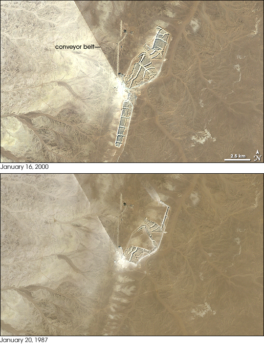
English: Bou Craa phosphate mine, phosphate mine, 100 kilometers (about 60 miles) from the coastal city of El Aaiún, Western Sahara.
NASA image created by Jesse Allen, using Landsat data provided by the United States Geological Survey. |
|||||
| Ǹgụ́ụ̀bọ̀chị̀ | Posted October 5, 2008 | |||||
| Mkpọlọ́gwụ̀ | http://earthobservatory.nasa.gov/IOTD/view.php?id=35524 | |||||
| Odé ákwụ́kwọ́ | NASA Landsat image | |||||
| Ọdà (Í jí kwá usòrò nke) |
|

Ịta nke usòrò
Bìri èhì/ogè k'ị hụ òtù ụ̀fa dị̀ m̀gbè ahụ̀.
| Èhì/Ogè | Mbọ-aka | Ógólógó na asaá | Òjìème | Nkwute | |
|---|---|---|---|---|---|
| dị ùgbu â | 04:26, 4 Maachị 2010 | | 540 × 705 (312 KB) | Tillman | {{Information |Description={{en|1=Bou Craa phosphate mine, phosphate mine, 100 kilometers (about 60 miles) from the coastal city of El Aaiún, Western Sahara. NASA image created by Jesse Allen, using Landsat data provided by the United States Geological |
Ojiji faịlụ
Ihe ndị na-eso ihe eji Ihu akwụkwọ eme na faịlụ a:
Ejiji failụ zụrụ ọha
Wikis ndi a edeputara na eji kwa failụ a:
- Ihe eji na ar.wikipedia.org
- Ihe eji na ca.wikipedia.org
- Ihe eji na ceb.wikipedia.org
- Ihe eji na en.wikipedia.org
- Ihe eji na es.wikipedia.org
- Ihe eji na eu.wikipedia.org
- Ihe eji na fr.wikipedia.org
- Ihe eji na ha.wikipedia.org
- Ihe eji na it.wikipedia.org
- Ihe eji na nl.wikipedia.org
- Ihe eji na pl.wikipedia.org
- Ihe eji na pt.wikipedia.org
- Ihe eji na pt.wikibooks.org
- Ihe eji na ru.wikipedia.org
- Ihe eji na sh.wikipedia.org
- Ihe eji na simple.wikipedia.org
- Ihe eji na ts.wikipedia.org
- Ihe eji na uk.wikipedia.org
- Ihe eji na www.wikidata.org
- Ihe eji na yo.wikipedia.org
- Ihe eji na zh.wikipedia.org
- Ihe eji na zu.wikipedia.org