
Usòrò:Brong Ahafo districts.png

Otu nyochaa a ha:776 × 600 piksels Ndị ọzọ mkpebi:311 × 240 piksels | 621 × 480 piksels | 994 × 768 piksels | 1,056 × 816 piksels.
Failụ si na nke mbu (1,056 × 816 pixel, ívù akwukwo orunótu: 49 KB, MIME nke: image/png)
Mmẹkụwátá
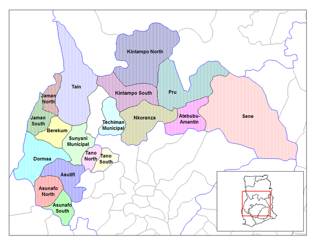
| Nkówá | Map of the districts of the Brong Ahafo region of Ghana. Created by Rarelibra for public domain use. Created using MapInfo Professional v7.5 and various mapping resources. |
| Ǹgụ́ụ̀bọ̀chị̀ | 28 Jụn 2006 (original upload date) |
| Mkpọlọ́gwụ̀ | No machine-readable source provided. Own work assumed (based on copyright claims). |
| Odé ákwụ́kwọ́ | No machine-readable author provided. Ahanta assumed (based on copyright claims). |
Nkwényé
| I, the copyright holder of this work, release this work into the public domain. This applies worldwide. In some countries this may not be legally possible; if so: I grant anyone the right to use this work for any purpose, without any conditions, unless such conditions are required by law. |
Ịta nke usòrò
Bìri èhì/ogè k'ị hụ òtù ụ̀fa dị̀ m̀gbè ahụ̀.
| Èhì/Ogè | Mbọ-aka | Ógólógó na asaá | Òjìème | Nkwute | |
|---|---|---|---|---|---|
| dị ùgbu â | 10:27, 28 Jụn 2006 | | 1,056 × 816 (49 KB) | Ahanta | Map of the districts of the Brong Ahafo region of Ghana. Created by Rarelibra for public domain use. Created using MapInfo Professional v7.5 and various mapping resources. [edit] I, the creator of this work, hereby release it into the public domain. This |
Ojiji faịlụ
Ihe ndị na-eso ihe eji Ihu akwụkwọ eme na faịlụ a:
Ejiji failụ zụrụ ọha
Wikis ndi a edeputara na eji kwa failụ a:
- Ihe eji na ca.wikipedia.org
- Ihe eji na ceb.wikipedia.org
- Ihe eji na dag.wikipedia.org
- Ihe eji na da.wikipedia.org
- Ihe eji na de.wikipedia.org
- Ihe eji na dga.wikipedia.org
- Ihe eji na en.wikipedia.org
- Dormaa District
- Asutifi District
- Nkoranza District
- Sene District
- Atebubu District
- Pru District
- Jaman District
- Berekum-Jaman District
- Kintampo District
- Asunafo District
- User talk:Rarelibra/Maps2
- List of hospitals in Ghana
- List of Ghana Parliament constituencies
- Nsoatre
- User:GerardM/Districts of Ghana
- Tano District, Ghana
- Ihe eji na es.wikipedia.org
- Ihe eji na fa.wikipedia.org
- Ihe eji na frr.wikipedia.org
- Ihe eji na fr.wikipedia.org
Lee more global usage of this file.