
Usòrò:Brumadinho dam catastrophy 2.jpg
Failụ si na nke mbu (2,400 × 1,456 pixel, ívù akwukwo orunótu: 5.35 MB, MIME nke: image/jpeg)
Mmẹkụwátá
| Nkówá |
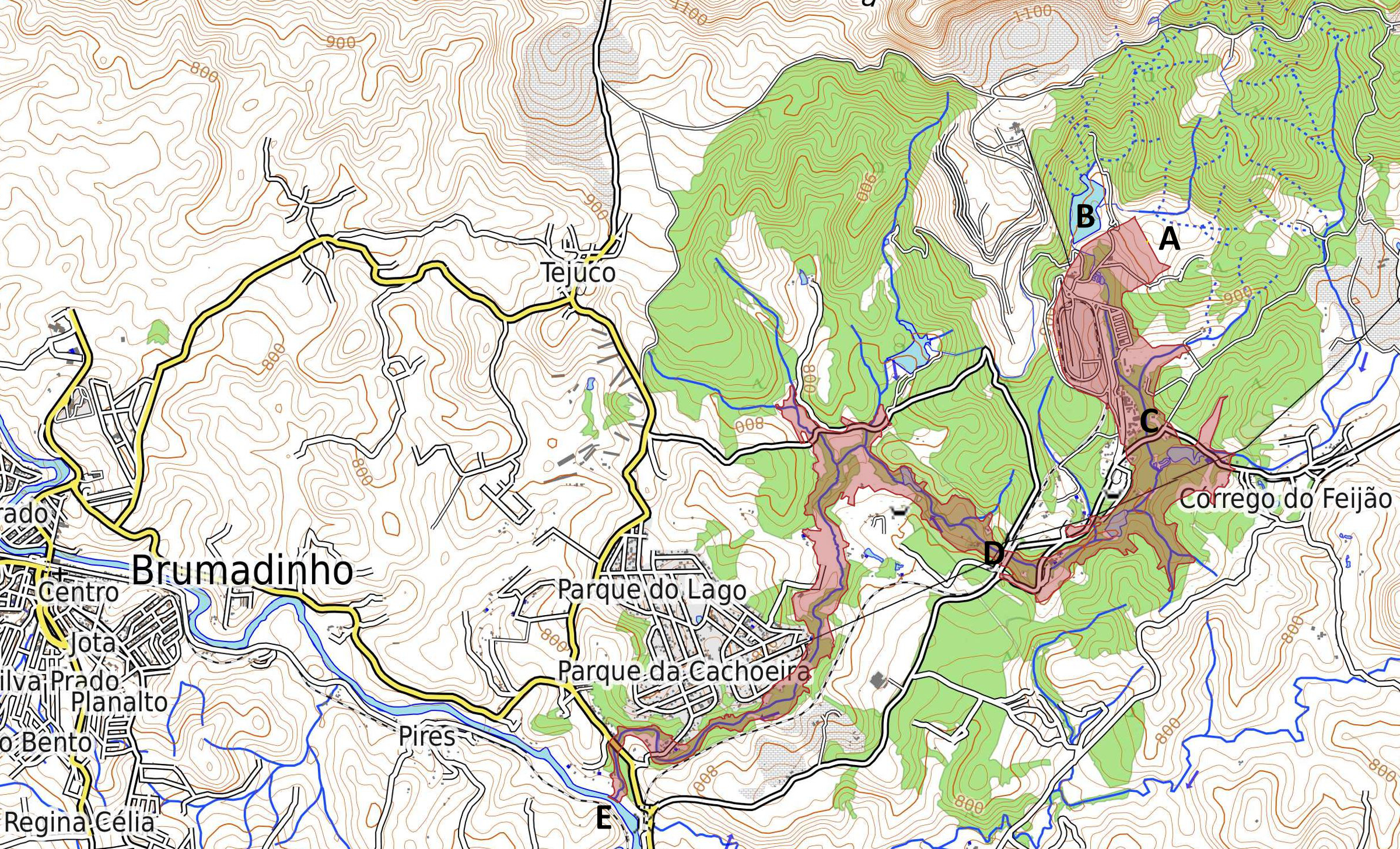
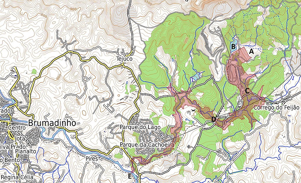
English: Map of tailings dam collapse disaster east of Brumadinho at the Mina Córrego do Feijão. Highlighted in red is the coverage and destruction of the mine dump and debris after the collapse. A Location of destroyed dam and former tailings pond "Barragem I". B Location of second tailings pond "Barragem VI" with destabilized dam, due to the event. C Location of the destroyed office buildings and the cantina of the mine at Vila Ferteco. D Location of the destroyed railway bridge. E Location of the entry point of the mud flood into the river Rio Paraopeba. Português: Mapa da área atingida pelos rejeitos da barragem. A Barragem I - destruída. B Barragem VI - instável. C Vila Ferteco - área administrativa da mina. D Ponte destruída. E Às 15h50min os rejeitos que vazaram da Mina de Feijão atingiram o rio Paraopeba. Deutsch: Karte der Folgen des Dammbruchs bei der Grube Mina Córrego do Feijão östlich des Ortes Brumadinho. In roter Farbe hervorgehoben ist die Bedeckung und Verwüstung durch die Schlammlawine. A Zerstörter Damm des Absetzbeckens "Barragem I". B Benachbartes Absetzbecken "Barragem VI", dessen Damm durch den Vorfall stark beschädigt wurde. C Vila Ferteco - zerstörte Büros und Kantine der Bergbaugesellschaft. D zerstörte Eisenbahnbrücke. E Eintritt der Schlammlawine in den Fluss Paraopeba. |
| Ǹgụ́ụ̀bọ̀chị̀ | |
| Mkpọlọ́gwụ̀ | Map Dataː OpenStreetMap.org contributors. Map styleː OpenTopoMap.org [1] with SRTM data (Shuttle Radar Topography Mission). Shape of mud flow from dam collapseː Sentinel Satellite S2-L1C 2019-01-27 TCI/NDWI/NDVI at sentinel-hub.com via OpenStreetMap.org contributors layer [2] |
| Odé ákwụ́kwọ́ | ESA / Copernicus Sentinel-2A-L1C Satellite and OpenStreetMap.org contributors |
Nkwényé
- I wepulara nóru:
- i nye – ikọpị,ikekasi na izịpụ ọru a
- i dowaria – igbanwee ọrụ a
- Ọ ga bụ na ọnọdụ ndi a:
- í-kpó-áhà – Ị ga-enyerịrị ugo kwesịrị ekwesị, nye njikọ na ikikere ahụ, ma gosikwa ma emere mgbanwe. Ị nwere ike ime ya n'ụzọ ezi uche ọ bụla, mana ọ bụghị n'ụzọ ọ bụla na-egosi na onye nyere ikikere kwadoro gị maọbụ ojiji gị.
- gbásàa kà – Ọ bụrụ na ị tụgharịgharịa, gbanwee, ma ọ bụ wulite n'elu ihe ahụ, ị ga-ekesa ndenye gị n'okpuru otu ma ọ bụ ikike dakọtara dị ka nke mbụ.

|
This image contains data from a satellite in the Copernicus Programme, such as Sentinel-1, Sentinel-2 or Sentinel-3. Attribution is required when using this image.
Í-kpó-áhà: Contains modified Copernicus Sentinel data 2019
The use of Copernicus Sentinel Data is regulated under EU law (Commission Delegated Regulation (EU) No 1159/2013 and Regulation (EU) No 377/2014). Relevant excerpts:
Free access shall be given to GMES dedicated data [...] made available through GMES dissemination platforms [...].
Access to GMES dedicated data [...] shall be given for the purpose of the following use in so far as it is lawful:
GMES dedicated data [...] may be used worldwide without limitations in time.
GMES dedicated data and GMES service information are provided to users without any express or implied warranty, including as regards quality and suitability for any purpose. |
Ịta nke usòrò
Bìri èhì/ogè k'ị hụ òtù ụ̀fa dị̀ m̀gbè ahụ̀.
| Èhì/Ogè | Mbọ-aka | Ógólógó na asaá | Òjìème | Nkwute | |
|---|---|---|---|---|---|
| dị ùgbu â | 20:56, 30 Jenụwarị 2019 | | 2,400 × 1,456 (5.35 MB) | Agricolax | User created page with UploadWizard |
Ojiji faịlụ
Ihe ndị na-eso ihe eji Ihu akwụkwọ eme na faịlụ a:
Ejiji failụ zụrụ ọha
Wikis ndi a edeputara na eji kwa failụ a:
- Ihe eji na cy.wikipedia.org
- Ihe eji na de.wikipedia.org
- Ihe eji na en.wikipedia.org
- Ihe eji na es.wikipedia.org
- Ihe eji na fi.wikipedia.org
- Ihe eji na ga.wikipedia.org
- Ihe eji na he.wikipedia.org
- Ihe eji na hu.wikipedia.org
- Ihe eji na ja.wikipedia.org
- Ihe eji na mk.wikipedia.org
- Ihe eji na pt.wikipedia.org
- Ihe eji na vi.wikipedia.org
- Ihe eji na www.wikidata.org