
Usòrò:Cyclone Favio 22 February 2007 0820Z.jpg

Failụ si na nke mbu (4,400 × 5,600 pixel, ívù akwukwo orunótu: 3.33 MB, MIME nke: image/jpeg)
Mmẹkụwátá
| Nkówá |
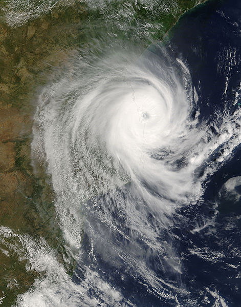
Tropical Cyclone Favio came ashore on the coast of Mozambique in the morning of February 22, 2007. At the time it crossed the shoreline, Favio had lost some strength from its peak the previous day, but still had extremely powerful winds that measured around 203 kilometers per hour (126 miles per hour), according to the Tropical Storm Risk.com and Reuters AlertNet. The cyclone, the strongest recorded storm to hit Mozambique, was heading directly towards the Zambezi River valley region. This region suffered heavy rains associated with the onset of the monsoon, and severe flooding along the Zambezi River in mid-February killed dozens of people and forced more than a hundred thousand people to evacuate, according to reports from the International Federation of Red Cross and Red Crescent Societies posted online by ReliefWeb. This photo-like image was acquired by the Moderate Resolution Imaging Spectroradiometer (MODIS) on the Terra satellite on February 22, 2007, at 10:20 a.m. local time (8:20 UTC), just as the storm was coming ashore. The eye of the storm was just off the coast as MODIS observed the cyclone. Favio had the recognizable shape of a mature, southern hemisphere tropical cyclone, with spiral arms showing its clockwise rotation, and a well-defined eye with strong eyewall (inner ring) clouds. The high-resolution image provided above is at MODIS’ full spatial resolution (level of detail) of 250 meters per pixel. The MODIS Rapid Response System provides this image at additional resolutions. |
|||||
| Ǹgụ́ụ̀bọ̀chị̀ | ||||||
| Mkpọlọ́gwụ̀ | http://earthobservatory.nasa.gov/NaturalHazards/Archive/Feb2007/favio_tmo_2007053_lrg.jpg | |||||
| Odé ákwụ́kwọ́ | NASA image by Jeff Schmaltz, MODIS Rapid Response Team, Goddard Space Flight Center. | |||||
| Ọdà (Í jí kwá usòrò nke) |
|
|||||
| Nke ya ozor | A cropped and annotated version from http://earthobservatory.nasa.gov/NaturalHazards/natural_hazards_v2.php3?img_id=14131 : Image:CycloneFavio 2007Feb22 annotated.jpg. |

Ịta nke usòrò
Bìri èhì/ogè k'ị hụ òtù ụ̀fa dị̀ m̀gbè ahụ̀.
| Èhì/Ogè | Mbọ-aka | Ógólógó na asaá | Òjìème | Nkwute | |
|---|---|---|---|---|---|
| dị ùgbu â | 08:34, 25 Febụwarị 2007 | | 4,400 × 5,600 (3.33 MB) | Irfanfaiz | |
| 20:22, 24 Febụwarị 2007 |  | 4,400 × 5,600 (2.84 MB) | A7x | Tropical Cyclone Favio came ashore on the coast of Mozambique in the morning of February 22, 2007. At the time it crossed the shoreline, Favio had lost some strength from its peak the previous day, but still had extremely powerful winds that measured arou |
Ojiji faịlụ
Ihe ndị na-eso ihe eji Ihu akwụkwọ eme na faịlụ a:
Ejiji failụ zụrụ ọha
Wikis ndi a edeputara na eji kwa failụ a:
- Ihe eji na af.wikipedia.org
- Ihe eji na ca.wikipedia.org
- Ihe eji na en.wikipedia.org
- Ihe eji na fr.wikipedia.org
- Ihe eji na ha.wikipedia.org
- Ihe eji na pt.wikipedia.org
- Ihe eji na ru.wikipedia.org
- Ihe eji na sv.wikipedia.org
- Ihe eji na yo.wikipedia.org