
Usòrò:ET Afar-Tigray border Road to Berhale asv2018-01.jpg

Otu nyochaa a ha:800 × 500 piksels Ndị ọzọ mkpebi:320 × 200 piksels | 640 × 400 piksels | 1,024 × 640 piksels | 1,280 × 800 piksels | 2,560 × 1,600 piksels | 7,834 × 4,896 piksels.
Failụ si na nke mbu (7,834 × 4,896 pixel, ívù akwukwo orunótu: 11.93 MB, MIME nke: image/jpeg)
Mmẹkụwátá
| Nkówá |
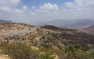
English: Landscape at the border between Tigray and Afar Region, Ethiopia
Русский: Вид в районе границы регионов Тыграй и Афар, Эфиопия |
| Ǹgụ́ụ̀bọ̀chị̀ | |
| Mkpọlọ́gwụ̀ | Orü ọnwé |
| Odé ákwụ́kwọ́ | A.Savin |
| Ọdà (Í jí kwá usòrò nke) |
.svg) Just attribute the author: «A.Savin, Wikipedia»; if you have questions — Telegram, or e-mail to wikiphotospace@gmail.com..svg) Просто укажите в качестве автора: «А.Савин, Википедия»; если есть вопрос — телеграм, или эл.почта на wikiphotospace@gmail.com. Kennzeichnen Sie einfach als Autor: «A.Savin, Wikipedia»; falls Sie Fragen haben — Telegram, oder E-Mail an wikiphotospace@gmail.com.
Thank you. |
| Camera location | | View this and other nearby images on: OpenStreetMap |
|---|
Nkwényé
| Copyleft: This work of art is free; you can redistribute it and/or modify it according to terms of the Free Art License. You will find a specimen of this license on the Copyleft Attitude site as well as on other sites. |
Ịta nke usòrò
Bìri èhì/ogè k'ị hụ òtù ụ̀fa dị̀ m̀gbè ahụ̀.
| Èhì/Ogè | Mbọ-aka | Ógólógó na asaá | Òjìème | Nkwute | |
|---|---|---|---|---|---|
| dị ùgbu â | 13:32, 28 Maachị 2018 | | 7,834 × 4,896 (11.93 MB) | A.Savin | {{User:A.Savin/F |Description= {{en|Landscape at the border between Tigray and Afar Region, Ethiopia}} {{ru|Вид в районе границы регионов Тыграй и Афар, Эфиопия}} |Year=2018 |Country=Ethiopia |Month=01 |Day=26}} {{Location|13|39|21|N|39|49|56.5|E|region:ET-TI}} Category:Taken with Sony ILCE-7RM3 Category:Taken with Sony FE 24-105mm F4 G OSS Category:2018 in Ethiopia Category:Tigray Region Category:Afar Region |
Ojiji faịlụ
Ihe ndị na-eso ihe eji Ihu akwụkwọ eme na faịlụ a:
Ejiji failụ zụrụ ọha
Wikis ndi a edeputara na eji kwa failụ a:
- Ihe eji na ceb.wikipedia.org
- Ihe eji na en.wikipedia.org
- Ihe eji na fr.wikipedia.org
- Ihe eji na ha.wikipedia.org
- Ihe eji na sw.wikipedia.org
- Ihe eji na ts.wikipedia.org
- Ihe eji na www.wikidata.org
- Ihe eji na yo.wikipedia.org
- Ihe eji na zu.wikipedia.org