
Usòrò:GeoServer GeoNetwork with web app.svg

Size of this PNG preview of this SVG file: 685 × 600 piksels. Ndị ọzọ mkpebi:274 × 240 piksels | 548 × 480 piksels | 877 × 768 piksels | 1,169 × 1,024 piksels | 2,339 × 2,048 piksels | 813 × 712 piksels.
Failụ si na nke mbu (usòrò SVG, nà áhà pixel 813 × 712, ívụ usòrò: 103 KB)
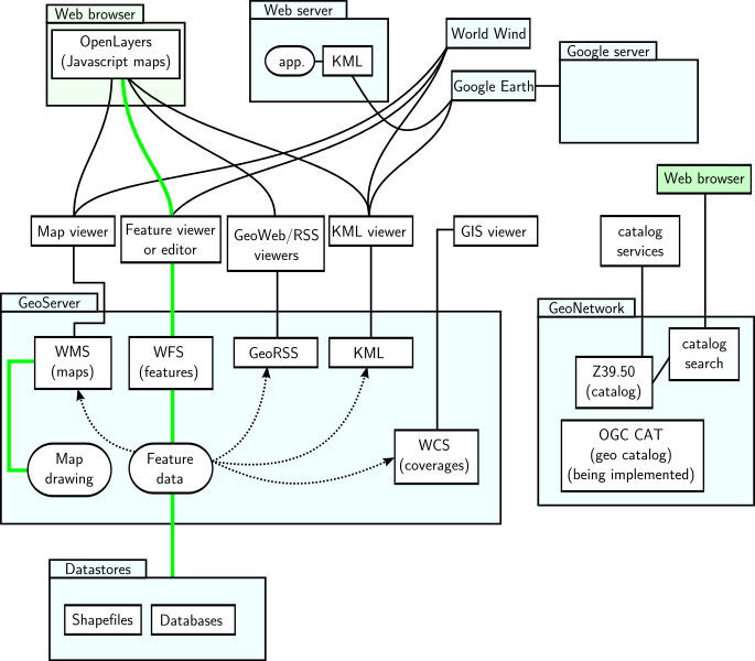
| Nkówá | GeoServer and GeoNetwork with interfaces and applications sketch. Green represents read and write paths. Dotted arrowed line indicates mostly read-only data flow. |
| Ǹgụ́ụ̀bọ̀chị̀ | (UTC) |
| Mkpọlọ́gwụ̀ | |
| Odé ákwụ́kwọ́ |
|
| This is a retouched picture, which means that it has been digitally altered from its original version. Modifications: Made a vector version. The original can be viewed here: GeoServer GeoNetwork with web app.png:
|
I, the copyright holder of this work, hereby publish it under the following licenses:
This file is licensed under the Creative Commons Attribution-Share Alike 3.0 Unported, 2.5 Generic, 2.0 Generic and 1.0 Generic license.
- I wepulara nóru:
- i nye – ikọpị,ikekasi na izịpụ ọru a
- i dowaria – igbanwee ọrụ a
- Ọ ga bụ na ọnọdụ ndi a:
- í-kpó-áhà – Ị ga-enyerịrị ugo kwesịrị ekwesị, nye njikọ na ikikere ahụ, ma gosikwa ma emere mgbanwe. Ị nwere ike ime ya n'ụzọ ezi uche ọ bụla, mana ọ bụghị n'ụzọ ọ bụla na-egosi na onye nyere ikikere kwadoro gị maọbụ ojiji gị.
- gbásàa kà – Ọ bụrụ na ị tụgharịgharịa, gbanwee, ma ọ bụ wulite n'elu ihe ahụ, ị ga-ekesa ndenye gị n'okpuru otu ma ọ bụ ikike dakọtara dị ka nke mbụ.

|
Í nwèrèíkí jé, gbạsáa na/ma í mezí akwukwo nka na okpúrù íwú GNU Ákwúkwó Íwú nke Owéré, Nké 1.2 ma nke íchè ndi Free Software Foundation; wéfùtàrà; na adighi nkejị di íchẹ, adighi édé nke Ihú-Ihü Ákwúkwó, na adighi Ázú-Ihü Ákwúkwó. Ákwúkwó iwu hé jéré jé di na nkeji kpóró GNU Ákwúkwó Íwú nke Owéré". |
Ị nwere ike họrọ ikikere nke masịrị gị.
Original upload log
This image is a derivative work of the following images:
- File:GeoServer_GeoNetwork_with_web_app.png licensed with Cc-by-sa-3.0,2.5,2.0,1.0, GFDL
- 2007-12-07T23:39:23Z SEWilco 698x569 (49691 Bytes) == Summary == {{Information |Description=GeoServer and GeoNetwork with interfaces and applications sketch. Green represents read and write paths. Dotted arrowed line indicates mostly read-only data flow. |Source=self-made |
Uploaded with derivativeFX
Ịta nke usòrò
Bìri èhì/ogè k'ị hụ òtù ụ̀fa dị̀ m̀gbè ahụ̀.
| Èhì/Ogè | Mbọ-aka | Ógólógó na asaá | Òjìème | Nkwute | |
|---|---|---|---|---|---|
| dị ùgbu â | 19:36, 10 Ọgọọst 2013 | | 813 × 712 (103 KB) | Sidpatil | Filesize reduced with `scour`. |
| 06:50, 30 Eprel 2010 |  | 813 × 712 (266 KB) | Andrej Shadura | Fixed fonts issue | |
| 06:42, 30 Eprel 2010 |  | 813 × 712 (250 KB) | Andrej Shadura | {{Information |Description=GeoServer and GeoNetwork with interfaces and applications sketch. Green represents read and write paths. Dotted arrowed line indicates mostly read-only data flow. |Source=*File:GeoServer_GeoNetwork_with_web_app.png |Date |
Ojiji faịlụ
Ihe ndị na-eso ihe eji Ihu akwụkwọ eme na faịlụ a:
Ejiji failụ zụrụ ọha
Wikis ndi a edeputara na eji kwa failụ a:
- Ihe eji na ar.wikipedia.org
- Ihe eji na bn.wikipedia.org
- Ihe eji na de.wikipedia.org
- Ihe eji na en.wikipedia.org
- Ihe eji na es.wikipedia.org
- Ihe eji na fa.wikipedia.org
- Ihe eji na fi.wikipedia.org
- Ihe eji na fr.wikipedia.org
- Ihe eji na gl.wikipedia.org
- Ihe eji na hu.wikipedia.org
- Ihe eji na it.wikipedia.org
- Ihe eji na ja.wikipedia.org
- Ihe eji na ko.wikipedia.org
- Ihe eji na ml.wikipedia.org
- Ihe eji na pl.wikipedia.org
- Ihe eji na ro.wikipedia.org
- Ihe eji na ru.wikipedia.org
- Ihe eji na sr.wikipedia.org
- Ihe eji na uk.wikipedia.org
- Ihe eji na vi.wikipedia.org
- Ihe eji na www.wikidata.org
- Ihe eji na zh.wikipedia.org