
Usòrò:Haiti deforestation.jpg
Otu nyochaa a ha:800 × 600 piksels Ndị ọzọ mkpebi:320 × 240 piksels | 640 × 480 piksels | 1,024 × 768 piksels | 1,280 × 960 piksels | 2,560 × 1,920 piksels.
Failụ si na nke mbu (2,560 × 1,920 pixel, ívù akwukwo orunótu: 1.48 MB, MIME nke: image/jpeg)
| Nkówá |
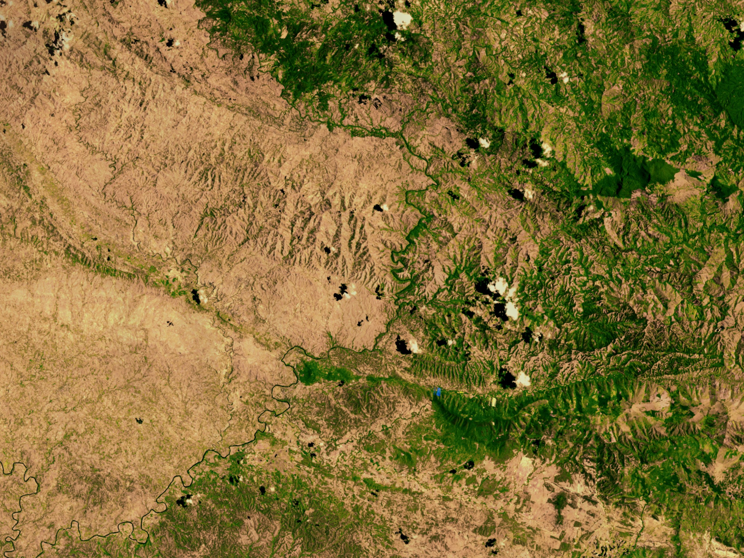
English: Satellite image showing deforestation in Haiti, Haiti-Centre. This image depicts the border between Haiti (left) and the Dominican Republic (right). |
|||||
| Ǹgụ́ụ̀bọ̀chị̀ | ||||||
| Mkpọlọ́gwụ̀ | http://svs.gsfc.nasa.gov/vis/a000000/a002600/a002640/ | |||||
| Odé ákwụ́kwọ́ | NASA | |||||
| Ọdà (Í jí kwá usòrò nke) |
|

| Object location | | View this and other nearby images on: OpenStreetMap |
|---|
Ịta nke usòrò
Bìri èhì/ogè k'ị hụ òtù ụ̀fa dị̀ m̀gbè ahụ̀.
| Èhì/Ogè | Mbọ-aka | Ógólógó na asaá | Òjìème | Nkwute | |
|---|---|---|---|---|---|
| dị ùgbu â | 02:54, 10 Maachị 2008 | | 2,560 × 1,920 (1.48 MB) | Calliopejen | {{Information |Description=Satellite image showing deforestation in Haiti. This image depicts the border between Haiti (left) and the Dominican Republic (right). |Source=http://svs.gsfc.nasa.gov/vis/a000000/a002600/a002640/ |Date=2002-09-25 |Author=NASA | |
Ojiji faịlụ
Ihe ndị na-eso ihe eji Ihu akwụkwọ eme na faịlụ a:
Ejiji failụ zụrụ ọha
Wikis ndi a edeputara na eji kwa failụ a:
- Ihe eji na af.wikipedia.org
- Ihe eji na ar.wikipedia.org
- Ihe eji na ast.wikipedia.org
- Ihe eji na az.wikipedia.org
- Ihe eji na be.wikipedia.org
- Ihe eji na cs.wikipedia.org
- Ihe eji na de.wikipedia.org
- Ihe eji na de.wiktionary.org
- Ihe eji na en.wikipedia.org
- Ihe eji na en.wikinews.org
- Ihe eji na es.wikipedia.org
- Ihe eji na eu.wikipedia.org
- Ihe eji na fa.wikipedia.org
- Ihe eji na fr.wikipedia.org
- Ihe eji na fr.wikiversity.org
- Ihe eji na ht.wikipedia.org
- Ihe eji na kk.wikipedia.org
- Ihe eji na la.wikipedia.org
- Ihe eji na mt.wikipedia.org
- Ihe eji na nn.wikipedia.org
- Ihe eji na no.wikipedia.org
- Ihe eji na oc.wikipedia.org
- Ihe eji na pa.wikipedia.org
- Ihe eji na pl.wikipedia.org
- Ihe eji na pt.wikipedia.org
- Ihe eji na pt.wikibooks.org
- Ihe eji na ru.wikipedia.org
- Ihe eji na te.wikipedia.org
- Ihe eji na uk.wikipedia.org
Lee more global usage of this file.