
Usòrò:Karte Entstehung der Corps.png

Otu nyochaa a ha:566 × 599 piksels Ndị ọzọ mkpebi:227 × 240 piksels | 453 × 480 piksels | 725 × 768 piksels | 967 × 1,024 piksels | 1,830 × 1,938 piksels.
Failụ si na nke mbu (1,830 × 1,938 pixel, ívù akwukwo orunótu: 324 KB, MIME nke: image/png)
Mmẹkụwátá
| Nkówá |
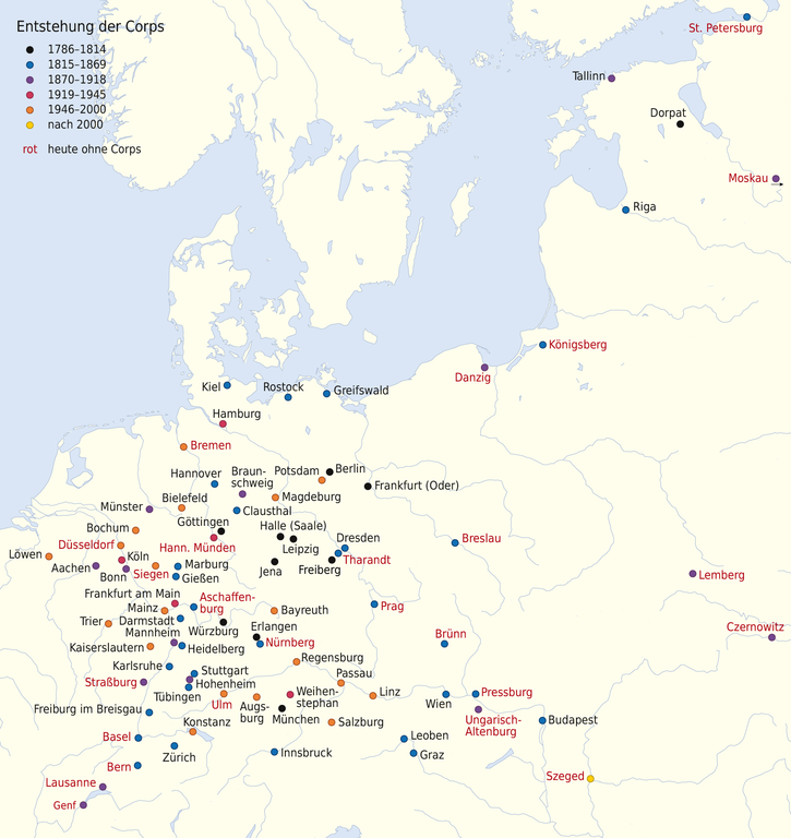
Deutsch: Karte zur Entstehung der Corps
English: Map of the foundations of German Student Corps |
|||
| Ǹgụ́ụ̀bọ̀chị̀ | ||||
| Mkpọlọ́gwụ̀ | ||||
| Odé ákwụ́kwọ́ |
|
|||
| Ọdà (Í jí kwá usòrò nke) |
This file is licensed under the Creative Commons Attribution-Share Alike 3.0 Germany license.
 |
|||
| Nke ya ozor |
|


|
This map has been made or improved in the German Kartenwerkstatt (Map Lab). You can propose maps to improve as well.
|
Nkwényé
This file is licensed under the Creative Commons Attribution-Share Alike 3.0 Germany license.
- I wepulara nóru:
- i nye – ikọpị,ikekasi na izịpụ ọru a
- i dowaria – igbanwee ọrụ a
- Ọ ga bụ na ọnọdụ ndi a:
- í-kpó-áhà – Ị ga-enyerịrị ugo kwesịrị ekwesị, nye njikọ na ikikere ahụ, ma gosikwa ma emere mgbanwe. Ị nwere ike ime ya n'ụzọ ezi uche ọ bụla, mana ọ bụghị n'ụzọ ọ bụla na-egosi na onye nyere ikikere kwadoro gị maọbụ ojiji gị.
- gbásàa kà – Ọ bụrụ na ị tụgharịgharịa, gbanwee, ma ọ bụ wulite n'elu ihe ahụ, ị ga-ekesa ndenye gị n'okpuru otu ma ọ bụ ikike dakọtara dị ka nke mbụ.
Original upload log
This image is a derivative work of the following images:
- File:Europe_laea_location_map.svg licensed with Cc-by-sa-3.0
- 2010-03-10T19:40:39Z Alexrk2 1401x1198 (2313185 Bytes) +San Marino, enh. coastline & countries
- 2010-03-10T18:44:00Z Alexrk2 1401x1198 (1521812 Bytes) == Summary == {{Information |Description= {{de|Positionskarte [[:de:Europa|Europa]]; Politisch mit Staatsgrenzen, Inlandgewässer; Flächentreue Azimutalprojektion}} {{en|Location map [[:en:Europe|Europe]]; Political with sta
Ịta nke usòrò
Bìri èhì/ogè k'ị hụ òtù ụ̀fa dị̀ m̀gbè ahụ̀.
| Èhì/Ogè | Mbọ-aka | Ógólógó na asaá | Òjìème | Nkwute | |
|---|---|---|---|---|---|
| dị ùgbu â | 18:10, 16 Maachị 2015 | | 1,830 × 1,938 (324 KB) | NordNordWest | upd |
| 13:44, 20 Disemba 2014 |  | 1,830 × 1,938 (320 KB) | NordNordWest | upd | |
| 17:13, 25 Ọgọọst 2013 |  | 1,830 × 1,938 (321 KB) | NordNordWest | c | |
| 16:58, 30 Eprel 2013 |  | 1,830 × 1,937 (505 KB) | NordNordWest | upd | |
| 09:18, 23 Eprel 2013 |  | 1,830 × 1,937 (506 KB) | NordNordWest | c | |
| 17:27, 26 Febụwarị 2013 |  | 1,830 × 1,937 (506 KB) | NordNordWest | c | |
| 12:37, 24 Febụwarị 2013 |  | 1,830 × 1,937 (749 KB) | NordNordWest | c | |
| 11:35, 15 Febụwarị 2013 |  | 1,830 × 1,937 (303 KB) | NordNordWest | == {{int:filedesc}} == {{Information |Description= {{de|Karte zur Entstehung der Corps}} {{en|Map of the foundations of German Student Corps}} |Source=*[[:File:Europe_laea_location_map.svg|Europe_laea_location... |
Ojiji faịlụ
Ihe ndị na-eso ihe eji Ihu akwụkwọ eme na faịlụ a:
Ejiji failụ zụrụ ọha
Wikis ndi a edeputara na eji kwa failụ a:
- Ihe eji na en.wikipedia.org
- Ihe eji na et.wikipedia.org
- Ihe eji na fr.wikipedia.org
- Ihe eji na pl.wikipedia.org