
Usòrò:Koppen-Geiger Map Africa present.svg

Size of this PNG preview of this SVG file: 800 × 474 piksels. Ndị ọzọ mkpebi:320 × 190 piksels | 640 × 379 piksels | 1,024 × 607 piksels | 1,280 × 758 piksels | 2,560 × 1,516 piksels | 1,435 × 850 piksels.
Failụ si na nke mbu (usòrò SVG, nà áhà pixel 1,435 × 850, ívụ usòrò: 2.4 MB)
Mmẹkụwátá
| Nkówá |
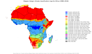
English: Köppen–Geiger climate classification map for Africa
العربية: خريطةٌ مفصّلةٌ تُصنّف أنواع المناخات في مختلفِ مناطق قارّة أفريقيا. |
| Ǹgụ́ụ̀bọ̀chị̀ | |
| Mkpọlọ́gwụ̀ | "Present and future Köppen-Geiger climate classification maps at 1-km resolution". Nature Scientific Data. DOI:10.1038/sdata.2018.214. |
| Odé ákwụ́kwọ́ | Beck, H.E., Zimmermann, N. E., McVicar, T. R., Vergopolan, N., Berg, A., & Wood, E. F. |
Nkwényé
This file is licensed under the Creative Commons Attribution 4.0 International license.
- I wepulara nóru:
- i nye – ikọpị,ikekasi na izịpụ ọru a
- i dowaria – igbanwee ọrụ a
- Ọ ga bụ na ọnọdụ ndi a:
- í-kpó-áhà – Ị ga-enyerịrị ugo kwesịrị ekwesị, nye njikọ na ikikere ahụ, ma gosikwa ma emere mgbanwe. Ị nwere ike ime ya n'ụzọ ezi uche ọ bụla, mana ọ bụghị n'ụzọ ọ bụla na-egosi na onye nyere ikikere kwadoro gị maọbụ ojiji gị.
| Camera location | | View this and other nearby images on: OpenStreetMap |
|---|
Ịta nke usòrò
Bìri èhì/ogè k'ị hụ òtù ụ̀fa dị̀ m̀gbè ahụ̀.
| Èhì/Ogè | Mbọ-aka | Ógólógó na asaá | Òjìème | Nkwute | |
|---|---|---|---|---|---|
| dị ùgbu â | 23:47, 9 Jenụwarị 2020 | | 1,435 × 850 (2.4 MB) | AndreyKva | Optimized using SVGO. |
| 03:32, 26 Novemba 2018 |  | 1,435 × 850 (3.81 MB) | NVergopolan | {{Information |Description={{en| Köppen–Geiger climate classification map for Africa}}|date=2018-11-06|source={{cite journal | title=Present and future Köppen-Geiger climate classification maps at 1-km resolution | journal=Nature Scientific Data |doi=10.1038/sdata.2018.214}}|author=Beck, H.E., Zimmermann, N. E., McVicar, T. R., Vergopolan, N., Berg, A., & Wood, E. F.|permission=|other_versions=|other_fields=}}{{Cc-by-4.0}}{{Location|1.25920455848|19.0676026668}}[[Category:Köppen-Geiger Climat... |
Ojiji faịlụ
Ihe ndị na-eso ihe eji Ihu akwụkwọ eme na faịlụ a:
Ejiji failụ zụrụ ọha
Wikis ndi a edeputara na eji kwa failụ a:
- Ihe eji na ar.wikipedia.org
- Ihe eji na ast.wikipedia.org
- Ihe eji na ee.wikipedia.org
- Ihe eji na en.wikipedia.org
- Ihe eji na es.wikipedia.org
- Ihe eji na fr.wikipedia.org
- Ihe eji na gl.wikipedia.org
- Ihe eji na ha.wikipedia.org
- Ihe eji na lt.wikipedia.org
- Ihe eji na ne.wikipedia.org
- Ihe eji na sl.wikipedia.org
- Ihe eji na sr.wikipedia.org
- Ihe eji na tn.wikipedia.org
- Ihe eji na zh.wikipedia.org