
Usòrò:LLWAS.jpg
Nke káchá mmá na ányá àdíghị.
LLWAS.jpg (640 × 477 pixel, ívù akwukwo orunótu: 30 KB, MIME nke: image/jpeg)
Mmẹkụwátá
| Nkówá |
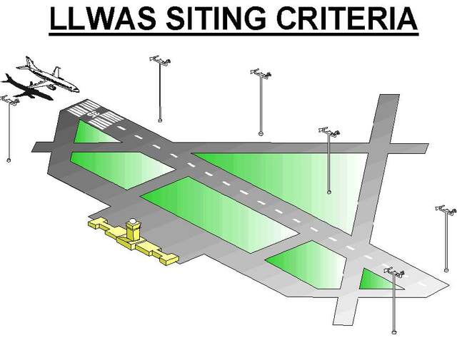
English: Siting of anemometers along a runway for detection of low level wind shears such as microbursts or turbulent crosswinds. |
| Ǹgụ́ụ̀bọ̀chị̀ | |
| Mkpọlọ́gwụ̀ | National Weather Service Aviation Weather Service Program |
| Odé ákwụ́kwọ́ | US Federal Aeronautic Administration (FAA) |
Nkwényé
This image or file is a work of a Federal Aviation Administration employee, taken or made as part of that person's official duties. As a work of the U.S. federal government, the image is in the public domain in the United States.
|
 |
Ịta nke usòrò
Bìri èhì/ogè k'ị hụ òtù ụ̀fa dị̀ m̀gbè ahụ̀.
| Èhì/Ogè | Mbọ-aka | Ógólógó na asaá | Òjìème | Nkwute | |
|---|---|---|---|---|---|
| dị ùgbu â | 23:55, 20 Eprel 2020 | | 640 × 477 (30 KB) | Pierre cb | Uploaded a work by US Federal Aeronautic Administration (FAA) from [https://www.faa.gov/air_traffic/publications/atpubs/aim_html/chap7_section_1.html National Weather Service Aviation Weather Service Program] with UploadWizard |
Ojiji faịlụ
Ihe ndị na-eso ihe eji Ihu akwụkwọ eme na faịlụ a:
Ejiji failụ zụrụ ọha
Wikis ndi a edeputara na eji kwa failụ a:
- Ihe eji na en.wikipedia.org
- Ihe eji na fr.wikipedia.org
- Ihe eji na www.wikidata.org