
Usòrò:MalawiOMC.png

Otu nyochaa a ha:288 × 598 piksels Ndị ọzọ mkpebi:115 × 240 piksels | 500 × 1,039 piksels.
Failụ si na nke mbu (500 × 1,039 pixel, ívù akwukwo orunótu: 31 KB, MIME nke: image/png)
Mmẹkụwátá
| Nkówá | |
| Ǹgụ́ụ̀bọ̀chị̀ | 9 Ọgọọst 2007 (original upload date) |
| Mkpọlọ́gwụ̀ | This map's source is here, with the uploader's (User:Kelisi) modifications. |
| Odé ákwụ́kwọ́ | |
| Ọdà (Í jí kwá usòrò nke) |
Original uploader used GFDL; added CC-by-2.5 as per the licensing of the original source map noted above. |
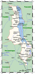
A map showing Malawi sand main towns. This map's source is here, with the uploader's modifications, and the GMT homepage archive copy at the Wayback Machine says that the tools are released under the GNU General Public License.
Nkwényé

|
Í nwèrèíkí jé, gbạsáa na/ma í mezí akwukwo nka na okpúrù íwú GNU Ákwúkwó Íwú nke Owéré, Nké 1.2 ma nke íchè ndi Free Software Foundation; wéfùtàrà; na adighi nkejị di íchẹ, adighi édé nke Ihú-Ihü Ákwúkwó, na adighi Ázú-Ihü Ákwúkwó. Ákwúkwó iwu hé jéré jé di na nkeji kpóró GNU Ákwúkwó Íwú nke Owéré". |
| Edebere faịlụ a n'okpuru ikikeree Creative Commons Attribution-Share Alike 3.0 Unported license. | ||
| ||
| This licensing tag was added to this file as part of the GFDL licensing update. |
Usòrò nke á di okpúrù ákwúkwó íwú nke Mmẹ Òkike Tu ụta Ñkịtị édé íwú nke Í kpó áhà nke Ñkịtị 2.5.
- I wepulara nóru:
- i nye – ikọpị,ikekasi na izịpụ ọru a
- i dowaria – igbanwee ọrụ a
- Ọ ga bụ na ọnọdụ ndi a:
- í-kpó-áhà – Ị ga-enyerịrị ugo kwesịrị ekwesị, nye njikọ na ikikere ahụ, ma gosikwa ma emere mgbanwe. Ị nwere ike ime ya n'ụzọ ezi uche ọ bụla, mana ọ bụghị n'ụzọ ọ bụla na-egosi na onye nyere ikikere kwadoro gị maọbụ ojiji gị.
Original upload log
The original description page was here. All following user names refer to en.wikipedia.
Transferred to Commons using FtCG.
| Èhì/Ogè | Ógólógó na asaá | Òjìème | Nkwute |
|---|---|---|---|
| 16:42, 9 August 2007 | 500 × 1,039 (32,038 bytes) | w:en:Kelisi (ṅkátá | mmetara) | (== Summary == A map showing Malawi's cities and main towns. This map's source is [http://www.aquarius.ifm-geomar.de/ here], with the uploader's modifications, and the [http://gmt.soest.hawaii.edu/ GMT homepage] says that the tools are released under the G) |
Ịta nke usòrò
Bìri èhì/ogè k'ị hụ òtù ụ̀fa dị̀ m̀gbè ahụ̀.
| Èhì/Ogè | Mbọ-aka | Ógólógó na asaá | Òjìème | Nkwute | |
|---|---|---|---|---|---|
| dị ùgbu â | 18:56, 28 Eprel 2012 | | 500 × 1,039 (31 KB) | Darkwind | Transferred from en.wikipedia: see original upload log above |
Ojiji faịlụ
Ihe ndị na-eso ihe eji Ihu akwụkwọ eme na faịlụ a:
Ejiji failụ zụrụ ọha
Wikis ndi a edeputara na eji kwa failụ a:
- Ihe eji na ar.wikipedia.org
- Ihe eji na en.wikipedia.org
- Ihe eji na ha.wikipedia.org
- Ihe eji na tum.wikipedia.org
- Ihe eji na uk.wikipedia.org