
Usòrò:Map of Limpopo with Greater Tubatse highlighted (2011).svg

Size of this PNG preview of this SVG file: 800 × 537 piksels. Ndị ọzọ mkpebi:320 × 215 piksels | 640 × 430 piksels | 1,024 × 687 piksels | 1,280 × 859 piksels | 2,560 × 1,719 piksels | 925 × 621 piksels.
Failụ si na nke mbu (usòrò SVG, nà áhà pixel 925 × 621, ívụ usòrò: 267 KB)
.svg)
Mmẹkụwátá
| Nkówá |
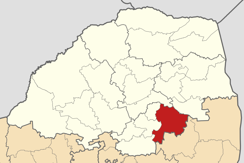
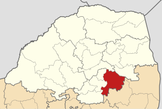
English: Map of municipal boundaries in Limpopo, as they will be after the municipal elections of 18 May 2011, with the Greater Tubatse Local Municipality highlighted in red. Based on File:Map of Limpopo with municipalities blank (2011).svg. |
| Ǹgụ́ụ̀bọ̀chị̀ | |
| Mkpọlọ́gwụ̀ | Orü ọnwé |
| Odé ákwụ́kwọ́ | Htonl |
.svg)
Nkwényé
I, the copyright holder of this work, hereby publish it under the following licenses:

|
Í nwèrèíkí jé, gbạsáa na/ma í mezí akwukwo nka na okpúrù íwú GNU Ákwúkwó Íwú nke Owéré, Nké 1.2 ma nke íchè ndi Free Software Foundation; wéfùtàrà; na adighi nkejị di íchẹ, adighi édé nke Ihú-Ihü Ákwúkwó, na adighi Ázú-Ihü Ákwúkwó. Ákwúkwó iwu hé jéré jé di na nkeji kpóró GNU Ákwúkwó Íwú nke Owéré". |
This file is licensed under the Creative Commons Attribution-Share Alike 4.0 International, 3.0 Unported, 2.5 Generic, 2.0 Generic and 1.0 Generic license.
- I wepulara nóru:
- i nye – ikọpị,ikekasi na izịpụ ọru a
- i dowaria – igbanwee ọrụ a
- Ọ ga bụ na ọnọdụ ndi a:
- í-kpó-áhà – Ị ga-enyerịrị ugo kwesịrị ekwesị, nye njikọ na ikikere ahụ, ma gosikwa ma emere mgbanwe. Ị nwere ike ime ya n'ụzọ ezi uche ọ bụla, mana ọ bụghị n'ụzọ ọ bụla na-egosi na onye nyere ikikere kwadoro gị maọbụ ojiji gị.
- gbásàa kà – Ọ bụrụ na ị tụgharịgharịa, gbanwee, ma ọ bụ wulite n'elu ihe ahụ, ị ga-ekesa ndenye gị n'okpuru otu ma ọ bụ ikike dakọtara dị ka nke mbụ.
Ị nwere ike họrọ ikikere nke masịrị gị.
Ịta nke usòrò
Bìri èhì/ogè k'ị hụ òtù ụ̀fa dị̀ m̀gbè ahụ̀.
| Èhì/Ogè | Mbọ-aka | Ógólógó na asaá | Òjìème | Nkwute | |
|---|---|---|---|---|---|
| dị ùgbu â | 01:11, 14 Mee 2011 | | 925 × 621 (267 KB) | Htonl | == Summary == {{Information |Description ={{en|1=Map of municipal boundaries in w:Limpopo, as they will be after the municipal elections of 18 May 2011, with the [[w:Greater Tubatse Local Municipality|] |
Ojiji faịlụ
Ihe ndị na-eso ihe eji Ihu akwụkwọ eme na faịlụ a:
Ejiji failụ zụrụ ọha
Wikis ndi a edeputara na eji kwa failụ a:
- Ihe eji na de.wikipedia.org
- Ihe eji na en.wikipedia.org
- Ihe eji na ha.wikipedia.org
- Ihe eji na nl.wikipedia.org
- Ihe eji na pl.wikipedia.org
- Ihe eji na sw.wikipedia.org
- Ihe eji na ts.wikipedia.org
- Ihe eji na www.wikidata.org
- Ihe eji na yo.wikipedia.org
- Ihe eji na zu.wikipedia.org
.svg)