
Usòrò:Map of SADC.svg

Size of this PNG preview of this SVG file: 800 × 406 piksels. Ndị ọzọ mkpebi:320 × 162 piksels | 640 × 325 piksels | 1,024 × 520 piksels | 1,280 × 650 piksels | 2,560 × 1,299 piksels | 940 × 477 piksels.
Failụ si na nke mbu (usòrò SVG, nà áhà pixel 940 × 477, ívụ usòrò: 1.31 MB)
Mmẹkụwátá
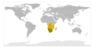
| Nkówá | Map showing SADC-only (yellow) and SACU+SADC (darker) |
| Ǹgụ́ụ̀bọ̀chị̀ | |
| Mkpọlọ́gwụ̀ | Orü ọnwé |
| Odé ákwụ́kwọ́ | Mangwanani |
Nkwényé
| I, the copyright holder of this work, release this work into the public domain. This applies worldwide. In some countries this may not be legally possible; if so: I grant anyone the right to use this work for any purpose, without any conditions, unless such conditions are required by law. |
Ịta nke usòrò
Bìri èhì/ogè k'ị hụ òtù ụ̀fa dị̀ m̀gbè ahụ̀.
| Èhì/Ogè | Mbọ-aka | Ógólógó na asaá | Òjìème | Nkwute | |
|---|---|---|---|---|---|
| dị ùgbu â | 21:47, 20 Ọgọọst 2020 | | 940 × 477 (1.31 MB) | Hogweard | South Sudan border |
| 20:45, 6 Eprel 2008 |  | 940 × 477 (1.3 MB) | Mangwanani | {{Information |Description=Map showing SADC and SACU |Source=self-made |Date=6 April 2008 |Author= Mangwanani |Permission= |other_versions= }} |
Ojiji faịlụ
Ihe ndị na-eso ihe eji Ihu akwụkwọ eme na faịlụ a:
Ejiji failụ zụrụ ọha
Wikis ndi a edeputara na eji kwa failụ a:
- Ihe eji na ca.wikipedia.org
- Ihe eji na ckb.wikipedia.org
- Ihe eji na en.wikipedia.org
- Ihe eji na et.wikipedia.org
- Ihe eji na fa.wikipedia.org
- Ihe eji na id.wikipedia.org
- Ihe eji na it.wikipedia.org
- Ihe eji na mzn.wikipedia.org
- Ihe eji na ta.wiktionary.org
- Ihe eji na www.wikidata.org