
Usòrò:Map of South Africa with Bojanala Platinum highlighted (2011).svg

Size of this PNG preview of this SVG file: 684 × 599 piksels. Ndị ọzọ mkpebi:274 × 240 piksels | 548 × 480 piksels | 876 × 768 piksels | 1,168 × 1,024 piksels | 2,337 × 2,048 piksels | 809 × 709 piksels.
Failụ si na nke mbu (usòrò SVG, nà áhà pixel 809 × 709, ívụ usòrò: 485 KB)
.svg)
Mmẹkụwátá
| Nkówá |
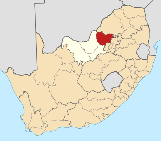
English: Map of district boundaries in South Africa, as they will be after the municipal elections of 18 May 2011, with the Bojanala Platinum District Municipality highlighted in red within the North West in yellow. |
| Ǹgụ́ụ̀bọ̀chị̀ | |
| Mkpọlọ́gwụ̀ | Orü ọnwé |
| Odé ákwụ́kwọ́ | Htonl |
Nkwényé
I, the copyright holder of this work, hereby publish it under the following licenses:

|
Í nwèrèíkí jé, gbạsáa na/ma í mezí akwukwo nka na okpúrù íwú GNU Ákwúkwó Íwú nke Owéré, Nké 1.2 ma nke íchè ndi Free Software Foundation; wéfùtàrà; na adighi nkejị di íchẹ, adighi édé nke Ihú-Ihü Ákwúkwó, na adighi Ázú-Ihü Ákwúkwó. Ákwúkwó iwu hé jéré jé di na nkeji kpóró GNU Ákwúkwó Íwú nke Owéré". |
This file is licensed under the Creative Commons Attribution-Share Alike Attribution-Share Alike 4.0 International, 3.0 Unported, 2.5 Generic, 2.0 Generic and 1.0 Generic license.
- I wepulara nóru:
- i nye – ikọpị,ikekasi na izịpụ ọru a
- i dowaria – igbanwee ọrụ a
- Ọ ga bụ na ọnọdụ ndi a:
- í-kpó-áhà – Ị ga-enyerịrị ugo kwesịrị ekwesị, nye njikọ na ikikere ahụ, ma gosikwa ma emere mgbanwe. Ị nwere ike ime ya n'ụzọ ezi uche ọ bụla, mana ọ bụghị n'ụzọ ọ bụla na-egosi na onye nyere ikikere kwadoro gị maọbụ ojiji gị.
- gbásàa kà – Ọ bụrụ na ị tụgharịgharịa, gbanwee, ma ọ bụ wulite n'elu ihe ahụ, ị ga-ekesa ndenye gị n'okpuru otu ma ọ bụ ikike dakọtara dị ka nke mbụ.
Ị nwere ike họrọ ikikere nke masịrị gị.
Ịta nke usòrò
Bìri èhì/ogè k'ị hụ òtù ụ̀fa dị̀ m̀gbè ahụ̀.
| Èhì/Ogè | Mbọ-aka | Ógólógó na asaá | Òjìème | Nkwute | |
|---|---|---|---|---|---|
| dị ùgbu â | 03:07, 14 Mee 2011 | | 809 × 709 (485 KB) | Htonl | == Summary == {{Information |Description ={{en|1=Map of district boundaries in South Africa, as they will be after the municipal elections of 18 May 2011, with the [[w:Bojanala Platinum District Municipality |
Ojiji faịlụ
Ihe ndị na-eso ihe eji Ihu akwụkwọ eme na faịlụ a:
Ejiji failụ zụrụ ọha
Wikis ndi a edeputara na eji kwa failụ a:
- Ihe eji na af.wikipedia.org
- Rustenburg
- Brits
- Koster
- Hartbeespoort
- Sun City, Noordwes
- Phokeng
- Swartruggens
- De Wildt
- Marikana
- Derby
- Kroondal
- Beestekraal
- Mooinooi
- Sandfontein
- Sjabloonbespreking:Suid-Afrikaanse distriksmunisipaliteit navbox
- Sonop
- Skeerpoort
- Kosmos, Noordwes
- Broederstroom
- Jericho, Noordwes
- Damonsville
- Modderspruit
- Mmakau
- Mabalstad
- Mogwase
- Madikwe
- Mabeskraal
- Dwarsberg
- Goedehoop
- Koffiekraal
- Kraalhoek
- Lesetlheng
- Pella, Noordwes
- Ramokokastad
- Uitkyk, Noordwes
- Saulspoort
- Vleischfontein
- Silwerkrans
- Barseba
- Bethanie, Noordwes
- Freedom Park, Noordwes
- Mankwe
- Wonderkoppies
- Zinniaville
- Makapanstad
- Mathibestad
- Mogogelo
- Syferskuil
- Moretele
- Ihe eji na de.wikivoyage.org
Lee more global usage of this file.
.svg)
.svg)