
Usòrò:Powis Almshouses, Chepstow - geograph.org.uk - 812280.jpg
Nke káchá mmá na ányá àdíghị.
Powis_Almshouses,_Chepstow_-_geograph.org.uk_-_812280.jpg (640 × 426 pixel, ívù akwukwo orunótu: 73 KB, MIME nke: image/jpeg)
|
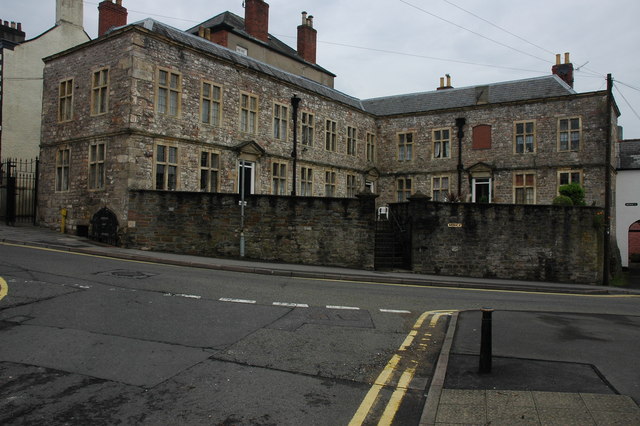
This is a photo of listed building number 2524. |
Mmẹkụwátá
| Nkówá |
English: Powis Almshouses, Chepstow The recently restored red engraved plaque reads:
'THIS ALMS-HOUSE was Erected and Endowed ANNO DOM: 1710 By the sole Charity of THOMAS POWIS late of ENFIELD in the County of Middlesex Vinter. A Native of this Town: For the Reception and Maintenance of Six Poor Men and Six Poor Women. Inhabitants of this Town And Parish For-ever'. Complete with unorthodox letter case. |
| Ǹgụ́ụ̀bọ̀chị̀ | |
| Mkpọlọ́gwụ̀ | From geograph.org.uk |
| Odé ákwụ́kwọ́ | Philip Halling |
| Í-kpó-áhà (required by the license) | Philip Halling / Powis Almshouses, Chepstow / |
| Camera location | | View this and other nearby images on: OpenStreetMap |
|---|
_heading:270.00&language=ig)
| Object location | | View this and other nearby images on: OpenStreetMap |
|---|
_heading:270.00&language=ig)
Nkwényé

|
This image was taken from the Geograph project collection. See this photograph's page on the Geograph website for the photographer's contact details. The copyright on this image is owned by Philip Halling and is licensed for reuse under the Creative Commons Attribution-ShareAlike 2.0 license.
|
Usòrò nke á di okpúrù ákwúkwó íwú nke Mmẹ Òkike Tu ụta Ñkịtị édé íwú nke Í kpó áhà-Í gbàsáa nke Ñkịtị 2.0.
Í-kpó-áhà: Philip Halling
- I wepulara nóru:
- i nye – ikọpị,ikekasi na izịpụ ọru a
- i dowaria – igbanwee ọrụ a
- Ọ ga bụ na ọnọdụ ndi a:
- í-kpó-áhà – Ị ga-enyerịrị ugo kwesịrị ekwesị, nye njikọ na ikikere ahụ, ma gosikwa ma emere mgbanwe. Ị nwere ike ime ya n'ụzọ ezi uche ọ bụla, mana ọ bụghị n'ụzọ ọ bụla na-egosi na onye nyere ikikere kwadoro gị maọbụ ojiji gị.
- gbásàa kà – Ọ bụrụ na ị tụgharịgharịa, gbanwee, ma ọ bụ wulite n'elu ihe ahụ, ị ga-ekesa ndenye gị n'okpuru otu ma ọ bụ ikike dakọtara dị ka nke mbụ.
Ịta nke usòrò
Bìri èhì/ogè k'ị hụ òtù ụ̀fa dị̀ m̀gbè ahụ̀.
| Èhì/Ogè | Mbọ-aka | Ógólógó na asaá | Òjìème | Nkwute | |
|---|---|---|---|---|---|
| dị ùgbu â | 12:56, 20 Febụwarị 2011 | | 640 × 426 (73 KB) | GeographBot | == {{int:filedesc}} == {{Information |description={{en|1=Powis Almshouses, Chepstow The recently restored red engraved plaque reads: 'THIS ALMS-HOUSE was Erected and Endowed ANNO DOM: 1710 By the sole Charity of THOMAS POWIS late of ENFIELD in the |
Ojiji faịlụ
Ihe ndị na-eso ihe eji Ihu akwụkwọ eme na faịlụ a:
Ejiji failụ zụrụ ọha
Wikis ndi a edeputara na eji kwa failụ a:
- Ihe eji na en.wikipedia.org
- Ihe eji na www.wikidata.org