
Usòrò:Red Zone Map-fr.svg

Size of this PNG preview of this SVG file: 800 × 537 piksels. Ndị ọzọ mkpebi:320 × 215 piksels | 640 × 429 piksels | 1,024 × 687 piksels | 1,280 × 858 piksels | 2,560 × 1,717 piksels | 1,421 × 953 piksels.
Failụ si na nke mbu (usòrò SVG, nà áhà pixel 1,421 × 953, ívụ usòrò: 443 KB)
| Nkówá |
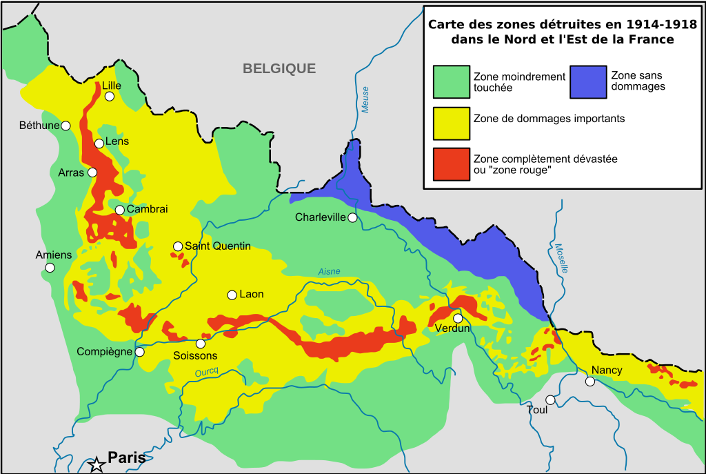
English: Zone rouge Map, describing in red zones completly destroyed by first world war / See also (french) [:http://fr.wikipedia.org/wiki/Zone_rouge_%28s%C3%A9quelles_de_guerre%29 French page of Wikipedia about red zone] La petite carte présente les bassins hydrographiques européens les plus concernés. Cette carte ne vaut que pour la France, mais la Belgique a également été très touchée (d'après Guicherd, J., & Matriot, C. (1921). La terre des régions dévastées'. Journal d'Agriculture Pratique, 34, 154-6.). Français : Cartographie des zones bleues, rouges et jaunes telles que décidées ou négociées après la fin de la Première Guerre mondiale (d'après Guicherd, J., & Matriot, C. (1921). La terre des régions dévastées'. Journal d'Agriculture Pratique, 34, 154-6.). |
| Ǹgụ́ụ̀bọ̀chị̀ | (UTC) |
| Mkpọlọ́gwụ̀ | |
| Odé ákwụ́kwọ́ |
|
| Nke ya ozor | Derivative works of this file: Red Zone Map-de.svg |
| This is a retouched picture, which means that it has been digitally altered from its original version. The original can be viewed here: Zone rougeRed Zone Map.jpg: File:Zone rougeRed Zone Map.jpg.
|
I, the copyright holder of this work, hereby publish it under the following license:
This file is licensed under the Creative Commons Attribution-Share Alike 2.5 Generic license.
- I wepulara nóru:
- i nye – ikọpị,ikekasi na izịpụ ọru a
- i dowaria – igbanwee ọrụ a
- Ọ ga bụ na ọnọdụ ndi a:
- í-kpó-áhà – Ị ga-enyerịrị ugo kwesịrị ekwesị, nye njikọ na ikikere ahụ, ma gosikwa ma emere mgbanwe. Ị nwere ike ime ya n'ụzọ ezi uche ọ bụla, mana ọ bụghị n'ụzọ ọ bụla na-egosi na onye nyere ikikere kwadoro gị maọbụ ojiji gị.
- gbásàa kà – Ọ bụrụ na ị tụgharịgharịa, gbanwee, ma ọ bụ wulite n'elu ihe ahụ, ị ga-ekesa ndenye gị n'okpuru otu ma ọ bụ ikike dakọtara dị ka nke mbụ.
Original upload log
This image is a derivative work of the following images:
- Image:Zone_rougeRed_Zone_Map.jpg licensed with Cc-by-sa-2.5
- 2008-03-13T16:44:02Z Zertrin 1894x1132 (538104 Bytes) {{Information |Description=Zone rouge Map, describing in red zones completly destroyed by first world war / See also (french) [:http://fr.wikipedia.org/wiki/Zone_rouge_%28s%C3%A9quelles_de_guerre%29 French page of Wikipedia
- 2006-12-10T22:49:03Z Lamiot 1894x1132 (511373 Bytes) {{Information |Description= Zone rouge Map, describing in red zones completly destroyed by first world war / See also (french) [:http://fr.wikipedia.org/wiki/Zone_rouge_%28s%C3%A9quelles_de_guerre%29 French page of Wikipedia
Uploaded with derivativeFX
Ịta nke usòrò
Bìri èhì/ogè k'ị hụ òtù ụ̀fa dị̀ m̀gbè ahụ̀.
| Èhì/Ogè | Mbọ-aka | Ógólógó na asaá | Òjìème | Nkwute | |
|---|---|---|---|---|---|
| dị ùgbu â | 15:37, 16 Septemba 2008 | | 1,421 × 953 (443 KB) | Tinodela | {{Information |Description= |Source= |Date= |Author= |Permission= |other_versions= }} |
| 15:36, 16 Septemba 2008 |  | 1,421 × 953 (391 KB) | Tinodela | {{Information |Description=Zone rouge Map, describing in red zones completly destroyed by first world war / See also (french) [:http://fr.wikipedia.org/wiki/Zone_rouge_%28s%C3%A9quelles_de_guerre%29 French page of Wikipedia about red zone] La petite cart |
Ojiji faịlụ
Ihe ndị na-eso ihe eji Ihu akwụkwọ eme na faịlụ a:
Ejiji failụ zụrụ ọha
Wikis ndi a edeputara na eji kwa failụ a:
- Ihe eji na ar.wikipedia.org
- Ihe eji na en.wikipedia.org
- Ihe eji na en.wikivoyage.org
- Ihe eji na fr.wikipedia.org
- Première Guerre mondiale
- Zone rouge (séquelles de guerre)
- Reconstruction en France et en Belgique après la Première Guerre mondiale
- Grande Dépression en France
- Discussion Wikipédia:Wikiconcours/septembre 2008/Équipes/Équipe 4
- Front de l'Ouest (Première Guerre mondiale)
- Wikipédia:Atelier graphique/Cartes/Archives/novembre 2011
- Occupation de la France par l'Allemagne pendant la Première Guerre mondiale
- Ihe eji na he.wikipedia.org
- Ihe eji na it.wikipedia.org
- Ihe eji na ko.wikipedia.org
- Ihe eji na ml.wikipedia.org
- Ihe eji na pl.wikipedia.org
- Ihe eji na pt.wikipedia.org
- Ihe eji na ru.wikipedia.org
- Ihe eji na sr.wikipedia.org
- Ihe eji na sv.wikipedia.org
- Ihe eji na tr.wikipedia.org
- Ihe eji na uk.wikipedia.org
- Ihe eji na www.wikidata.org