
Usòrò:Rudge Farm 3 - geograph.org.uk - 1303923.jpg
Nke káchá mmá na ányá àdíghị.
Rudge_Farm_3_-_geograph.org.uk_-_1303923.jpg (640 × 480 pixel, ívù akwukwo orunótu: 234 KB, MIME nke: image/jpeg)
Mmẹkụwátá
| Nkówá |
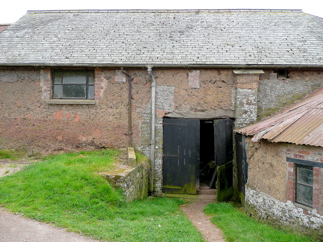
English: Rudge Farm 3 This barn fronting the lane to Morchard Bishop is mediaeval in origin.
The walls are mainly cob - a clay/straw mixture that is very strong if kept dry. The farmer told me that these buildings were all originally thatched. |
| Ǹgụ́ụ̀bọ̀chị̀ | |
| Mkpọlọ́gwụ̀ | From geograph.org.uk |
| Odé ákwụ́kwọ́ | Jonathan Billinger |
| Í-kpó-áhà (required by the license) | Jonathan Billinger / Rudge Farm 3 / |
| Camera location | | View this and other nearby images on: OpenStreetMap |
|---|
_heading:157.00&language=ig)
| Object location | | View this and other nearby images on: OpenStreetMap |
|---|
_heading:157.00&language=ig)
Nkwényé

|
This image was taken from the Geograph project collection. See this photograph's page on the Geograph website for the photographer's contact details. The copyright on this image is owned by Jonathan Billinger and is licensed for reuse under the Creative Commons Attribution-ShareAlike 2.0 license.
|
Usòrò nke á di okpúrù ákwúkwó íwú nke Mmẹ Òkike Tu ụta Ñkịtị édé íwú nke Í kpó áhà-Í gbàsáa nke Ñkịtị 2.0.
Í-kpó-áhà: Jonathan Billinger
- I wepulara nóru:
- i nye – ikọpị,ikekasi na izịpụ ọru a
- i dowaria – igbanwee ọrụ a
- Ọ ga bụ na ọnọdụ ndi a:
- í-kpó-áhà – Ị ga-enyerịrị ugo kwesịrị ekwesị, nye njikọ na ikikere ahụ, ma gosikwa ma emere mgbanwe. Ị nwere ike ime ya n'ụzọ ezi uche ọ bụla, mana ọ bụghị n'ụzọ ọ bụla na-egosi na onye nyere ikikere kwadoro gị maọbụ ojiji gị.
- gbásàa kà – Ọ bụrụ na ị tụgharịgharịa, gbanwee, ma ọ bụ wulite n'elu ihe ahụ, ị ga-ekesa ndenye gị n'okpuru otu ma ọ bụ ikike dakọtara dị ka nke mbụ.
Ịta nke usòrò
Bìri èhì/ogè k'ị hụ òtù ụ̀fa dị̀ m̀gbè ahụ̀.
| Èhì/Ogè | Mbọ-aka | Ógólógó na asaá | Òjìème | Nkwute | |
|---|---|---|---|---|---|
| dị ùgbu â | 14:19, 27 Febụwarị 2011 | | 640 × 480 (234 KB) | GeographBot | == {{int:filedesc}} == {{Information |description={{en|1=Rudge Farm 3 This barn fronting the lane to Morchard Bishop is mediaeval in origin. The walls are mainly cob - a clay/straw mixture that is very strong if kept dry. The farmer told me that these b |
Ojiji faịlụ
Ihe ndị na-eso ihe eji Ihu akwụkwọ eme na faịlụ a:
Ejiji failụ zụrụ ọha
Wikis ndi a edeputara na eji kwa failụ a:
- Ihe eji na en.wikipedia.org
- Ihe eji na zh.wikipedia.org