
Usòrò:Satellite image of Cape Verde in December 2002.jpg

Otu nyochaa a ha:642 × 600 piksels Ndị ọzọ mkpebi:257 × 240 piksels | 514 × 480 piksels | 822 × 768 piksels | 1,189 × 1,111 piksels.
Failụ si na nke mbu (1,189 × 1,111 pixel, ívù akwukwo orunótu: 485 KB, MIME nke: image/jpeg)
| Nkówá |
Español: Imagen satélite de las islas de Cabo Verde
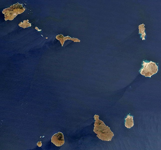
English: satellite image of the Cape Verde Islands
Português: imagem de satélite das ilhas de Cabo Verde |
|||||
| Ǹgụ́ụ̀bọ̀chị̀ | ||||||
| Mkpọlọ́gwụ̀ | Cropped image, original taken from NASA's Visible Earth http://visibleearth.nasa.gov/view_rec.php?id=4638 | |||||
| Odé ákwụ́kwọ́ | NASA's Visible Earth | |||||
| Ọdà (Í jí kwá usòrò nke) |
|

Ịta nke usòrò
Bìri èhì/ogè k'ị hụ òtù ụ̀fa dị̀ m̀gbè ahụ̀.
| Èhì/Ogè | Mbọ-aka | Ógólógó na asaá | Òjìème | Nkwute | |
|---|---|---|---|---|---|
| dị ùgbu â | 14:24, 18 Ọktoba 2008 | | 1,189 × 1,111 (485 KB) | Waldyrious | Reverted to previous version (with consent of the latest version's uploader, see http://commons.wikimedia.org/w/index.php?title=User_talk:JavierMC&diff=15295109&oldid=15294283 ) |
| 01:12, 16 Ọktoba 2008 |  | 1,170 × 1,094 (782 KB) | JavierMC | reduce noise using FFT-iFFT filter and adjust levels for clarity | |
| 17:48, 6 Mee 2008 |  | 1,189 × 1,111 (485 KB) | Waldyrious | less destructive enhancement | |
| 12:25, 16 Eprel 2008 |  | 1,189 × 1,111 (140 KB) | AVM | Color-enhanced version of previous image | |
| 14:32, 26 Disemba 2004 |  | 1,189 × 1,111 (70 KB) | Hautala | {{PD-USGov-NASA}} Satellite image of Cape Verde in December 2002. Cropped image, original taken from NASA's Visible Earth http://visibleearth.nasa.gov/cgi-bin/viewrecord?23101 |
Ojiji faịlụ
Ihe ndị na-eso ihe eji Ihu akwụkwọ eme na faịlụ a:
Ejiji failụ zụrụ ọha
Wikis ndi a edeputara na eji kwa failụ a:
- Ihe eji na af.wikipedia.org
- Ihe eji na ar.wikipedia.org
- Ihe eji na arz.wikipedia.org
- Ihe eji na ast.wikipedia.org
- Ihe eji na ca.wikipedia.org
- Ihe eji na ceb.wikipedia.org
- Ihe eji na dag.wikipedia.org
- Ihe eji na de.wikivoyage.org
- Ihe eji na dga.wikipedia.org
- Ihe eji na diq.wikipedia.org
- Ihe eji na el.wikipedia.org
- Ihe eji na en.wikipedia.org
- Geography of Cape Verde
- Talk:Community of Portuguese Language Countries
- Talk:Henrik Larsson
- Talk:Aristides Pereira
- Talk:Public holidays in Cape Verde
- Talk:Music of Cape Verde
- Talk:Raso lark
- Talk:African Party for the Independence of Guinea and Cape Verde
- Talk:Patrick Vieira
- Talk:Pico do Fogo
- Talk:Flag of Cape Verde
- Talk:Hurricane Alberto (2000)
- Talk:ECOWAS
- Talk:Hurricane Faith
- Talk:Hurricane Allen
- Talk:Santo Antão, Cape Verde
- Talk:Cape Verdean Americans
- Talk:Fogo, Cape Verde
- Talk:Luso-American
- Talk:1901 Atlantic hurricane season
- Talk:Battle of Porto Praya
- Talk:Cape Verdean escudo
- Talk:Lusitanic
- Talk:Effie M. Morrissey
- Talk:Espargos
- Talk:Eco (currency)
- Talk:Tropical Storm Beryl (1982)
- Talk:Portuguese Colonial War
- Talk:Cape Verde hurricane
- Talk:Cape Verdean real
- Talk:Claridade
- Talk:Associação dos Escuteiros de Cabo Verde
- Talk:.cv
Lee more global usage of this file.