
Usòrò:Vegetation.png

Otu nyochaa a ha:800 × 359 piksels Ndị ọzọ mkpebi:320 × 144 piksels | 640 × 287 piksels | 1,385 × 622 piksels.
Failụ si na nke mbu (1,385 × 622 pixel, ívù akwukwo orunótu: 85 KB, MIME nke: image/png)
Mmẹkụwátá
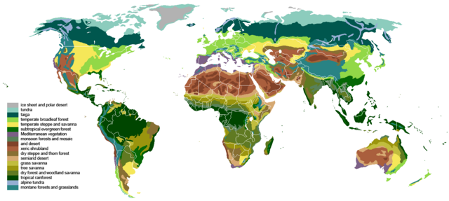
| Nkówá | The main biomes in the world. Drawn by hand using maps. |
| Ǹgụ́ụ̀bọ̀chị̀ | |
| Mkpọlọ́gwụ̀ |
The blank world map in Commons and WSOY Iso karttakirja for the information. Referred to over a hundred sources, but here are some of the more extensively used ones: [1], [2], [3], [4], [5], [6], [7], [8], [9], [10] |
| Odé ákwụ́kwọ́ | Ville Koistinen (user Vzb83) |
| Nke ya ozor |
Derivative works of this file: |
![[5]](https://www.surfaceview.co.uk/storage/image/VMA0018.jpg)
![[6]](https://upload.wikimedia.org/wikipedia/commons/4/4f/Vegetationszonen.png)
![[7]](https://esdac.jrc.ec.europa.eu/images/Eudasm/Africa/images/maps/download/afr_veg.jpg)
![[8]](https://www.researchgate.net/profile/Julie-Morin-9/publication/319979374/figure/fig2/AS:614404802478081@1523496928789/UNESCO-AETFAT-UNSO-Whites-vegetation-map-of-Africa-The-Guineo-Congolian-regional.png)
![[9]](https://www.researchgate.net/profile/Andrea-Kay/publication/276452894/figure/fig1/AS:623557285523457@1525679050775/Map-of-study-area-showing-modern-potential-natural-vegetation-simplified-from-White.png)
![[10]](https://i.pinimg.com/originals/5d/b3/b5/5db3b5b71e47b5467d8df815cd525df5.png)

|
This biogeographical map image could be re-created using vector graphics as an SVG file. This has several advantages; see Commons:Media for cleanup for more information. If an SVG form of this image is available, please upload it and afterwards replace this template with
{{vector version available|new image name}}.
It is recommended to name the SVG file “Vegetation.svg”—then the template Vector version available (or Vva) does not need the new image name parameter. |
Nkwényé
I, the copyright holder of this work, hereby publish it under the following licenses:

|
Í nwèrèíkí jé, gbạsáa na/ma í mezí akwukwo nka na okpúrù íwú GNU Ákwúkwó Íwú nke Owéré, Nké 1.2 ma nke íchè ndi Free Software Foundation; wéfùtàrà; na adighi nkejị di íchẹ, adighi édé nke Ihú-Ihü Ákwúkwó, na adighi Ázú-Ihü Ákwúkwó. Ákwúkwó iwu hé jéré jé di na nkeji kpóró GNU Ákwúkwó Íwú nke Owéré". |
| Edebere faịlụ a n'okpuru ikikeree Creative Commons Attribution-Share Alike 3.0 Unported license. | ||
| ||
| This licensing tag was added to this file as part of the GFDL licensing update. |
This file is licensed under the Creative Commons Attribution-Share Alike 2.5 Generic, 2.0 Generic and 1.0 Generic license.
- I wepulara nóru:
- i nye – ikọpị,ikekasi na izịpụ ọru a
- i dowaria – igbanwee ọrụ a
- Ọ ga bụ na ọnọdụ ndi a:
- í-kpó-áhà – Ị ga-enyerịrị ugo kwesịrị ekwesị, nye njikọ na ikikere ahụ, ma gosikwa ma emere mgbanwe. Ị nwere ike ime ya n'ụzọ ezi uche ọ bụla, mana ọ bụghị n'ụzọ ọ bụla na-egosi na onye nyere ikikere kwadoro gị maọbụ ojiji gị.
- gbásàa kà – Ọ bụrụ na ị tụgharịgharịa, gbanwee, ma ọ bụ wulite n'elu ihe ahụ, ị ga-ekesa ndenye gị n'okpuru otu ma ọ bụ ikike dakọtara dị ka nke mbụ.
Ị nwere ike họrọ ikikere nke masịrị gị.
Ịta nke usòrò
Bìri èhì/ogè k'ị hụ òtù ụ̀fa dị̀ m̀gbè ahụ̀.
| Èhì/Ogè | Mbọ-aka | Ógólógó na asaá | Òjìème | Nkwute | |
|---|---|---|---|---|---|
| dị ùgbu â | 18:55, 24 Maachị 2024 | | 1,385 × 622 (85 KB) | Berkserker | Added more level of detail, particularly to montane and arid regions. Corrections to savannas. |
| 21:44, 18 Septemba 2023 |  | 1,385 × 622 (81 KB) | Berkserker | Minor correction to key | |
| 21:01, 18 Septemba 2023 |  | 1,385 × 622 (80 KB) | Berkserker | Slight correction to Eastern Australia | |
| 09:37, 11 Ọgọọst 2020 |  | 1,385 × 622 (80 KB) | Berkserker | Corrections to Madagascar | |
| 18:35, 6 Ọgọọst 2020 |  | 1,385 × 622 (80 KB) | Berkserker | Minor optimization according to Dyer 2006 | |
| 07:01, 5 Ọgọọst 2020 |  | 1,385 × 622 (80 KB) | Berkserker | Added a third source: Dyer 2006, specifically to address the issues in Eastern USA | |
| 03:40, 15 Jụn 2020 |  | 1,385 × 622 (80 KB) | Berkserker | More corrections as well as fixing remaining dead pixels | |
| 13:22, 9 Jụn 2020 |  | 1,385 × 622 (80 KB) | Berkserker | Further corrections based on the same sources | |
| 07:20, 21 Maachị 2020 |  | 1,385 × 622 (80 KB) | Berkserker | Minor correction to Andean montane forests | |
| 07:09, 21 Maachị 2020 |  | 1,385 × 622 (80 KB) | Berkserker | Fixed key and map colors not matching |
Ojiji faịlụ
Ọdighi ihuakwụkwọ nwere failụ a.
Ejiji failụ zụrụ ọha
Wikis ndi a edeputara na eji kwa failụ a:
- Ihe eji na bh.wikipedia.org
- Ihe eji na bn.wikipedia.org
- Ihe eji na bs.wikipedia.org
- Ihe eji na ckb.wikipedia.org
- Ihe eji na cs.wikipedia.org
- Ihe eji na cv.wikipedia.org
- Ihe eji na el.wikipedia.org
- Ihe eji na en.wikipedia.org
- Ihe eji na en.wikibooks.org
- Ihe eji na et.wikipedia.org
- Ihe eji na eu.wikipedia.org
- Ihe eji na fa.wikipedia.org
- Ihe eji na fr.wikipedia.org
- Ihe eji na hi.wikibooks.org
- Ihe eji na ik.wikipedia.org
- Ihe eji na ku.wikipedia.org
- Ihe eji na mk.wikipedia.org
- Ihe eji na mt.wikipedia.org
- Ihe eji na no.wikipedia.org
- Ihe eji na oc.wikipedia.org
- Ihe eji na om.wikipedia.org
- Ihe eji na pnb.wikipedia.org
- Ihe eji na ps.wikipedia.org
- Ihe eji na pt.wikipedia.org
- Ihe eji na si.wikipedia.org
- Ihe eji na ta.wikipedia.org
- Ihe eji na th.wikipedia.org
- Ihe eji na tr.wikipedia.org
- Ihe eji na ur.wikipedia.org
- Ihe eji na vi.wikipedia.org
- Ihe eji na vls.wikipedia.org
- Ihe eji na war.wikipedia.org
- Ihe eji na www.wikidata.org
- Ihe eji na zh-yue.wikipedia.org
- Ihe eji na zh.wikipedia.org