
Usòrò:Western sahara walls moroccan map-es.svg

Size of this PNG preview of this SVG file: 772 × 600 piksels. Ndị ọzọ mkpebi:309 × 240 piksels | 618 × 480 piksels | 989 × 768 piksels | 1,280 × 994 piksels | 2,560 × 1,989 piksels | 1,676 × 1,302 piksels.
Failụ si na nke mbu (usòrò SVG, nà áhà pixel 1,676 × 1,302, ívụ usòrò: 193 KB)
Mmẹkụwátá
| Nkówá |
[]
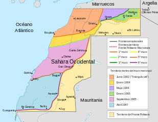
Deutsch: Karte des Marokkanischen Walls in der Westsahara. Er wurde in sechs Etappen in den 1980er Jahren errichtet, wie in der Karte dargestellt. Ebenfalls dargestellt ist das Polisario-Territorium und die Konfliktzone aus dem November 2020 (ermittelt anhand OSM). English: Map of the Moroccan Wall in Western Sahara - built over several stages, shows the six walls built, & when the territory was behind Moroccan wall. Also shows Polisario held territory who are based in Algeria (seen at top right). Euskara: Mendebaldeko Saharako harresien mapa العربية : خريطة الجدار الرملي المغربي في الصحراء الغربية |
||
| Ǹgụ́ụ̀bọ̀chị̀ | (UTC) | ||
| Mkpọlọ́gwụ̀ | |||
| Odé ákwụ́kwọ́ |
|
||
| Nke ya ozor |
[]
|


| This is a retouched picture, which means that it has been digitally altered from its original version. Modifications: spanish. The original can be viewed here: Western sahara walls moroccan map-en.svg:
|
Nkwényé
I, the copyright holder of this work, hereby publish it under the following license:
Edebere faịlụ a n'okpuru ikikeree Creative Commons Attribution-Share Alike 3.0 Unported license.
- I wepulara nóru:
- i nye – ikọpị,ikekasi na izịpụ ọru a
- i dowaria – igbanwee ọrụ a
- Ọ ga bụ na ọnọdụ ndi a:
- í-kpó-áhà – Ị ga-enyerịrị ugo kwesịrị ekwesị, nye njikọ na ikikere ahụ, ma gosikwa ma emere mgbanwe. Ị nwere ike ime ya n'ụzọ ezi uche ọ bụla, mana ọ bụghị n'ụzọ ọ bụla na-egosi na onye nyere ikikere kwadoro gị maọbụ ojiji gị.
- gbásàa kà – Ọ bụrụ na ị tụgharịgharịa, gbanwee, ma ọ bụ wulite n'elu ihe ahụ, ị ga-ekesa ndenye gị n'okpuru otu ma ọ bụ ikike dakọtara dị ka nke mbụ.
Original upload log
This image is a derivative work of the following images:
- File:Western_sahara_walls_moroccan_map-en.svg licensed with Cc-by-sa-3.0
- 2011-08-19T17:00:33Z M0tty 1676x1302 (197156 Bytes) corr color legend
- 2011-08-17T09:01:54Z M0tty 1676x1302 (197399 Bytes) corr legend
- 2011-08-16T18:46:57Z M0tty 1676x1302 (194768 Bytes) {{Information |Description={{en|Map of the [[w:Moroccan Wall]] in [[w:Western Sahara]] - built over several stages, shows the six walls built, & when the territory was behind Moroccan wall. Also shows polisaro held territory
Uploaded with derivativeFX
Ịta nke usòrò
Bìri èhì/ogè k'ị hụ òtù ụ̀fa dị̀ m̀gbè ahụ̀.
| Èhì/Ogè | Mbọ-aka | Ógólógó na asaá | Òjìème | Nkwute | |
|---|---|---|---|---|---|
| dị ùgbu â | 19:40, 29 Novemba 2011 | | 1,676 × 1,302 (193 KB) | Robot8A | == {{int:filedesc}} == {{Information |Description={{en|Map of the w:Moroccan Wall in w:Western Sahara - built over several stages, shows the six walls built, & when the territory was behind Moroccan wall. Also shows polisaro held territory who are |
Ojiji faịlụ
Ihe ndị na-eso 2 ihe eji Ihu akwụkwọ eme na faịlụ a:
Ejiji failụ zụrụ ọha
Wikis ndi a edeputara na eji kwa failụ a:
- Ihe eji na ar.wikipedia.org
- Ihe eji na arz.wikipedia.org
- Ihe eji na ast.wikipedia.org
- Ihe eji na ca.wikipedia.org
- Ihe eji na de.wikipedia.org
- Ihe eji na en.wikipedia.org
- Ihe eji na eo.wikipedia.org
- Ihe eji na es.wikipedia.org
- Sahara Occidental
- Muro marroquí
- Hasán II de Marruecos
- Estatus político del Sahara Occidental
- República Árabe Saharaui Democrática
- Invasión marroquí del Sahara español
- Historia de Marruecos
- Acuerdo Tripartito de Madrid
- Descolonización
- Historia del Sahara Occidental
- Guerguerat
- Hagunia
- Zug (Sahara Occidental)
- Bucraa
- Guerra del Sahara Occidental
- Zona Libre
- Ocupación marroquí del Sahara Occidental
- Frontera entre Argelia y Sahara Occidental
- Frontera entre Marruecos y Sahara Occidental
- Conflicto del Sahara Occidental
- Enfrentamientos del Sahara Occidental (2020-presente)
- Acuerdo de normalización de las relaciones entre Israel y Marruecos
- Ihe eji na eu.wikipedia.org
- Ihe eji na ha.wikipedia.org
- Ihe eji na ms.wikipedia.org
- Ihe eji na pt.wikipedia.org
- Ihe eji na sw.wikipedia.org
- Ihe eji na ts.wikipedia.org
Lee more global usage of this file.