
Usòrò:ProspectPark Brooklyn Nethermead.jpg
Failụ si na nke mbu (1,777 × 702 pixel, ívù akwukwo orunótu: 558 KB, MIME nke: image/jpeg)
Mmẹkụwátá
| Camera location | | View this and other nearby images on: OpenStreetMap |
|---|
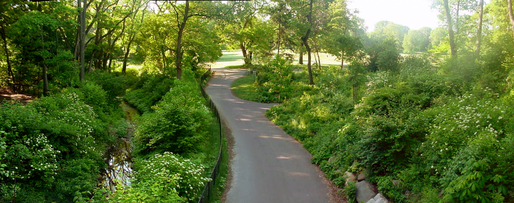
| Nkówá | Nethermead, Prospect Park, Brooklyn |
| Ǹgụ́ụ̀bọ̀chị̀ | |
| Mkpọlọ́gwụ̀ | Author's own work; a composite of digital images composing a panorama |
| Odé ákwụ́kwọ́ | Garry R. Osgood |
| Ọdà (Í jí kwá usòrò nke) |
Available under Creative Commons License and GFDL |
Looking south from the transverse roadway running over Nethermead Arches Bridge in Prospect Park, Brooklyn City of New York. June 05, 2005. about 7:00 AM EDT. The Nethermead is in the background center and toward the right. The footpath running from foreground to background runs under the western-most of the three arches that make up the bridge. The stream that runs through the Ravine flows under the middle arch; this stream is left of center in the photograph. A horse trail runs under the eastern-most arch and is barely visible off to the left. Nethermead Arches Bridge is situated approximately in the geographic center of the park and is an original structure of the park. (1869-1870). Following the path a ways further brings one to the Music Pagoda (1887), hidden in the middle ground trees off to the left. Even further, the footpath branches again; the right hand fork leads to the Lullwater Bridge and the left hand fork leads to the Binnen Bridge, overlooking the Binnen Falls. See the Prospect Park Alliance Map[dead link] for more information on park features.
This is a composite of four digital images, each produced by a Sony Mavica, FD-90.
Nkwényé

|
Í nwèrèíkí jé, gbạsáa na/ma í mezí akwukwo nka na okpúrù íwú GNU Ákwúkwó Íwú nke Owéré, Nké 1.2 ma nke íchè ndi Free Software Foundation; wéfùtàrà; na adighi nkejị di íchẹ, adighi édé nke Ihú-Ihü Ákwúkwó, na adighi Ázú-Ihü Ákwúkwó. Ákwúkwó iwu hé jéré jé di na nkeji kpóró GNU Ákwúkwó Íwú nke Owéré". |
| Edebere faịlụ a n'okpuru ikikeree Creative Commons Attribution-Share Alike 3.0 Unported license. | ||
| ||
| This licensing tag was added to this file as part of the GFDL licensing update. |
- I wepulara nóru:
- i nye – ikọpị,ikekasi na izịpụ ọru a
- i dowaria – igbanwee ọrụ a
- Ọ ga bụ na ọnọdụ ndi a:
- í-kpó-áhà – Ị ga-enyerịrị ugo kwesịrị ekwesị, nye njikọ na ikikere ahụ, ma gosikwa ma emere mgbanwe. Ị nwere ike ime ya n'ụzọ ezi uche ọ bụla, mana ọ bụghị n'ụzọ ọ bụla na-egosi na onye nyere ikikere kwadoro gị maọbụ ojiji gị.
Ịta nke usòrò
Bìri èhì/ogè k'ị hụ òtù ụ̀fa dị̀ m̀gbè ahụ̀.
| Èhì/Ogè | Mbọ-aka | Ógólógó na asaá | Òjìème | Nkwute | |
|---|---|---|---|---|---|
| dị ùgbu â | 10:59, 23 Julaị 2006 | 1,777 × 702 (558 KB) | Garry R. Osgood | {{ |Description=Nethermead, Prospect Park, Brooklyn |Source=Author's own work; a composite of digitial images composing a panorama |Date=June 05, 2005 |Author=Garry R. Osgood |Permission=Available under Creative Commons License and GFDL }} Looking south f |
Ojiji faịlụ
Ihe ndị na-eso ihe eji Ihu akwụkwọ eme na faịlụ a:
Ejiji failụ zụrụ ọha
Wikis ndi a edeputara na eji kwa failụ a:
- Ihe eji na de.wikipedia.org
- Ihe eji na en.wikipedia.org
- Ihe eji na en.wikiversity.org
- Ihe eji na en.wikivoyage.org
- Ihe eji na es.wikipedia.org
- Ihe eji na ga.wikipedia.org
- Ihe eji na pnb.wikipedia.org