Jump to content

Faịlụ:AmchitkaAlaskaLoc.png

Page contents not supported in other languages.
Shí Wikipedia, njikotá édémédé nke onyobulạ

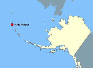
AmchitkaAlaskaLoc.png (300 × 219 pixel, ívù akwukwo orunótu: 14 KB, MIME nke: image/png)

Failụ a si na Wikimedia Commons,enwekwara ike iji ya eme ihe na arụmarụ ọzọ. Nkọwa na ihuakwukwọ nkọwa failụ eziri na okpuru.

Mmẹkụwátá

Nkówá

This map is a derivative work of a map layer from nationalatlas.gov, which states: "We have begun by collaboratively building "frameworks," the essential map layers that provide a foundation for all other maps. These basic layers, including small-scale harmonized information on North American roads, water, boundaries and the like, are being offered here for the first time. Like all other raw data and documentation offered here on nationalatlas.gov, these frameworks can be downloaded at no cost and used freely without copyright concerns or license restrictions."[1]

I donate the modifications and the resulting work to the public domain.
Mkpọlọ́gwụ̀ see above
Odé ákwụ́kwọ́ National Atlas - DW: Jakew

Nkwényé

Public domain
This map was obtained from an edition of the National Atlas of the United States. Like almost all works of the U.S. federal government, works from the National Atlas are in the public domain in the United States.
Online access: NationalAtlas.gov | 1970 print edition: Library of Congress, Perry-Castañeda Library

čeština | Deutsch | English | français | Bahasa Indonesia | italiano | македонски | മലയാളം | sicilianu | 中文 | 中文(简体)‎ | 中文(繁體)‎ | +/−

Original upload log

The original description page was here. All following user names refer to en.wikipedia.
  • 2006-10-08 16:15 Jakew 300×219×8 (14678 bytes) This map is a derivative work of a map layer from nationalatlas.gov, which states: "We have begun by collaboratively building "frameworks," the essential map layers that provide a foundation for all other maps. These basic layers, including small-scale ha

Nkowapụta

Tinye nkọwa otu ahịrị ihe faịlụ a na-anochi anya ya.

Ihe ndị egosiri na faịlụ a

depicts Bekee

image/png

checksum Bekee

29373e1014db60b020fe042aeb20de37cd506fdd

data size Bekee

14,678 byte

219 pixel

width Bekee

300 pixel

Ịta nke usòrò

Bìri èhì/ogè k'ị hụ òtù ụ̀fa dị̀ m̀gbè ahụ̀.

Èhì/OgèMbọ-akaÓgólógó na asaáÒjìèmeNkwute
dị ùgbu â21:20, 2 Ọgọọst 2007NvóÁká màkà otù ȯ dị nà 21:20, 2 Ọgọọst 2007300 × 219 (14 KB)Adam~commonswiki{{Information |Description=This map is a derivative work of a map layer from nationalatlas.gov, which states: "We have begun by collaboratively building "frameworks," the essential map layers that provide a foundation for all other maps. These basic layer

Ihe ndị na-eso ihe eji Ihu akwụkwọ eme na faịlụ a:

Ejiji failụ zụrụ ọha

Wikis ndi a edeputara na eji kwa failụ a: