
Usòrò:Hopetoun falls.jpg

Otu nyochaa a ha:800 × 533 piksels Ndị ọzọ mkpebi:320 × 213 piksels | 640 × 427 piksels | 1,024 × 683 piksels | 1,280 × 853 piksels | 2,560 × 1,707 piksels | 3,072 × 2,048 piksels.
Failụ si na nke mbu (3,072 × 2,048 pixel, ívù akwukwo orunótu: 2.82 MB, MIME nke: image/jpeg)
|

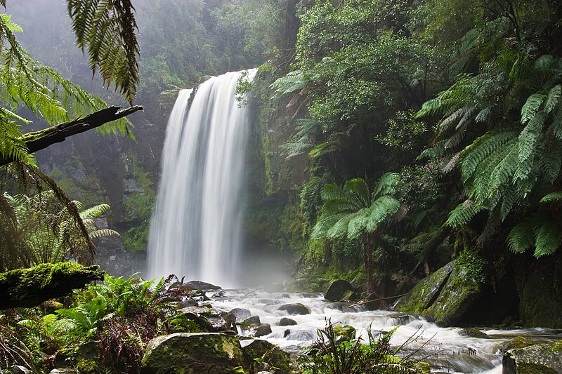
This image was selected as picture of the day on Wikimedia Commons for 17 March 2006. It was captioned as follows: English: The Hopetoun Falls is a waterfall in Victoria, Australia. Other languages:
Alemannisch: D Hepetoun-Wassrfäll in Victoria, Australie Čeština: Vodopády Hopetoun Falls ve Viktorii v Austrálii Deutsch: Die Hopetoun-Fälle in Victoria (Australien) English: The Hopetoun Falls is a waterfall in Victoria, Australia. Español: Catarata Hopetoun en Victoria (Australia) Français : Chutes d'eau d'Hopetoun (État de Victoria, Australie) Galego: Victoria, Australia Italiano: Le cascate Hopetoun, stato di Victoria, Australia Lëtzebuergesch: D'Hepetoun-Fäll, Victoria (Australien). Norsk nynorsk: Hopetounfalla i Victoria i Australia. Polski: Wodospad Hopetoun w Wiktorii (Australia) Português: A Queda de água de Hopetoun é uma cascata em Victoria, Austrália. Suomi: Hopetoun-putoukset Victoriassa, Australiassa. Български: Водопадът Хопетоун във Виктория, Австралия Русский: Водопад Хоупентон (Австралия, Виктория) العربية : ثي&é"-الا |
Mmẹkụwátá
| Nkówá |
English: Hopetoun Falls, Beech Forest, near Otway National Park, Victoria, Australia. Taken with a Canon 10D and 17-40 f/4L lens.
Français : Cascade de Hopetoun, Forêt de Beech, près du Parc National d'Otway, état de Victoria, Australie. Image prise avec un Canon 10D et un objectif 17-40 f/4L.
العربية: شلالاتُ هوبتون العملاقة في غابة الزان بالقربِ من حديقة أوتواي الوطنية في مدينة فيكتوريا، أستراليا. |
| Ǹgụ́ụ̀bọ̀chị̀ | |
| Mkpọlọ́gwụ̀ | Orü ọnwé |
| Odé ákwụ́kwọ́ | Diliff |
| Ọdà (Í jí kwá usòrò nke) |
Summary:In using this image or any subsequent derivatives of it, you are required to release the image under the same license. As such, any reproduction of this image, in any medium, must appear with a copy of, or full URL of the license.Attribution of this image to the author (DAVID ILIFF) is also required, preferably in a prominent location near the image.No other conditions may be added to, or removed from this license without the permission of the author and copyright holder.Suggested attribution: "Photo by DAVID ILIFF. License: CC BY-SA 3.0"Please review the full license requirements carefully before using this image. If you would like to clarify the terms of the license or negotiate less restrictive commercial licensing outside of the bounds of GFDL/CC-BY-SA, please contact me by email, or if you don't have a Wikipedia account you can either leave a message on my talk page with your contact details and your request, or you can contact me on Facebook. Please also send a 'friend request' to ensure that I am aware of your message. |
| Nke ya ozor |

| Camera location | | View this and other nearby images on: OpenStreetMap |
|---|
Nkwényé
I, the copyright holder of this work, hereby publish it under the following licenses:
Edebere faịlụ a n'okpuru ikikeree Creative Commons Attribution-Share Alike 3.0 Unported license.
Í-kpó-áhà: Photo by DAVID ILIFF
- I wepulara nóru:
- i nye – ikọpị,ikekasi na izịpụ ọru a
- i dowaria – igbanwee ọrụ a
- Ọ ga bụ na ọnọdụ ndi a:
- í-kpó-áhà – Ị ga-enyerịrị ugo kwesịrị ekwesị, nye njikọ na ikikere ahụ, ma gosikwa ma emere mgbanwe. Ị nwere ike ime ya n'ụzọ ezi uche ọ bụla, mana ọ bụghị n'ụzọ ọ bụla na-egosi na onye nyere ikikere kwadoro gị maọbụ ojiji gị.
- gbásàa kà – Ọ bụrụ na ị tụgharịgharịa, gbanwee, ma ọ bụ wulite n'elu ihe ahụ, ị ga-ekesa ndenye gị n'okpuru otu ma ọ bụ ikike dakọtara dị ka nke mbụ.

|
Í nwèrèíkí jé, gbạsáa na/ma í mezí akwukwo nka na okpúrù íwú GNU Ákwúkwó Íwú nke Owéré, Nké 1.2 ma nke íchè ndi Free Software Foundation; wéfùtàrà; na adighi nkejị di íchẹ, adighi édé nke Ihú-Ihü Ákwúkwó, na adighi Ázú-Ihü Ákwúkwó. Ákwúkwó iwu hé jéré jé di na nkeji kpóró GNU Ákwúkwó Íwú nke Owéré". |
Ị nwere ike họrọ ikikere nke masịrị gị.
Ịta nke usòrò
Bìri èhì/ogè k'ị hụ òtù ụ̀fa dị̀ m̀gbè ahụ̀.
| Èhì/Ogè | Mbọ-aka | Ógólógó na asaá | Òjìème | Nkwute | |
|---|---|---|---|---|---|
| dị ùgbu â | 19:06, 13 Ọktoba 2009 | | 3,072 × 2,048 (2.82 MB) | Diliff | Reupload original file at 3072x2048 res |
| 02:27, 30 Ọktoba 2005 |  | 1,400 × 933 (667 KB) | Diliff | Hopetoun Falls, Beech Forest, near Otway National Park, Victoria. Taken on the 27th of July, 2005 with a Canon 10D and 17-40 f/4L lens. |
Ojiji faịlụ
Ihe ndị na-eso ihe eji Ihu akwụkwọ eme na faịlụ a:
Ejiji failụ zụrụ ọha
Wikis ndi a edeputara na eji kwa failụ a:
- Ihe eji na af.wikipedia.org
- Ihe eji na ang.wikipedia.org
- Ihe eji na an.wikipedia.org
- Ihe eji na ar.wikipedia.org
- Ihe eji na azb.wikipedia.org
- Ihe eji na az.wikipedia.org
- Ihe eji na ba.wikipedia.org
- Ihe eji na bcl.wikipedia.org
- Ihe eji na be-tarask.wikipedia.org
- Ihe eji na beta.wikiversity.org
- Ihe eji na be.wikipedia.org
- Ihe eji na bg.wikipedia.org
- Ihe eji na bh.wikipedia.org
- Ihe eji na bn.wikipedia.org
- Ihe eji na bo.wikipedia.org
- Ihe eji na br.wikipedia.org
- Ihe eji na bs.wikipedia.org
- Ihe eji na ca.wikipedia.org
- Ihe eji na ceb.wikipedia.org
- Ihe eji na ce.wikipedia.org
- Ihe eji na ckb.wikipedia.org
- Ihe eji na ckb.wiktionary.org
- Ihe eji na cs.wikipedia.org
- Ihe eji na cv.wikipedia.org
- Ihe eji na cy.wikipedia.org
Lee more global usage of this file.