
Usòrò:Kaffirland map.png

Otu nyochaa a ha:354 × 600 piksels Ndị ọzọ mkpebi:141 × 240 piksels | 283 × 480 piksels | 453 × 768 piksels | 1,120 × 1,898 piksels.
Failụ si na nke mbu (1,120 × 1,898 pixel, ívù akwukwo orunótu: 241 KB, MIME nke: image/png)
Mmẹkụwátá
| Nkówá |
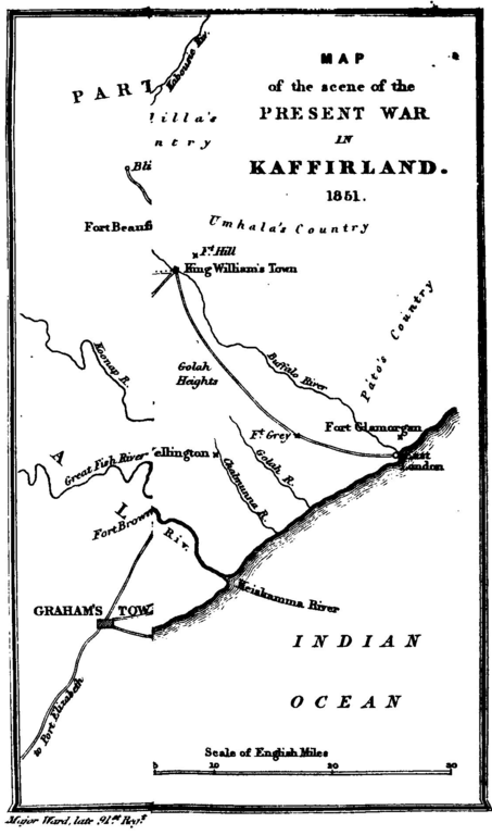
English: A sketch map of the Xhosa region beside British South Africa, called Kaffraria/Kaffirland in the 1840s |
| Ǹgụ́ụ̀bọ̀chị̀ | |
| Mkpọlọ́gwụ̀ |
Five years in Kaffirland : with sketches of the late war in that country to the conclusion of peace : written on the spot. (Third edition, London 1851) |
| Odé ákwụ́kwọ́ | Harriet Ward (d.1873). Map by her husband (b.1798) |
Nkwényé
|
Orüá di na áma ime obodo nwéré iwu nke si ndu onye kéré iheá gi di na afor 70 garaga ma afor nke di nso. This work is in the public domain in the United States because it was published (or registered with the U.S. Copyright Office) before January 1, 1929. | |
| This file has been identified as being free of known restrictions under copyright law, including all related and neighboring rights. | |
Ịta nke usòrò
Bìri èhì/ogè k'ị hụ òtù ụ̀fa dị̀ m̀gbè ahụ̀.
| Èhì/Ogè | Mbọ-aka | Ógólógó na asaá | Òjìème | Nkwute | |
|---|---|---|---|---|---|
| dị ùgbu â | 15:15, 21 Novemba 2016 | | 1,120 × 1,898 (241 KB) | Lelijg | User created page with UploadWizard |
Ojiji faịlụ
Ihe ndị na-eso ihe eji Ihu akwụkwọ eme na faịlụ a:
Ejiji failụ zụrụ ọha
Wikis ndi a edeputara na eji kwa failụ a:
- Ihe eji na en.wikipedia.org