
Usòrò:LakeKivu satellite.jpg
Nke káchá mmá na ányá àdíghị.
LakeKivu_satellite.jpg (296 × 464 pixel, ívù akwukwo orunótu: 21 KB, MIME nke: image/jpeg)
Mmẹkụwátá
| Nkówá |
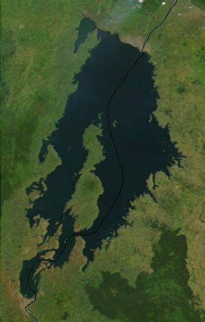
English: Lake Kivu, Africa, as seen from space. The black line marks the border between Rwanda and the Democratic Republic of the Congo. Cropped from a larger image (EAfrica.A2003033.0820.250m.jpg). |
| Ǹgụ́ụ̀bọ̀chị̀ | |
| Mkpọlọ́gwụ̀ | "Fires in East Africa" - Visible Earth Image ID 4957 (details, image at 250m resolution) |
| Odé ákwụ́kwọ́ | NASA |
Nkwényé
| This file is in the public domain in the United States because it was solely created by NASA. NASA copyright policy states that "NASA material is not protected by copyright unless noted". (See Template:PD-USGov, NASA copyright policy page or JPL Image Use Policy.) | ||
 |
Warnings:
|
Original upload log
from en.wikipedia.org
- Uploaded on 23 February 2006 by en:User:Paphrag.
Ịta nke usòrò
Bìri èhì/ogè k'ị hụ òtù ụ̀fa dị̀ m̀gbè ahụ̀.
| Èhì/Ogè | Mbọ-aka | Ógólógó na asaá | Òjìème | Nkwute | |
|---|---|---|---|---|---|
| dị ùgbu â | 14:19, 19 Septemba 2010 | | 296 × 464 (21 KB) | LobStoR | lossless crop from source NASA image at 250m resolution |
| 22:43, 24 Mee 2006 |  | 295 × 476 (108 KB) | Dubhe | from en.wiki |
Ojiji faịlụ
Ihe ndị na-eso ihe eji Ihu akwụkwọ eme na faịlụ a:
Ejiji failụ zụrụ ọha
Wikis ndi a edeputara na eji kwa failụ a:
- Ihe eji na af.wikipedia.org
- Ihe eji na ar.wikipedia.org
- Ihe eji na arz.wikipedia.org
- Ihe eji na ast.wikipedia.org
- Ihe eji na bn.wikipedia.org
- Ihe eji na br.wikipedia.org
- Ihe eji na ca.wikipedia.org
- Ihe eji na ceb.wikipedia.org
- Ihe eji na cs.wikipedia.org
- Ihe eji na da.wikipedia.org
- Ihe eji na de.wikipedia.org
- Ihe eji na de.wikivoyage.org
- Ihe eji na dsb.wikipedia.org
- Ihe eji na el.wikipedia.org
- Ihe eji na en.wikipedia.org
- Ihe eji na eo.wikipedia.org
- Ihe eji na es.wikipedia.org
- Ihe eji na et.wikipedia.org
- Ihe eji na eu.wikipedia.org
- Ihe eji na fa.wikipedia.org
- Ihe eji na fi.wikipedia.org
- Ihe eji na fr.wikipedia.org
- Ihe eji na fr.wikivoyage.org
- Ihe eji na gl.wikipedia.org
- Ihe eji na he.wikipedia.org
- Ihe eji na hsb.wikipedia.org
- Ihe eji na hy.wikipedia.org
- Ihe eji na it.wikipedia.org
- Ihe eji na ja.wikipedia.org
- Ihe eji na ka.wikipedia.org
- Ihe eji na ko.wikipedia.org
Lee more global usage of this file.