
Usòrò:MonthlyMeanT.gif
Nke káchá mmá na ányá àdíghị.
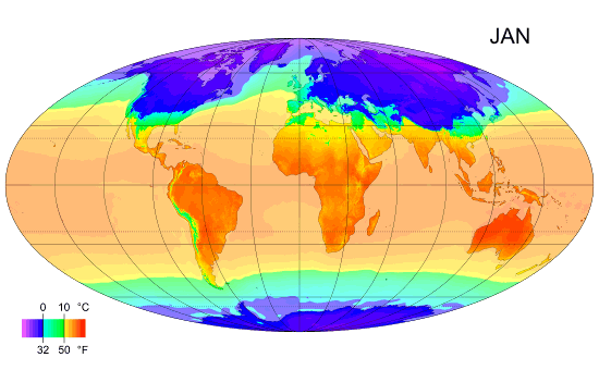
MonthlyMeanT.gif (550 × 340 pixel, ívù akwukwo orunótu: 405 KB, MIME nke: image/gif, etemte, 12 frames, 11 s)
Mmẹkụwátá
| Nkówá |
English: Animated global map of monthly long term mean surface air temperature (Mollweide projection). |
| Ǹgụ́ụ̀bọ̀chị̀ | |
| Mkpọlọ́gwụ̀ | Own work by uploader, sources: CRU CL 2.0 (New, M., Lister, D., Hulme, M. and Makin, I., 2002: A high-resolution data set of surface climate over global land areas. Climate Research 21: 1–25), NCEP/NCAR Reanalysis Derived data v. 1 provided by the NOAA/OAR/ESRL PSD, Boulder, CO (Kalnay et al., 1996: The NCEP/NCAR 40-Year Reanalysis Project. Bulletin of the American Meteorological Society 77 (3): 437–471.), World Coast Line. |
| Odé ákwụ́kwọ́ | PZmaps |
| Nke ya ozor | Derivative works of this file: MonthlyMeanT DEC.jpg |
Nkwényé
I, the copyright holder of this work, hereby publish it under the following licenses:
Edebere faịlụ a n'okpuru ikikeree Creative Commons Attribution-Share Alike 3.0 Unported license.
- I wepulara nóru:
- i nye – ikọpị,ikekasi na izịpụ ọru a
- i dowaria – igbanwee ọrụ a
- Ọ ga bụ na ọnọdụ ndi a:
- í-kpó-áhà – Ị ga-enyerịrị ugo kwesịrị ekwesị, nye njikọ na ikikere ahụ, ma gosikwa ma emere mgbanwe. Ị nwere ike ime ya n'ụzọ ezi uche ọ bụla, mana ọ bụghị n'ụzọ ọ bụla na-egosi na onye nyere ikikere kwadoro gị maọbụ ojiji gị.
- gbásàa kà – Ọ bụrụ na ị tụgharịgharịa, gbanwee, ma ọ bụ wulite n'elu ihe ahụ, ị ga-ekesa ndenye gị n'okpuru otu ma ọ bụ ikike dakọtara dị ka nke mbụ.

|
Í nwèrèíkí jé, gbạsáa na/ma í mezí akwukwo nka na okpúrù íwú GNU Ákwúkwó Íwú nke Owéré, Nké 1.2 ma nke íchè ndi Free Software Foundation; wéfùtàrà; na adighi nkejị di íchẹ, adighi édé nke Ihú-Ihü Ákwúkwó, na adighi Ázú-Ihü Ákwúkwó. Ákwúkwó iwu hé jéré jé di na nkeji kpóró GNU Ákwúkwó Íwú nke Owéré". |
Ị nwere ike họrọ ikikere nke masịrị gị.
Ịta nke usòrò
Bìri èhì/ogè k'ị hụ òtù ụ̀fa dị̀ m̀gbè ahụ̀.
| Èhì/Ogè | Mbọ-aka | Ógólógó na asaá | Òjìème | Nkwute | |
|---|---|---|---|---|---|
| dị ùgbu â | 12:38, 25 Febụwarị 2009 | | 550 × 340 (405 KB) | PZmaps | {{Information |Description={{en|1=Global animated map of monthly long term mean surface air temperature (Mollweide projection).}} |Source=Own work by uploader, sources: [http://www.cru.uea.ac.uk/cru/data/hrg.htm CRU CL 2.0] (New, M., Lister, D., Hulme, M. |
Ojiji faịlụ
Ihe ndị na-eso ihe eji Ihu akwụkwọ eme na faịlụ a:
Ejiji failụ zụrụ ọha
Wikis ndi a edeputara na eji kwa failụ a:
- Ihe eji na am.wikipedia.org
- Ihe eji na ar.wikipedia.org
- Ihe eji na ast.wikipedia.org
- Ihe eji na azb.wikipedia.org
- Ihe eji na az.wikipedia.org
- Ihe eji na ba.wikipedia.org
- Ihe eji na bg.wikipedia.org
- Ihe eji na bo.wikipedia.org
- Ihe eji na ca.wikipedia.org
- Ihe eji na ceb.wikipedia.org
- Ihe eji na ce.wikipedia.org
- Ihe eji na ckb.wikipedia.org
- Ihe eji na cy.wikipedia.org
- Ihe eji na de.wikipedia.org
- Ihe eji na en.wikipedia.org
- Ihe eji na en.wikibooks.org
- Ihe eji na en.wikiversity.org
- Ihe eji na es.wikipedia.org
- Ihe eji na es.wikinews.org
- Ihe eji na fi.wikipedia.org
- Ihe eji na hu.wikipedia.org
- Ihe eji na hy.wikipedia.org
Lee more global usage of this file.