
Usòrò:Mount Rainier 5917s.JPG

Otu nyochaa a ha:709 × 600 piksels Ndị ọzọ mkpebi:284 × 240 piksels | 567 × 480 piksels | 908 × 768 piksels | 1,210 × 1,024 piksels | 2,420 × 2,048 piksels | 4,920 × 4,163 piksels.
Failụ si na nke mbu (4,920 × 4,163 pixel, ívù akwukwo orunótu: 4.95 MB, MIME nke: image/jpeg)
| Nkówá |
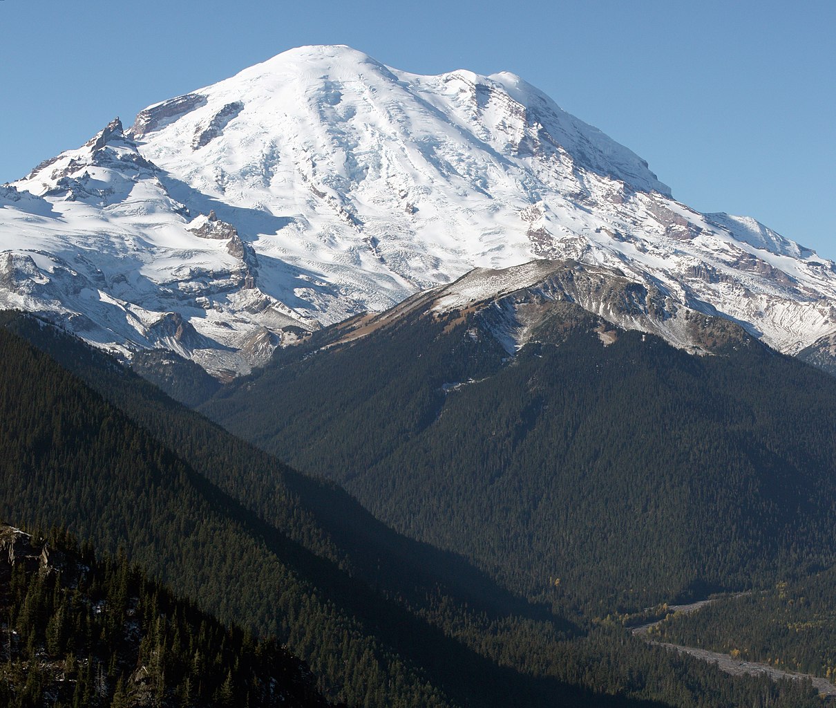
English: Mount Rainier with its main summit, Columbia Crest (14410 feet) at the center. Emmons Glacier covers most of the visible flank of the mountain. Ingraham Glacier (left) is between Gibraltar Rock (12660 feet) high on the left skyline and Disappointment Cleaver. Left of Gibraltar Rock is sharp pointed Little Tahoma (11138 feet) with Frying Pan Glacier on its flank. It is the source of Frying Pan Creek in the valley left of forested and rounded Goat Island Mountain, in front of the Emmons Glacier. Liberty Cap (14112 feet) is visible on the right center skyline behind Russell Cliff. Curtis Ridge descends to the right from Russell Cliff. Winthrop Glacier flows right below Curtis Ridge and behind shallow Steamboat Prow (9680 feet) with the small Inter Glacier on its northeast face. The White River comes from the Emmons Glacier and flows around the right side of Goat Island Mountain in the watercourse visible below right.
Esperanto: monto Rainier vidata de oriento |
| Ǹgụ́ụ̀bọ̀chị̀ | 22 Ọktoba 2008, 11:19:11 −07:00 |
| Mkpọlọ́gwụ̀ | Orü ọnwé |
| Odé ákwụ́kwọ́ | Walter Siegmund (talk) |
| Nke ya ozor |
|


| Camera location | | View this and other nearby images on: OpenStreetMap |
|---|
- Location source: Garmin GPSmap 60CSx
- Location Datum: WGS84
- Viewpoint location: Crystal Lakes Trail, Mount Rainier National Park
- Viewpoint elevation: 1732 meter (5684 ft)
- View direction: West-southwest
- Camera: Canon EOS DIGITAL REBEL XSi
- Exposure Time: 1/800
- F Number: f/11.0
- Focal Length: 70.0
- ISO Speed Rating: 400
This image was created with Hugin.
| This is a retouched picture, which means that it has been digitally altered from its original version. Modifications: Stitched two images; adjusted levels and color balance; please see other versions in the information template for the originals. Modifications made by Wsiegmund.
|
©2009 Walter Siegmund
Nkwényé
I, the copyright holder of this work, hereby publish it under the following licenses:

|
Í nwèrèíkí jé, gbạsáa na/ma í mezí akwukwo nka na okpúrù íwú GNU Ákwúkwó Íwú nke Owéré, Nké 1.2 ma nke íchè ndi Free Software Foundation; wéfùtàrà; na adighi nkejị di íchẹ, adighi édé nke Ihú-Ihü Ákwúkwó, na adighi Ázú-Ihü Ákwúkwó. Ákwúkwó iwu hé jéré jé di na nkeji kpóró GNU Ákwúkwó Íwú nke Owéré". |
This file is licensed under the Creative Commons Attribution-Share Alike 3.0 Unported, 2.5 Generic, 2.0 Generic and 1.0 Generic license.
- I wepulara nóru:
- i nye – ikọpị,ikekasi na izịpụ ọru a
- i dowaria – igbanwee ọrụ a
- Ọ ga bụ na ọnọdụ ndi a:
- í-kpó-áhà – Ị ga-enyerịrị ugo kwesịrị ekwesị, nye njikọ na ikikere ahụ, ma gosikwa ma emere mgbanwe. Ị nwere ike ime ya n'ụzọ ezi uche ọ bụla, mana ọ bụghị n'ụzọ ọ bụla na-egosi na onye nyere ikikere kwadoro gị maọbụ ojiji gị.
- gbásàa kà – Ọ bụrụ na ị tụgharịgharịa, gbanwee, ma ọ bụ wulite n'elu ihe ahụ, ị ga-ekesa ndenye gị n'okpuru otu ma ọ bụ ikike dakọtara dị ka nke mbụ.
Ị nwere ike họrọ ikikere nke masịrị gị.
Ịta nke usòrò
Bìri èhì/ogè k'ị hụ òtù ụ̀fa dị̀ m̀gbè ahụ̀.
| Èhì/Ogè | Mbọ-aka | Ógólógó na asaá | Òjìème | Nkwute | |
|---|---|---|---|---|---|
| dị ùgbu â | 05:27, 21 Maachị 2009 | | 4,920 × 4,163 (4.95 MB) | Wsiegmund | Removed dust spots |
| 04:22, 13 Maachị 2009 |  | 4,920 × 4,163 (4.95 MB) | Wsiegmund | {{Information |Description = {{en|Mount Rainier with its main summit, Columbia Crest (14410 feet) at the center. Emmons Glacier covers most of the visible flank of the mountain. Ingraham Glacier (left) is between Gibraltar Rock (12660 feet) high on th |
Ojiji faịlụ
Ihe ndị na-eso ihe eji Ihu akwụkwọ eme na faịlụ a:
Ejiji failụ zụrụ ọha
Wikis ndi a edeputara na eji kwa failụ a:
- Ihe eji na ar.wikipedia.org
- Ihe eji na arz.wikipedia.org
- Ihe eji na bn.wikipedia.org
- Ihe eji na ca.wikipedia.org
- Ihe eji na ceb.wikipedia.org
- Ihe eji na cs.wikipedia.org
- Ihe eji na de.wikipedia.org
- Ihe eji na el.wikipedia.org
- Ihe eji na en.wikipedia.org
- Pacific Northwest
- Dixy Lee Ray
- List of mountain peaks of North America
- List of National Historic Landmarks in Washington (state)
- List of the most isolated major summits of the United States
- Talk:Mount Rainier/Archive 1
- User talk:Hike395/Archive 10
- List of ultras of North America
- List of the most prominent summits of the United States
- List of the major 100-kilometer summits of North America
- Wikipedia:Teahouse/Guest book/Archive 1
- User:Ecpiandy/Washington (state)
- List of the highest major summits of North America
- List of the highest major summits of the United States
- Ihe eji na en.wikiversity.org
- Ihe eji na en.wikivoyage.org
- Ihe eji na eo.wikipedia.org
- Ihe eji na es.wikipedia.org
- Ihe eji na es.wikivoyage.org
- Ihe eji na et.wikipedia.org
- Ihe eji na eu.wikipedia.org
- Ihe eji na frr.wikipedia.org
- Ihe eji na fr.wikipedia.org
- Mont Saint Helens
- Mont Rainier
- Mont Shasta
- Chaîne des Cascades
- Mont Hood
- Mont Adams
- Mont Baker
- Pic Glacier
- Three Sisters (Oregon)
- Pic Lassen
- Medicine Lake (volcan)
- Portail:États-Unis/Articles de qualité
- Mont Washington (Oregon)
- Wikipédia:Lumière sur/Mai 2008
- Wikipédia:Lumière sur/Mont Rainier
- Wikipédia:Sélection/Géographie
- Wikipédia:Sélection/Volcanisme
- Mont Thielsen
Lee more global usage of this file.