
Usòrò:Regions of the United States EPA.svg

Size of this PNG preview of this SVG file: 800 × 495 piksels. Ndị ọzọ mkpebi:320 × 198 piksels | 640 × 396 piksels | 1,024 × 633 piksels | 1,280 × 791 piksels | 2,560 × 1,583 piksels | 959 × 593 piksels.
Failụ si na nke mbu (usòrò SVG, nà áhà pixel 959 × 593, ívụ usòrò: 119 KB)
| Nkówá |
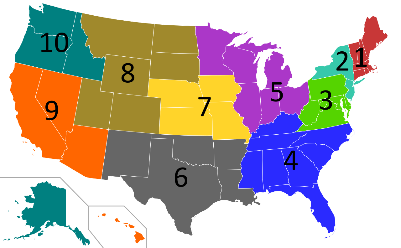
A map of the United States showing the 10 regions of the Environmental Protection Agency.
|
|
| Ǹgụ́ụ̀bọ̀chị̀ | (UTC) | |
| Mkpọlọ́gwụ̀ | ||
| Odé ákwụ́kwọ́ |
|
I, the copyright holder of this work, hereby publish it under the following licenses:
| Edebere faịlụ a n'okpuru ikikeree Creative Commons Attribution-Share Alike 3.0 Unported license. | ||
| ||
| This licensing tag was added to this file as part of the GFDL licensing update. |

|
Í nwèrèíkí jé, gbạsáa na/ma í mezí akwukwo nka na okpúrù íwú GNU Ákwúkwó Íwú nke Owéré, Nké 1.2 ma nke íchè ndi Free Software Foundation; wéfùtàrà; na adighi nkejị di íchẹ, adighi édé nke Ihú-Ihü Ákwúkwó, na adighi Ázú-Ihü Ákwúkwó. Ákwúkwó iwu hé jéré jé di na nkeji kpóró GNU Ákwúkwó Íwú nke Owéré". |
Ị nwere ike họrọ ikikere nke masịrị gị.
Original upload log
This image is a derivative work of the following images:
- File:Blank_US_Map.svg licensed with Cc-by-sa-3.0-migrated, GFDL
- 2009-11-05T19:44:02Z NuclearVacuum 959x593 (91518 Bytes) minor fix from previous upload
- 2009-11-05T19:39:42Z NuclearVacuum 959x593 (88399 Bytes) Fixed up the borders so they are connected with each state and loosing that gap between them.
- 2008-10-09T16:36:40Z Howcheng 959x593 (80121 Bytes) Reverted to version as of 08:32, 14 June 2007
- 2008-03-12T00:20:02Z AMK1211 959x593 (174744 Bytes) Added borders: Light blue for water borders and black for land borders (international borders thicker).
- 2007-06-14T08:32:47Z Fibonacci 959x593 (80121 Bytes) Optimised code.
- 2006-07-12T23:00:30Z Theshibboleth 959x593 (90537 Bytes) The line framework around Alaska and Hawaii has been pushed a bit
- 2006-07-12T06:35:19Z Theshibboleth 959x593 (89828 Bytes) added DC
- 2006-07-12T06:05:05Z Theshibboleth 959x593 (89649 Bytes) {{Information |Description=A blank map of the United States in scalable vector form. |Source=Own work, based on [[:Image:Electorial map.svg]], inspired by [[:Image:BlankMap-World.png]] |Date=11 July 2006 |Author=[[User:Theshi
Uploaded with derivativeFX
Ịta nke usòrò
Bìri èhì/ogè k'ị hụ òtù ụ̀fa dị̀ m̀gbè ahụ̀.
| Èhì/Ogè | Mbọ-aka | Ógólógó na asaá | Òjìème | Nkwute | |
|---|---|---|---|---|---|
| dị ùgbu â | 19:54, 4 Ọktoba 2010 | | 959 × 593 (119 KB) | Ninjatacoshell | {{Information |Description=A map of the United States showing the 10 regions of the Environmental Protection Agency.<br><br> Key: <br> <table border="0" cellspacing="0" cellpadding="1" style="background:transparent"> <tr valign="top"><td> {{Legend|#C8373 |
Ojiji faịlụ
Ihe ndị na-eso ihe eji Ihu akwụkwọ eme na faịlụ a:
Ejiji failụ zụrụ ọha
Wikis ndi a edeputara na eji kwa failụ a:
- Ihe eji na en.wikipedia.org
- Ihe eji na he.wikipedia.org
- Ihe eji na simple.wikipedia.org
- Ihe eji na zh.wikipedia.org