
Usòrò:Txu-oclc-6595921-nc30-15 crop southwest.jpg

Otu nyochaa a ha:800 × 427 piksels Ndị ọzọ mkpebi:320 × 171 piksels | 640 × 341 piksels | 1,341 × 715 piksels.
Failụ si na nke mbu (1,341 × 715 pixel, ívù akwukwo orunótu: 1.36 MB, MIME nke: image/jpeg)
| Nkówá |
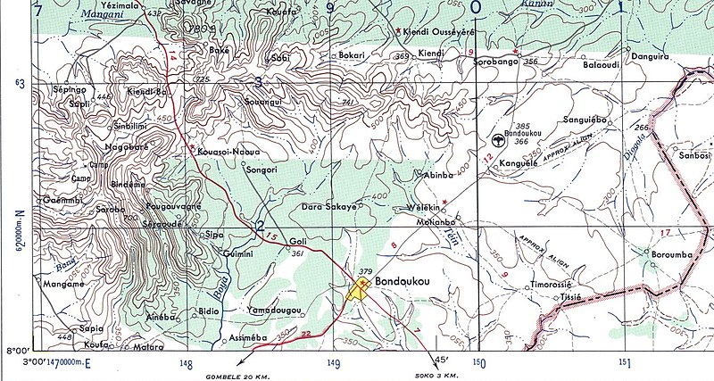
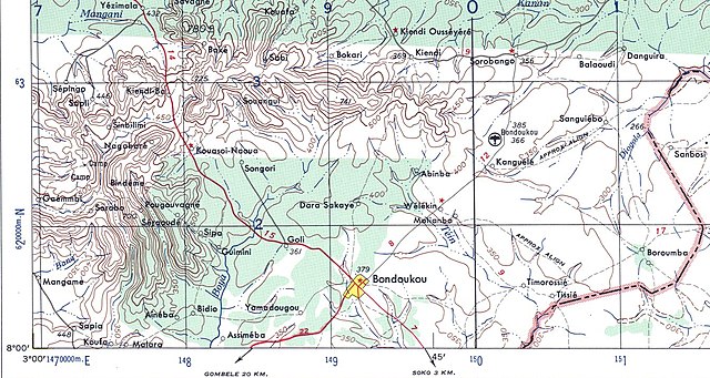
English: US Army map of West Africa, specifically the area along northern border of modern Ghana and Cote d'Ivoire (then Gold Coast Colony and French West Africa). |
| Ǹgụ́ụ̀bọ̀chị̀ | |
| Mkpọlọ́gwụ̀ | |
| Odé ákwụ́kwọ́ |
|
| This is a retouched picture, which means that it has been digitally altered from its original version. Modifications: crop. The original can be viewed here: Txu-oclc-6595921-nc30-15.jpg:
|
This file is a work of a U.S. Army soldier or employee, taken or made as part of that person's official duties. As a work of the U.S. federal government, it is in the public domain in the United States.
|
 |
Original upload log
This image is a derivative work of the following images:
- Image:Txu-oclc-6595921-nc30-15.jpg licensed with PD-USGov-Military-Army
- 2008-09-13T01:15:15Z T L Miles 5000x3785 (5264461 Bytes) {{Information |Description={{en|1=US Army map of West Africa, specifically the area along northern border of modern Ghana and Cote d'Ivoire (then Gold Coast Colony and French West Africa).}} |Source=http://www.lib.utexas.edu/
Uploaded with derivativeFX
Ịta nke usòrò
Bìri èhì/ogè k'ị hụ òtù ụ̀fa dị̀ m̀gbè ahụ̀.
| Èhì/Ogè | Mbọ-aka | Ógólógó na asaá | Òjìème | Nkwute | |
|---|---|---|---|---|---|
| dị ùgbu â | 01:22, 13 Septemba 2008 | | 1,341 × 715 (1.36 MB) | T L Miles | {{Information |Description={{en|1=US Army map of West Africa, specifically the area along northern border of modern Ghana and Cote d'Ivoire (then Gold Coast Colony and French West Africa).}} |Source=*Image:Txu-oclc-6595921-nc30-15.jpg |Date=2008-09- |
Ojiji faịlụ
Ihe ndị na-eso ihe eji Ihu akwụkwọ eme na faịlụ a:
Ejiji failụ zụrụ ọha
Wikis ndi a edeputara na eji kwa failụ a: