
Usòrò:Un-chad.png

Failụ si na nke mbu (1,617 × 2,078 pixel, ívù akwukwo orunótu: 1.43 MB, MIME nke: image/png)
Mmẹkụwátá
| Nkówá |
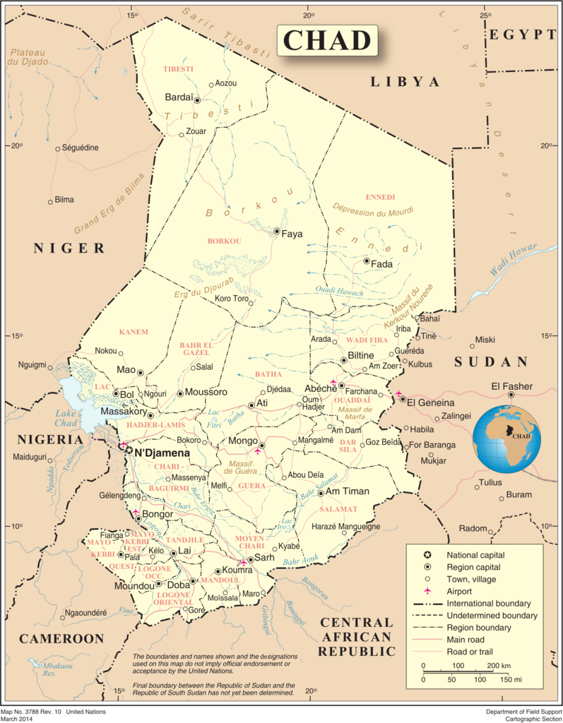
English: Map of Chad, showing region names and borders as of 2007. Based on UN map number 3788 (modified to remove UN name and reference number). |
| Ǹgụ́ụ̀bọ̀chị̀ | |
| Mkpọlọ́gwụ̀ |
|
| Odé ákwụ́kwọ́ | United Nations, Cartographic Section |
| Ọdà (Í jí kwá usòrò nke) |
Public domain |
Nkwényé
| This image is a map derived from a United Nations map.
Unless stated otherwise, UN maps are to be considered in the public domain. This applies worldwide. UN maps are, in principle, open source material and you can use them in your work or for making your own map. UN requests however that you delete the UN name, logo and reference number upon any modification to the map. Content of your map will be your responsibility. You can state in your publication, if you wish, something like: based on UN map … (map name, map number, revision number and date). See: Geospatial Information Section. And: Geospatial, location data for a better world. |
 |
Ịta nke usòrò
Bìri èhì/ogè k'ị hụ òtù ụ̀fa dị̀ m̀gbè ahụ̀.
| Èhì/Ogè | Mbọ-aka | Ógólógó na asaá | Òjìème | Nkwute | |
|---|---|---|---|---|---|
| dị ùgbu â | 16:37, 14 Jenụwarị 2016 | | 1,617 × 2,078 (1.43 MB) | Bstouttt | March 2014. United Nations. Chad http://www.un.org/Depts/Cartographic/map/profile/chad.pdf |
| 00:49, 24 Ọktoba 2007 |  | 2,348 × 2,947 (1.38 MB) | Jeroen | {{UN map}} Category:Maps of Chad |
Ojiji faịlụ
Ihe ndị na-eso ihe eji Ihu akwụkwọ eme na faịlụ a:
Ejiji failụ zụrụ ọha
Wikis ndi a edeputara na eji kwa failụ a:
- Ihe eji na avk.wikipedia.org
- Ihe eji na en.wikipedia.org
- Ihe eji na fa.wikipedia.org
- Ihe eji na fr.wikipedia.org
- Ihe eji na hu.wikipedia.org
- Ihe eji na ka.wikipedia.org
- Ihe eji na mk.wikipedia.org
- Ihe eji na ms.wikipedia.org
- Ihe eji na nl.wikipedia.org
- Ihe eji na pl.wiktionary.org
- Ihe eji na stq.wikipedia.org
- Ihe eji na tl.wikipedia.org
- Ihe eji na tr.wikipedia.org
- Ihe eji na uk.wikipedia.org
- Ihe eji na ur.wikipedia.org
- Ihe eji na www.wikidata.org
- Ihe eji na zh.wikipedia.org