
Usòrò:Sahel Map-Africa rough.png
Otu nyochaa a ha:800 × 370 piksels Ndị ọzọ mkpebi:320 × 148 piksels | 640 × 296 piksels | 1,024 × 474 piksels | 2,000 × 925 piksels.
Failụ si na nke mbu (2,000 × 925 pixel, ívù akwukwo orunótu: 291 KB, MIME nke: image/png)
| Nkówá |
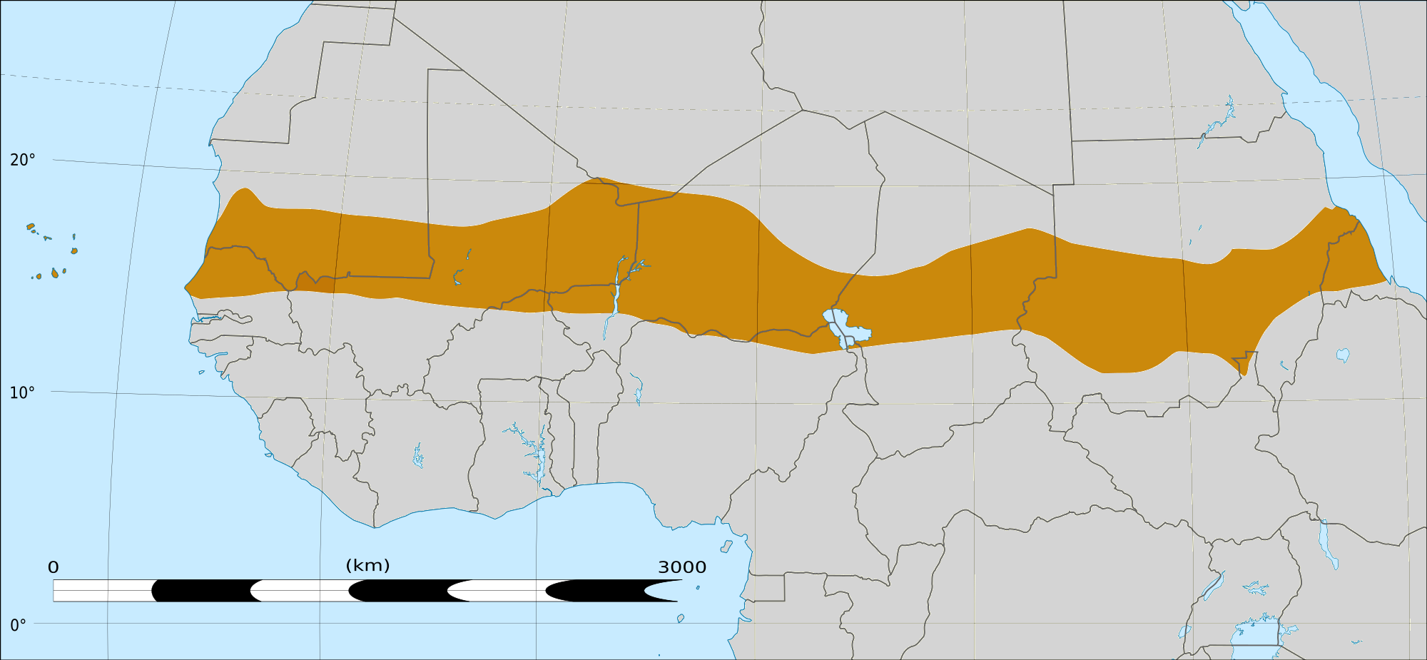
English: Map of Africa, with the Sahel highlighted in orange.
This is roughly the African land area between the lines of 200mm (north) and 600mm (south) mean 20th century annual rainfall. This is limited to land areas directly to the south of the Sahara desert and including the islands of Cape Verde, but not including other areas in Africa with the same rainfall statistics. This is one, but not the only, definition of the Sahel region. |
|||
| Ǹgụ́ụ̀bọ̀chị̀ | 20 Febụwarị 2009 03:54 (UTC) | |||
| Mkpọlọ́gwụ̀ |
Felix Koenig: "created/photographed by myself (based on the existing blank map of Africa)"
|
|||
| Odé ákwụ́kwọ́ | ||||
| Nke ya ozor |
|


| This is a retouched picture, which means that it has been digitally altered from its original version. Modifications: Reproduced Sahel boundary from Map sahel.jpg on png map, cropped. The original can be viewed here: BlankMap-Africa2.png:
|
Nkwényé
I, the copyright holder of this work, hereby publish it under the following licenses:

|
Í nwèrèíkí jé, gbạsáa na/ma í mezí akwukwo nka na okpúrù íwú GNU Ákwúkwó Íwú nke Owéré, Nké 1.2 ma nke íchè ndi Free Software Foundation; wéfùtàrà; na adighi nkejị di íchẹ, adighi édé nke Ihú-Ihü Ákwúkwó, na adighi Ázú-Ihü Ákwúkwó. Ákwúkwó iwu hé jéré jé di na nkeji kpóró GNU Ákwúkwó Íwú nke Owéré". |
This file is licensed under the Creative Commons Attribution-Share Alike 4.0 International, 3.0 Unported, 2.5 Generic, 2.0 Generic and 1.0 Generic license.
- I wepulara nóru:
- i nye – ikọpị,ikekasi na izịpụ ọru a
- i dowaria – igbanwee ọrụ a
- Ọ ga bụ na ọnọdụ ndi a:
- í-kpó-áhà – Ị ga-enyerịrị ugo kwesịrị ekwesị, nye njikọ na ikikere ahụ, ma gosikwa ma emere mgbanwe. Ị nwere ike ime ya n'ụzọ ezi uche ọ bụla, mana ọ bụghị n'ụzọ ọ bụla na-egosi na onye nyere ikikere kwadoro gị maọbụ ojiji gị.
- gbásàa kà – Ọ bụrụ na ị tụgharịgharịa, gbanwee, ma ọ bụ wulite n'elu ihe ahụ, ị ga-ekesa ndenye gị n'okpuru otu ma ọ bụ ikike dakọtara dị ka nke mbụ.
Ị nwere ike họrọ ikikere nke masịrị gị.
|
|
Í nwèrèíkí jé, gbạsáa na/ma í mezí akwukwo nka na okpúrù íwú GNU Ákwúkwó Íwú nke Owéré, Nké 1.2 ma nke íchè ndi Free Software Foundation; wéfùtàrà; na adighi nkejị di íchẹ, adighi édé nke Ihú-Ihü Ákwúkwó, na adighi Ázú-Ihü Ákwúkwó. Ákwúkwó iwu hé jéré jé di na nkeji kpóró GNU Ákwúkwó Íwú nke Owéré". |
Original upload log
This image is a derivative work of the following images:
- File:Map_sahel.jpg licensed with GFDL
- 2005-05-30T17:36:46Z King 800x800 (89588 Bytes) one moment please
- File:BlankMap-Africa2.png licensed with Cc-by-sa-3.0,2.5,2.0,1.0, GFDL
- 2008-03-08T18:02:20Z Sadalmelik 1754x1546 (51013 Bytes) {{Information |Description=Blank map of Africa |Source=self-made |Date=2008-03-08 |Author= [[User:Sadalmelik|Sadalmelik]] |Permission= |other_versions= }} [[Category:Blank maps of Africa]]
Uploaded with derivativeFX
Ịta nke usòrò
Bìri èhì/ogè k'ị hụ òtù ụ̀fa dị̀ m̀gbè ahụ̀.
| Èhì/Ogè | Mbọ-aka | Ógólógó na asaá | Òjìème | Nkwute | |
|---|---|---|---|---|---|
| dị ùgbu â | 16:15, 17 Maachị 2018 | | 2,000 × 925 (291 KB) | Maphobbyist | South Sudan border |
| 04:02, 20 Febụwarị 2009 |  | 1,384 × 658 (29 KB) | T L Miles | {{Information |Description=*Description: A map of Africa: the Sahel highlighted in orange. Note, this is ROUGHLY the African land area between the lines of 200mm (north) and 600mm (south) mean 20th century annual rainfall. This is limited to land areas d |
Ojiji faịlụ
Ihe ndị na-eso 3 ihe eji Ihu akwụkwọ eme na faịlụ a:
Ejiji failụ zụrụ ọha
Wikis ndi a edeputara na eji kwa failụ a:
- Ihe eji na af.wikipedia.org
- Ihe eji na als.wikipedia.org
- Ihe eji na ar.wikipedia.org
- Ihe eji na az.wikipedia.org
- Ihe eji na bcl.wikipedia.org
- Ihe eji na be.wikipedia.org
- Ihe eji na bg.wikipedia.org
- Ihe eji na bn.wikipedia.org
- Ihe eji na br.wikipedia.org
- Ihe eji na ca.wikipedia.org
- Ihe eji na ce.wikipedia.org
- Ihe eji na da.wikipedia.org
- Ihe eji na en.wikipedia.org
- Ihe eji na eu.wikipedia.org
- Ihe eji na fa.wikipedia.org
- Ihe eji na fi.wiktionary.org
- Ihe eji na fr.wikipedia.org
- Ihe eji na fr.wikinews.org
- Ihe eji na ha.wikipedia.org
- Ihe eji na incubator.wikimedia.org
- Ihe eji na it.wikipedia.org
- Ihe eji na ja.wikipedia.org
- Ihe eji na ka.wikipedia.org
- Ihe eji na ko.wikipedia.org
- Ihe eji na mg.wikipedia.org
- Ihe eji na mk.wikipedia.org
- Ihe eji na ml.wikipedia.org
- Ihe eji na mr.wikipedia.org
- Ihe eji na no.wikipedia.org
Lee more global usage of this file.