
Geography of Guinea-Bissau

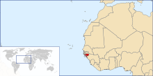
Ọdịdị ala nke Guinea-Bissau bụ nke ala dị larịị dị n'ụsọ oké osimiri Atlantic. Mba ahụ gbara Senegal n'ebe ugwu na Guinea n'ebe ndịda ọwụwa anyanwụ.
Ala na gburugburu ebe obibi
[dezie | dezie ebe o si]
Ala Guinea-Bissau bụ ala dị larịị dị ala n'ụsọ oké osimiri nke nwere ala mmiri nke mangroves nke Guinea na-arịgo na Guinea forest-savanna mosaic n'ebe ọwụwa anyanwụ.[1] Nnyocha nchọpụta zuru ụwa ọnụ na-adịbeghị anya na-atụ aro na e nwere 1,203km2 nke ala mmiri na Guinea-Bissau, na-eme ka ọ bụrụ mba nke iri abụọ na asatọ n'ihe gbasara ebe dị larịị.[2]
Ebe kachasị ala na Guinea-Bissau dị n'elu oké osimiri n'Oké Osimiri Atlantic.[1] Ebe kachasị elu na Guinea-Bissau bụ Monte Torin nke nwere ịdị elu nke 262 m (860 ).[1]
Ihe onwunwe sitere n'okike a chọtara na Guinea-Bissau gụnyere azụ, osisi, phosphates, bauxite, ụrọ, granite, limestone na mmanụ ala a na-ejighị eme ihe. 10.67% nke ala ahụ bụ nke a na-akọ ugbo na 235.6 square kilomita na-agba mmiri.[1][1]
Ihe ize ndụ sitere n'okike gụnyere ọkụ, kpọrọ nkụ, uzuzu harmattan nke nwere ike belata anya n'oge ọkọchị na ọkụ ọkụ.[1] Nsogbu gburugburu ebe obibi siri ike gụnyere mgbukpọ ọhịa; mbuze ala; ịtabiga nri ókè na igbubiga azụ ókè.[1]
N'akụkụ ókèala Senegal, e nweela akụkọ ihe mere eme nke nkịta ịchụ nta, Lycaon pictus, mana enwere ike iwepụ canid ahụ nọ n'ihe ize ndụ ugbu a n'ebe ahụ.
Ọnọdụ ihu igwe
[dezie | dezie ebe o si]Ọnọdụ ihu igwe Guinea-Bissau bụ nke okpomọkụ. Nke a pụtara na ọ na-ekpo ọkụ ma na-ekpuchi. Ọ nwere oge mmiri ozuzo (June ruo November) na ifufe ndịda ọdịda anyanwụ na oge ọkọchị (December ruo May) na ifufe ụgụrụ nke ugwu ọwụwa anyanwụ.[1]
Guinea-Bissau na-ekpo ọkụ n'afọ niile ma enwere obere mgbanwe okpomọkụ; ọ bụ nkezi 26.3 °C (79.3 ). Nkezi mmiri ozuzo maka isi obodo Bissau bụ 2,024 milimita (79.7 in) ọ bụ ezie na nke a fọrọ nke nta ka ọ bụrụ kpamkpam n'oge mmiri ozuzo nke -ada n'etiti June na September / October. Site n'ọnwa Disemba ruo n'ọnwa Eprel, mba ahụ na-enweta obere mmiri ozuzo.
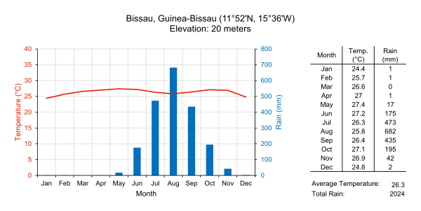
| Climate data for Bissau, Guinea-Bissau (1974-1994) | |||||||||||||
|---|---|---|---|---|---|---|---|---|---|---|---|---|---|
| Month | Jan | Feb | Mar | Apr | May | Jun | Jul | Aug | Sep | Oct | Nov | Dec | Year |
| Record high °C (°F) | 36.7 (98.1) |
38.3 (100.9) |
38.9 (102.0) |
41.1 (106.0) |
39.4 (102.9) |
35.6 (96.1) |
33.3 (91.9) |
32.8 (91.0) |
33.9 (93.0) |
34.4 (93.9) |
35.0 (95.0) |
35.6 (96.1) |
41.1 (106.0) |
| Average high °C (°F) | 31.1 (88.0) |
32.8 (91.0) |
33.9 (93.0) |
33.3 (91.9) |
32.8 (91.0) |
31.1 (88.0) |
29.4 (84.9) |
30.0 (86.0) |
30.0 (86.0) |
31.1 (88.0) |
31.7 (89.1) |
30.6 (87.1) |
31.5 (88.7) |
| Daily mean °C (°F) | 24.4 (75.9) |
25.6 (78.1) |
26.6 (79.9) |
27.0 (80.6) |
27.5 (81.5) |
26.9 (80.4) |
26.1 (79.0) |
26.4 (79.5) |
26.4 (79.5) |
27.0 (80.6) |
26.9 (80.4) |
24.8 (76.6) |
26.3 (79.3) |
| Average low °C (°F) | 17.8 (64.0) |
18.3 (64.9) |
19.4 (66.9) |
20.6 (69.1) |
22.2 (72.0) |
22.8 (73.0) |
22.8 (73.0) |
22.8 (73.0) |
22.8 (73.0) |
22.8 (73.0) |
22.2 (72.0) |
18.9 (66.0) |
21.1 (70.0) |
| Record low °C (°F) | 12.2 (54.0) |
13.3 (55.9) |
15.6 (60.1) |
16.7 (62.1) |
17.2 (63.0) |
19.4 (66.9) |
19.4 (66.9) |
19.4 (66.9) |
19.4 (66.9) |
20.0 (68.0) |
15.0 (59.0) |
12.8 (55.0) |
12.2 (54.0) |
| Average rainfall mm (inches) | 0.5 (0.02) |
0.8 (0.03) |
0.5 (0.02) |
0.8 (0.03) |
17.3 (0.68) |
174.8 (6.88) |
472.5 (18.60) |
682.5 (26.87) |
434.9 (17.12) |
194.8 (7.67) |
41.4 (1.63) |
2.0 (0.08) |
2,022.8 (79.63) |
| Mean monthly sunshine hours | 248 | 226 | 279 | 270 | 248 | 210 | 186 | 155 | 180 | 217 | 240 | 248 | 2,707 |
| Source 1: Sistema de Clasificación Bioclimática Mundial[3] | |||||||||||||
| Source 2: World Climate Guides (sunshine only)[4] | |||||||||||||
nno na mmiri Bissagos
[dezie | dezie ebe o si]
Ihe ọmụma sitere na CIA World Factbook
[dezie | dezie ebe o si]


- Location
- Western Africa, bordering the North Atlantic Ocean, between Guinea and Senegal
- Geographic coordinates
- Map references
- Area
-
- Total: 36,125 km2
- Land: 28,120 km2
- Water: 8,005 km2
- Area—comparative
- Slightly less than three times the size of Connecticut
- Land boundaries
- Coastline
- 350 km
- Maritime claims
- Territorial sea
- Lua error in package.lua at line 80: module 'Module:Convert/data' not found.
- Exclusive economic zone: Lua error in package.lua at line 80: module 'Module:Convert/data' not found.
- Terrain
- Mostly low coastal plain rising to savanna in east
- Elevation extremes
-
- Lowest point: Atlantic Ocean 0 m
- Highest point: Unnamed location in the northeast corner of the country 300 m
- Natural resources
- Fish, timber, phosphates, bauxite, unexploited deposits of petroleum
- Land use
-
- Arable land: 10.67%
- Permanent crops: 8.89%
- Other: 80.44% (2012 est.)
- Irrigated land
- 223.6 km2 (2003)
- Total renewable water resources
- 31 km3
- Freshwater withdrawal (domestic/industrial/agricultural)
-
- Total: 0.18 km3/yr (18%/6%/76%)
- Per capita: 135.7 m3/yr (2005)
- Natural hazards
- Hot, dry, dusty harmattan haze may reduce visibility during dry season; brush fires
- Environment—current issues
- Deforestation; soil erosion; overgrazing; overfishing
- Environment—international agreements
-
- Party to: Biodiversity, Climate Change, Desertification, Endangered Species, Hazardous Wastes, Law of the Sea, Ozone Layer Protection, Wetlands
- Signed, but not ratified: None of the selected agreements
Ebe ndị dị oke njọ
[dezie | dezie ebe o si]Nke a bụ ndepụta nke ebe ndị dị oke egwu nke Guinea-Bissau, ebe ndị dị n'ebe ugwu, ndịda, ọwụwa anyanwụ ma ọ bụ ọdịda anyanwụ karịa ebe ọ bụla ọzọ.
- Ebe kachasị n'ebe ugwu bụ akụkụ ugwu nke ókèala ya na Senegal*
- Ebe kachasị n'ebe ọwụwa anyanwụ bụ ebe a na-akpọghị aha n'ókè ya na Guinea ozugbo n'ebe ndịda ọdịda anyanwụ nke obodo Guinean nke Sofan, Gabú Region
- Ebe kachasị n'ebe ndịda bụ isi ala a na-akpọghị aha na Ilha Cataque, Tombali Region
- Ebe ọdịda anyanwụ - Cape Roxo n'ebe ókèala ya na Senegal na-abanye n'Oké Osimiri Atlantic, Cacheu Region
- *Rịba ama: Guinea-Bissau enweghị ebe kachasị n'ebe ugwu, ókèala ebe a bụ nke ahịrị kwụ ọtọ.
Hụkwa
[dezie | dezie ebe o si]Ihe edeturu n'ahịrị
[dezie | dezie ebe o si]- ↑ 1.0 1.1 1.2 1.3 1.4 1.5 1.6 1.7 U.S. Central Intelligence Agency. World Factbook
- ↑ Murray (2019). "The global distribution and trajectory of tidal flats". Nature 565: 222-225. DOI:10.1038/s41586-018-0805-8.
- ↑ GUINEA-BISSAU - BISSAU. Centro de Investigaciones Fitosociológicas.
- ↑ Bissau Climate Guide. Centro de Investigaciones Fitosociológicas.
Ebensidee
[dezie | dezie ebe o si]- [Ihe e dere n'ala ala peeji] Nkịta na-achụ nta e sere ese: Lycaon pictus, GlobalTwitcher.com, ed. N. Stromberg
- U.S. Central Intelligence Agency [1]